- The First Transcontinental Railroad was a 1,912-mile (3,077 km) contiguous railroad line constructed between 1863 and 1869 that connected the existing eastern U.S. rail network at Omaha, ... The Western Pacific Railroad Company built 132 mi (212 km) of track from Oakland/Alameda to Sacramento, California.
- A transcontinental railroad in the United States is any continuous rail line ... 1863 and 1869 to join the eastern and western halves of the United States. ... The Southern Pacific Railroad was completed in 1881.
- On this day in History, First transcontinental railroad is completed on May 10, ... For the first time in American history, railways linked together east and west, the ...
First Transcontinental Railroad
From Wikipedia, the free encyclopedia This article has multiple issues. Please help improve it or discuss these issues on the talk page. (Learn how and when to remove these template messages)
This article may contain an excessive amount of intricate detail that may only interest a specific audience. (August 2016) This article may be too long to read and navigate comfortably. (August 2016) 
At the ceremony for the driving of the "Last Spike" at Promontory Summit, Utah, May 10, 1869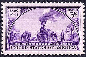
The First Transcontinental Railroad (known originally as the "Pacific Railroad" and later as the "Overland Route") was a 1,912-mile (3,077 km) contiguous railroad line constructed between 1863 and 1869 that connected the existing eastern U.S. rail network at Omaha, Nebraska/Council Bluffs, Iowa with the Pacific coast at the Oakland Long Wharf on San Francisco Bay.[1] The rail line was built by three private companies over public lands provided by extensive US land grants.[2] Construction was financed by both state and US government subsidy bonds as well as by company issued mortgage bonds.[3][4][5][N 1] The Western Pacific Railroad Company built 132 mi (212 km) of track from Oakland/Alameda to Sacramento, California. The Central Pacific Railroad Company of California (CPRR) constructed 690 mi (1,110 km) eastward from Sacramento to Promontory Summit, Utah Territory (U.T.). And the Union Pacific built 1,085 mi (1,746 km) from the road's eastern terminus at Council Bluffs near Omaha, Nebraska westward to Promontory Summit.[7][8][9]Transcontinental Railroad 75th Anniversary Issue stamp of 1944
The railroad opened for through traffic on May 10, 1869 when CPRR President Leland Stanford ceremonially drove the gold "Last Spike" (later often referred to as the "Golden Spike") with a silver hammer at Promontory Summit.[10][11] The coast-to-coast railroad connection revolutionized the settlement and economy of the American West. It brought the western states and territories into alignment with the northern Union states and made transporting passengers and goods coast-to-coast considerably quicker and less expensive.
Paddle steamers linked Sacramento to the cities and their harbor facilities in the San Francisco Bay until 1869, when the CPRR completed and opened the WP grade (which the CPRR had acquired control of in 1867–68 [N 2][N 3]) to Alameda and Oakland.
The first transcontinental rail passengers arrived at the Pacific Railroad's original western terminus at the Alameda Mole on September 6, 1869 where they transferred to the steamer Alameda for transport across the Bay to San Francisco. The road's rail terminus was moved two months later to the Oakland Long Wharf about a mile to the north.[15][16][N 4] Service between San Francisco and Oakland Pier continued to be provided by ferry.
The CPRR eventually purchased 53 miles of UPRR-built grade from Promontory Summit (MP 828) to Ogden, U.T. (MP 881), which became the interchange point between trains of the two roads. The transcontinental line was popularly known as the Overland Route after the principal passenger rail service that operated over the length of the line until 1962.[19]
Contents
Origins

Building a railroad line that connected the United States coast-to-coast was advocated in 1832 when Dr. Hartwell Carver published an article in the New York Courier & Enquirer advocating building a transcontinental railroad from Lake Michigan to Oregon. In 1847 he submitted to the U.S. Congress a "Proposal for a Charter to Build a Railroad from Lake Michigan to the Pacific Ocean", seeking a congressional charter to support his idea.[20][21]Title page of Dr. Hartwell Carver's 1847 Pacific Railroad proposal to Congress
Preliminary exploration

Congress agreed to support the idea. Under the direction of the Department of War, the Pacific Railroad Surveys were conducted from 1853 through 1855. These included an extensive series of expeditions of the American West seeking possible routes. A report on the explorations described alternative routes and included an immense amount of information about the American West, covering at least 400,000 sq mi (1,000,000 km2). It included the region's natural history and illustrations of reptiles, amphibians, birds, and mammals.[22]The official poster announcing the Pacific Railroad's grand opening.
The report failed however to include detailed topographic maps of potential routes needed to estimate the feasibility, cost and select the best route. The survey was detailed enough to determine that the best southern route lay south of the Gila River boundary with Mexico in mostly vacant desert, through the future territories of Arizona and New Mexico. This in part motivated the United States to complete the Gadsden Purchase.[23]
In 1856 the Select Committee on the Pacific Railroad and Telegraph of the US House of Representatives published a report recommending support for a proposed Pacific railroad bill:
The necessity that now exists for constructing lines of railroad and telegraphic communication between the Atlantic and Pacific coasts of this continent is no longer a question for argument; it is conceded by every one. In order to maintain our present position on the Pacific, we must have some more speedy and direct means of intercourse than is at present afforded by the route through the possessions of a foreign power.[24]
Possible routes
The U.S. Congress was strongly divided on where the eastern terminus of the railroad should be—in a southern or northern city.[25] Three routes were considered:
- A northern route roughly along the Missouri River through present-day northern Montana to Oregon Territory. This was considered impractical due to the rough terrain and extensive winter snows.[N 5]
- A central route following the Platte River in Nebraska through to the South Pass in Wyoming, following most of the Oregon Trail. Snow on this route remained a concern.
- A southern route across Texas, New Mexico Territory, the Sonora desert, connecting to Los Angeles, California. Surveyors found during a 1848 survey that the best route lay south of the border between the United States and Mexico. This was resolved by the Gadsen Purchase in 1853.[26][N 6]
- St. Joseph, Missouri, accessed via the Hannibal and St. Joseph Railroad.
- Kansas City, Kansas/Leavenworth, Kansas accessed via the Leavenworth, Pawnee and Western Railroad, controlled by Thomas Ewing Jr. and later by John C. Fremont.
- Council Bluffs/Omaha, accessed via an extension of Union Pacific financier Thomas C. Durant's proposed Mississippi and Missouri Railroad and the new Union Pacific Railroad, also controlled by Durant.
Key individuals

Leland Stanford and the officers of the CPRR in 1870Asa Whitney
One of the most prominent champions of the central route railroad was Asa Whitney. He envisioned a route from Chicago and the Great Lakes to northern California, paid for by the sale of land to settlers along the route. Whitney traveled widely to solicit support from businessmen and politicians, printed maps and pamphlets, and submitted several proposals to Congress, all at his own expense. In June 1845, he led a team along part of the proposed route to assess its feasibility.[27]
Legislation to begin construction of the Pacific Railroad (called the Memorial of Asa Whitney) was first introduced to Congress by Representative Zadock Pratt.[28] Congress did not immediately act on Whitney's proposal.
Theodore Judah
Main article: Theodore Judah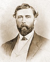
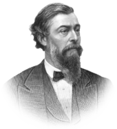
Theodore Judah, architect of the Transcontinental Railroad and first chief engineer of the Central Pacific.
The next big champion of the central route was Theodore Judah, who undertook to survey a manageable route through what was one of the chief obstacles of a central route to California, the high and rugged Sierra Nevada.Lewis M. Clement, Chief Assistant Engineer and Superintendent of Track
In 1852, Judah was chief engineer for the newly formed Sacramento Valley Railroad, the first railroad built west of the Mississippi River. Although the railroad later went bankrupt once the easy placer gold deposits around Placerville, California were depleted, Judah was convinced that a properly financed railroad could pass from Sacramento through the Sierra Nevada mountains to reach the Great Basin and hook up with rail lines coming from the East.[29]
In 1856, Judah wrote a 13,000-word proposal in support of a Pacific railroad and distributed it to Cabinet secretaries, congressmen and other influential people. In September 1859, Judah was chosen to be the accredited lobbyist for the Pacific Railroad Convention, which indeed approved his plan to survey, finance and engineer the road. Judah returned to Washington in December 1859. He had a lobbying office in the United States Capitol, received an audience with President James Buchanan, and represented the Convention before Congress.[30]
Judah returned to California in 1860. He continued to search for a more practical route through the Sierras suitable for a railroad. In mid-1860, local miner Daniel Strong had surveyed a route over the Sierras for a wagon toll road, which he realized would also suit a railroad. He described his discovery in a letter to Judah. Together, they formed an association to solicit subscriptions from local merchants and businessmen to support their proposed railroad.[30]
From January or February 1861 until July, Judah and Strong led a 10-person expedition to survey the route for the railroad over the Sierra Nevada through Clipper Gap and Emigrant Gap, over Donner Pass, and south to Truckee. They discovered a way across the Sierras that was gradual enough to be made suitable for a railroad, although it still needed a lot of work.[30]
The Big Four
- Main articles: The Big Four and Central Pacific Railroad

Four northern California businessmen formed the Central Pacific Railroad: Leland Stanford, (1824–1893), President; Collis Potter Huntington, (1821–1900), Vice President; Mark Hopkins, (1813–1878), Treasurer; Charles Crocker, (1822–1888), Construction Supervisor. All became substantially wealthy from their association with the railroad.Leland Stanford's official gubernatorial portrait
Thomas Durant
- Main articles: Thomas C. Durant and Union Pacific Railroad
Former ophthalmologist Dr. Thomas Clark "Doc" Durant was nominally only a vice president of Union Pacific, so he installed a series of respected men like John Adams Dix as president of the railroad. Durant and it's financing arrangements were, unlike the CPRR, mired in controversy and scandals.[citation needed]Dr. Thomas C. Durant
Authorization and funding
Main article: Pacific Railroad ActIn February 1860, Iowa Representative Samuel Curtis introduced a bill to fund the railroad. It passed the House but died when it could not be reconciled with the Senate version due to opposition from southern states who wanted a southern route near the 42nd parallel.[30] Curtis tried and failed again in 1861. After the southern states seceded from the Union, the House of Representatives approved the bill on May 6, 1862, and the Senate on June 20. Lincoln signed the Pacific Railroad Act of 1862 into law on July 1. It authorized creation of two companies, the Central Pacific in the west and the Union Pacific in the mid-west, to build the railroad. The legislation called for building and operating a new railroad from the Missouri River at Council Bluffs, Iowa, west to Sacramento, California, and on to San Francisco Bay.[31] A second law to supplement the first was passed in 1864.[32]
Federal financing
To finance the project, the act authorized the federal government to issue 30-year U.S. government bonds (at 6% interest). The railroad companies were paid $16,000/mile (approximately $422,000 today) for track laid on a level grade, $32,000/mile (about $844,000 today) for track laid in foothills, and $48,000/mile (or about $1,266,000 today) for track laid in mountains. The two railroad companies sold similar amounts of company-backed bonds and stock.[33]
The huge capital investment (over $100,000,000 in 1860 dollars, or about $2,638 billion today) needed was raised by selling the government-backed bonds and railroad company bonds and stock to interested private investors. The bonds would be repaid by selling the land granted to the railroads and the projected passenger and freight income.[citation needed]
Union Pacific financing
While the federal legislation for the Union Pacific required that no partner was to own more than 10 percent of the stock, the UP had problems selling its stock. One of the few subscribers was Mormon leader Brigham Young, who also supplied crews for building much of the railroad through Utah.[34] Durant enticed other investors by offering to front money for the stock they purchased in their names. This scheme enabled Durant to control about half of the railroad stock. The initial construction of UP grade traversed land owned by Durant. Durant's railroad was paid by the mile, and to further inflate its profits, the UP built oxbows of unneeded track, and by July 4, 1865, it had only reached 40 miles (64 km) from Omaha after 2½ years of construction.
Durant manipulated market prices on his stocks by spreading rumors about which railroads he had an interest in were being considered for connection with the Union Pacific. First he touted rumors that his fledgling M&M Railroad had a deal in the works, while secretly buying stock in the depressed Cedar Rapids and Missouri Railroad. Then he circulated rumors that the CR&M had plans to connect to the Union Pacific, at which point he began buying back the M&M stock at depressed prices. It's estimated his scams produced over $5 million in profits for he and his cohorts.[35]
Central Pacific financing
Collis Huntington, a Sacramento hardware merchant, heard Judah's presentation about the railroad at the St. Charles Hotel in November 1860. He invited Judah to his office to hear his proposal in detail. Huntington persuaded Judah to accept financing from himself and four others: Mark Hopkins, his business partner; James Bailey, a jeweler; Leland Stanford, a grocer; and Charles Crocker, a dry-goods merchant. They initially invested $1,500 each and formed a board of directors. These investors became known as The Big Four, and their railroad was called the Central Pacific Railroad. Each eventually made millions of dollars from their investments and control of the Central Pacific Railroad.
Before major construction could begin, Judah traveled back to New York City to raise funds to buy out The Big Four. However, shortly after arriving in New York, Judah died on November 2, 1863, of yellow fever that he had contracted while traveling over the Panama Railroad's transit of the Isthmus of Panama.[36] The CPRR Engineering Department was taken over by his successor Samuel S. Montegue, as well as Canadian trained Chief Assistant Engineer (later Acting Chief Engineer) Lewis Metzler Clement who also became Superintendent of Track.[37][30]
Land grants
To allow the companies to raise additional capital, Congress granted the railroads a 400-foot (120 m) right-of-way corridor, lands for additional facilities like sidings and maintenance yards. They were also granted alternate sections of government-owned lands—6,400 acres (2,600 ha) per mile (1.6 km)—for 10 miles (16 km) on both sides of the track, forming a checkerboard pattern, leaving federal land between those of the railroad. The exception was in cities, at rivers, or on non-government property.[citation needed] The railroads sold bonds based on the value of the lands, and in areas with good land like the Sacramento Valley and Nebraska[38] sold the land to settlers, contributing to a rapid settlement of the West.[39][verification needed] The total area of the land grants to the Union Pacific and Central Pacific was larger than the area of the state of Texas: federal government land grants totaled about 203,128,500 square miles, and state government land grants totaled about 76,565,000 square miles.[40]
It was far from a given that the railroads operating in the thinly-settled west would make enough money to repay their construction and operation. If the railroad companies failed to sell the land granted them within three years, they were required to sell it at prevailing government price for homesteads: $1.25 per 1 acre (0.40 ha). If they failed to repay the bonds, all remaining railroad property, including trains and tracks, would revert to the U.S. government.[citation needed] To encourage settlement in the west, Congress (1861–1863) passed the Homestead Acts which granted an applicant 160 acres (65 ha) of land with the requirement that the applicant improve the land. This incentive encouraged thousands of settlers to move west.[citation needed]
Railroad self-dealing
The federal legislation lacked adequate oversight and accountability. The two companies took advantage of these weaknesses in the legislation to manipulate the project and produce extra profit for themselves. Despite the generous subsidies offered by the federal government, the railroad capitalists knew they would not turn a profit on the railroad business for many months, possibly years. They determined to make a profit on the construction itself. Both groups of financiers formed independent companies to complete the project, and they controlled management of the new companies along with the railroad ventures. This self-dealing allowed them to build in generous profit margins paid out by the railroad companies. In the west, the four men heading the Central Pacific chose a simple name for their company, the "Contract and Finance Company." In the east, the Union Pacific selected an foreign name, calling their construction firm "Crédit Mobilier of America."[33] The latter company was later implicated in a far-reaching scandal, described later.
Labor and wages
Most of the engineers and surveyors who were hired by the Union Pacific had been employed during the U.S. Civil War to repair and operate the over 2,000 miles (3,200 km) of railroad line the U.S. Military Railroad controlled by the end of the war. The UP also utilized their experience repairing and building truss bridges during the war.[41] Most of the semi-skilled workers on the Union Pacific were recruited from the many soldiers discharged from the Union and Confederate armies along with emigrant Irishmen.[42]

After 1864, the Central Pacific Railroad received the same Federal financial incentives as the Union Pacific Railroad, along with some construction bonds granted by the state of California and the city of San Francisco. The Central Pacific hired some Canadian and British engineers and surveyors with extensive experience building railroads, but it had a difficult time finding semi-skilled labor. Most Caucasians in California preferred to work in the mines or agriculture. The railroad experimented by hiring local emigrant Chinese as manual laborers, many of whom were escaping the poverty and terrors of the Taiping Rebellion in the Guangdong province in China.[citation needed] When they proved themselves as workers, the CPRR from that point forward preferred to hire Chinese, and even set up recruiting efforts in Canton.[43] Despite their small stature[44] and lack of experience, the Chinese laborers were responsible for most of the heavy manual labor, since only a very limited amount of that work that could be done by animals, simple machines, or black powder. The railroad also hired some black people[45] escaping the aftermath of the American Civil War. Most of the black and white workers were paid $30.00/month and given food and lodging. Most Chinese were initially paid $31.00/month and provided lodging, but they preferred to cook their own meals. In 1867 the CPRR raised their wage to $35.00/month after a strike.[43][46][47]Pacific Railroad Bond, City and County of San Francisco, 1865
Transcontinental route
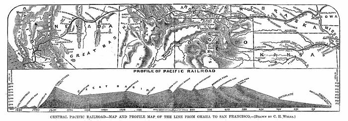
Profile of the Pacific Railroad from Council Bluffs/Omaha to San Francisco. Harper's Weekly December 7, 1867Construction begun
The Central Pacific broke ground on January 8, 1863. Due to the lack of transportation alternatives from the manufacturing centers on the east coast, virtually all of their tools and machinery including rails, railroad switches, railroad turntables, freight and passenger cars, and steam locomotives were transported first by train to east coast ports. They were then loaded on ships which either sailed around South America's Cape Horn, or offloaded the cargo at the Isthmus of Panama, where it was sent across via paddle steamer and the Panama Railroad. The Panama Railroad gauge was 5 feet (1.5 m), which was incompatible with the 4 ft 8 1⁄2 inch gauge used by the CPRR equipment. The latter route was about twice as expensive per pound.[citation needed] Once the machinery and tools reached the San Francisco Bay area, they were put aboard river paddle steamers which transported them up the final 130 miles (210 km) of the Sacramento River to the new state capital in Sacramento. Many of these steam engines, railroad cars, and other machinery were shipped dismantled and had to be reassembled.[citation needed] Wooden timbers for railroad ties, trestles, bridges, firewood, and telegraph poles were harvested in California and transported to the project site.
The Union Pacific Railroad did not start construction for another 18 months until July 1865. They were delayed by difficulties obtaining financial backing and the unavailability of workers and materials due to the Civil War. Their start point in the new city of Omaha, Nebraska was not yet connected via railroad to Council Bluffs, Iowa. Equipment needed to begin work was initially delivered to Omaha and Council Bluffs by paddle steamers on the Missouri River. The Union Pacific was so slow in beginning construction during 1865 that they sold two of the four steam locomotives they had purchased.[citation needed]
After the U.S. Civil War ended on June 22, 1865, the Union Pacific still competed for railroad supplies with companies who were building or repairing railroads in the south, and prices rose.[citation needed]
Rail standards
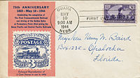
At that time in the United States, there were two primary standards for track gauge, the distance between the rails. In England, the standard gauge was 4 ft 8 1⁄2 inch (1.435 m), and this had been adopted by the majority of northern railways. But the south had adopted a 5-foot gauge. Transferring railway cars and locomotives between different railways required changing out the wheel trucks. Alternatively, cargo was offloaded and reloaded, a time-consuming effort the delayed cargo shipments. For the transcontinental railroad, the builders adopted the English standard, what is now called standard gauge.[48]First Day Cover for the 75th Anniversary of the Driving of the Last Spike (May 10, 1944)
The Bessemer process and open hearth furnace steel-making were in use by 1865, but the advantages of steel rails which lasted much longer than iron rails had not yet been demonstrated.[citation needed] The rails used initially in building the rail way were nearly all made of iron of a flat-bottomed modified I-beam profile weighing 56 pounds (25 kg) per 1 yard (0.91 m) or 66 pounds (30 kg) per 1 yard (0.91 m).[citation needed] The railroad companies were intent on completing the project as rapidly as possible at a minimum cost. Within a few years, nearly all railroads converted to steel rails.
Time zones and telegraph usage
Time was not standardized across the United States until about 1883. In 1865, each railroad set its own time to minimize scheduling errors. To communicate easily up and down the line, the railroads built telegraph lines alongside the railroad. These lines eventually superseded the original First Transcontinental Telegraph which followed much of the Mormon Trail up the North Platte River and across the very thinly populated Central Nevada Route through central Utah and Nevada. The telegraph lines along the railroad were easier to protect and maintain. Many of the original telegraph lines were abandoned as the telegraph business was consolidated with the railroad telegraph lines.
Union Pacific route

This section needs additional citations for verification. (May 2016) (Learn how and when to remove this template message) 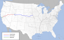
The Union Pacific's 1,087 miles (1,749 km) of track started at MP 0.0 in Council Bluffs, Iowa,[7] on the eastern side of the Missouri River. Omaha was chosen by President Abraham Lincoln as the location of its Transfer Depot where up to seven railroads could transfer mail and other goods to Union Pacific trains bound for the west.Route of the first American transcontinental railroad from Sacramento, California, to Council Bluffs, Iowa. Other railroads connected at Council Bluffs to cities throughout the East and Midwest.
Trains were initially transported across the Missouri River by ferry before they could access the western tracks beginning in Omaha, Nebraska Territory. The river froze in the winter, and the ferries were replaced by sleighs. A bridge was not built until 1873, when the new 2,750 feet (840 m) long Union Pacific Missouri River Bridge was completed.
After the rail line's initial climb through the Missouri River bluffs west of Omaha and out of the Missouri River Valley, the route bridged the Elkhorn River and then crossed over the new 1,500 feet (460 m) Loup River bridge as it followed the north side of the Platte River valley west through Nebraska along the general path of the Oregon, Mormon and California Trails.
By December 1865, the Union Pacific had only completed 40 miles (64 km) of track, reaching Fremont, Nebraska, and a further 10 miles (16 km) of roadbed.[49]
At the end of 1865, Peter A. Dey, Chief Engineer of the Union Pacific, resigned over a routing dispute with Thomas C. Durant, one of the chief financiers of the Union Pacific.[citation needed]
With the end of the Civil War and increased government supervision in the offing, Durant hired his former M&M engineer Grenville M. Dodge to build the railroad, and the Union Pacific began a mad dash west.[citation needed]
Former Union General John "Jack" Casement was hired as the new Chief Engineer of the Union Pacific. He equipped several railroad cars to serve as portable bunkhouses for the workers and gathered men and supplies to push the railroad rapidly west. Among the bunkhouses Casement added a galley car to prepare meals, and he even provided for a herd of cows to be moved with the rail head and bunk cars to provide fresh meat. Hunters were hired to provide buffalo meat from the large herds of American bison.[citation needed]
The small survey parties who scouted ahead to locate the roadbed were sometimes attacked and killed by raiding Indian. In response, the U.S. Army instituted active cavalry patrols that grew larger as the Indians grew more aggressive. Temporary, "hell-on-wheels" towns, made mostly of canvas tents, accompanied the railroad as construction headed west.[citation needed]
The Platte River was too shallow and meandering to provide river transport, but the Platte river valley headed west and sloped up gradually at about 6 feet (1.8 m) per 1 mile (1.6 km), often allowing to lay a mile (1.6 km) of track a day or more in 1866 as the Union Pacific finally started moving rapidly west. Building bridges to cross creeks and rivers was the main source of delays. Near where the Platte River splits into the North Platte River and South Platte River, the railroad bridged the North Platte River over a 2,600 feet (790 m) long bridge (nicknamed ½ mile bridge). It was built across the shallow but wide North Platte resting on piles driven by steam pile drivers.[50] Here they built the "railroad" town of North Platte, Nebraska in December 1866 after completing about 240 miles (390 km) of track that year. In late 1866, former Major General Grenville M. Dodge was appointed Chief Engineer on the Union Pacific, but hard working General "Jack" Casement continued to work as chief construction "boss" and his brother Daniel Casement continued as financial officer.
The original emigrant route across Wyoming of the Oregon, Mormon and California Trails, after progressing up the Platte River valley, went up the North Platte River valley through Casper, Wyoming, along the Sweetwater River and over the Continental Divide at 7,412 feet (2,259 m) South Pass. The original westward travellers in their ox and mule pulled wagons tried to stick to river valleys to avoid as much road building as possible—gradients and sharp corners were usually of little or no concern to them. The ox and mule pulled wagons were the original off-road vehicles in their day, since nearly all of the Emigrant Trails went cross country over rough, un-improved trails. The route over South Pass's main advantage for wagons pulled by oxen or mules was a shorter elevation over an "easy" pass to cross and its "easy" connection to nearby river valleys on both sides of the continental divide for water and grass. The emigrant trails were closed in winter. The North Platte/South Pass route was far less beneficial for a railroad, as it was about 150 miles (240 km) longer and much more expensive to construct up the narrow, steep and rocky canyons of the North Platte. The route along the North Platte was also further from Denver, Colorado, and went across difficult terrain, while a railroad connection to that City was already being planned for and surveyed.
Efforts to survey a new, shorter, "better" route had been under way since 1864. By 1867, a new route was found and surveyed that went along part of the South Platte River in western Nebraska and after entering what is now the state of Wyoming, ascended a gradual sloping ridge between Lodgepole Creek and Crow Creek to 8,200 feet (2,500 m) Evans pass (also called Sherman's Pass) which was discovered by the Union Pacific employed English surveyor and engineer, James Evans, in about 1864.[51] This pass now is marked by the Ames Monument (41.131281,-105.398045 lat., long.) marking its significance and commemorating two of the main backers of the Union Pacific Railroad. From North Platte, Nebraska (elevation 2,834 feet (864 m)), the railroad proceeded westward and upward along a new path across the Nebraska Territory and Wyoming Territory (then part of the Dakota Territory) along the north bank of the South Platte River and into what would become the state of Wyoming at Lone Pine, Wyoming. Evans Pass was located between what would become the new "railroad" towns of Cheyenne and Laramie. Connecting to this pass, about 15 miles (24 km) west of Cheyenne, was the one place across the Laramie Mountains that had a narrow "guitar neck" of land that crossed the mountains without serious erosion at the so-called "gangplank" (41.099746,-105.153205 lat., long.) discovered by Major General Grenville Dodge in 1865 when he was in the U.S. Army.[52] The new route surveyed across Wyoming was over 150 miles (240 km) shorter, had a flatter profile, allowed for cheaper and easier railroad construction, and also went closer by Denver and the known coalfields in the Wasatch and Laramie Ranges.
The railroad gained about 3,200 feet (980 m) in the 220 miles (350 km) climb to Cheyenne from North Platte, Nebraska—about 15 feet (4.6 m) per mile (1.6 km)--a very gentle slope of less than one degree average. This "new" route had never become an emigrant route because it lacked the water and grass to feed the emigrants' oxen and mules. Steam locomotives did not need grass, and the railroad companies could drill wells for water if necessary.
Coal had been discovered in Wyoming and reported on by John C. Frémont in his 1843 expedition across Wyoming, and was already being exploited by Utah residents from towns like Coalville, Utah and later Kemmerer, Wyoming by the time the Transcontinental railroad was built. Union Pacific needed coal to fuel its steam locomotives on the almost treeless plains across Nebraska and Wyoming. Coal shipments by rail were also looked on as a potentially major source of income—this potential is still being realized.

The Union Pacific reached the new railroad town of Cheyenne in December 1867, having laid about 270 miles (430 km) that year. They paused over the winter, preparing to push the track over Evans (Sherman's) pass. At 8,247 feet (2,514 m), Evans/Sherman's pass is the highest point reached on the transcontinental railroad. About 4 miles (6.4 km) beyond Evans/Sherman's pass, the railroad had to build an extensive bridge over the Dale Creek canyon (41.103803, −105.454797, lat., long.). The Dale Creek Crossing was one of their more difficult railroad engineering challenges.[53] Dale Creek Bridge was 650-foot (200 m) long and 125 feet (38 m) above Dale Creek.[54] The bridge components were pre-built of timber in Chicago, Illinois and then shipped on rail cars to Dale Creek for assembly. The eastern and western approaches to the bridge site, near the highest elevation on the transcontinental railroad, required cutting through granite for nearly a mile on each side.[55] The initial Dale Creek bridge had a train speed limit of 4 miles (6.4 km) per hour across the bridge. Beyond Dale Creek, railroad construction paused at what became the town of Laramie, Wyoming to build a bridge across the Laramie River.Dale Creek Bridge
Located 35 miles (56 km) from Evans pass, Union Pacific connected the new "railroad" town of Cheyenne to Denver and its Denver Pacific Railway and Telegraph Company railroad line in 1870. Elevated 6,070 feet (1,850 m) above sea level, and sitting on the new Union Pacific route with a connection to Denver, Cheyenne was chosen to become a major railroad center and was equipped with extensive railroad yards, maintenance facilities and a Union Pacific presence. Its location made it a good base for helper locomotives to couple to trains with snowplows to help clear the tracks of snow or help haul heavy freight over Evans pass. The Union Pacific's junction with the Denver Railroad with its connection to Kansas City, Kansas, Kansas City, Missouri and the railroads east of the Missouri River again increased Cheyenne's importance as the junction of two major railroads. Cheyenne later became Wyoming's largest city and the capital of the new state of Wyoming.
The railroad established many townships along the way: Fremont, Elkhorn, Grand Island, North Platte, Ogallala and Sidney as the railroad followed the Platte River across Nebraska territory. The railroad even dipped into what would become the new state of Colorado after crossing the North Platte River as it followed the South Platte River west into what would become Julesburg before turning northwest along Lodgepole Creek into Wyoming. In the Dakota Territory (Wyoming) the new towns of Cheyenne, Laramie, Rawlins (named for Union General John Aaron Rawlins, who camped in the locality in 1867.[56]), Green River and Evanston (named after James Evans) were established, as well as many more fuel and water stops. The Green River was crossed with a new bridge, and the new "railroad" town of Green River constructed there after the tracks reached the Green River on October 1, 1868—the last big river to cross.
On December 4, 1868, the Union Pacific reached Evanston, having laid almost 360 miles (580 km) of track over the Green River and the Laramie Plains that year. By 1871, Evanston became a significant maintenance shop town equipped to carry out extensive repairs on the cars and steam locomotives.
In the Utah Territory, the railroad once again diverted from the main emigrant trails to cross the Wasatch Mountains and went down the rugged Echo Canyon (Summit County, Utah) and Weber River canyon. To speed up construction as much as possible, Union Pacific contracted several thousand Mormon workers to cut, fill, trestle, bridge, blast and tunnel its way down the rugged Weber River Canyon to Ogden, Utah, ahead of the railroad construction. The Mormon and Union Pacific rail work was joined in the area of the present-day border between Utah and Wyoming.[57] The longest of four tunnels built in Weber Canyon was 757 feet (231 m) long Tunnel 2. Work on this tunnel started in October 1868 and was completed six months later. Temporary tracks were laid around it and Tunnels 3 (508 feet (155 m)), 4 (297 feet (91 m)) and 5 (579 feet (176 m)) to continue work on the tracks west of the tunnels.
The tunnels were all made with the new dangerous nitroglycerine explosive which expedited work but caused some fatal accidents.[58] While building the railroad along the rugged Weber River Canyon, Mormon workers signed the Thousand Mile Tree which was lone tree alongside the track 1,000 miles (1,600 km) from Omaha. A historic marker has been placed there.[59]
The tracks reached Ogden, Utah, on March 27, 1869, although finishing work would continue on the tracks, tunnels and bridges in Weber Canyon for over a year. From Ogden, the railroad went north of the Great Salt Lake to Brigham City and Corinne using Mormon workers, before finally connecting with the Central Pacific Railroad at Promontory Summit in Utah territory on May 10, 1869.[60][61] Some Union Pacific officers declined to pay the Mormons all of the agreed upon construction costs of the work through Weber Canyon, and beyond, claiming Union Pacific poverty despite the millions they had extracted through the Crédit Mobilier of America scandal. Only partial payment was secured through court actions against Union Pacific. Fortunately, the Union Pacific railroad land grants in Utah were mostly worthless territory through mountains and deserts so they did not gain too much extra.[57] The portion of the original railroad around the north shore of the Great Salt Lake is no longer used. In 1904, the Lucin Cutoff, a causeway across the center of the Great Salt Lake to Promontory Point, bypassed Promontory Summit. The cutoff shortened the rail route by approximately 43 miles (69 km).
Central Pacific route
This section needs additional citations for verification. (May 2016) (Learn how and when to remove this template message) 
The Central Pacific laid 690 miles (1,110 km) of track, starting in Sacramento, California, in 1863 and continuing over the rugged 7,000-foot (2,100 m) Sierra Nevada mountains at Donner Pass into the new state of Nevada. The elevation change from Sacramento (elev. 40 ft or 12 m) to Donner summit (elev. 7,000 ft or 2,100 m) had to be accomplished in about 90 miles (140 km) with an average elevation change of 76 feet per mile (14 meters per km), and there were only a few places in the Sierras where this type of "ramp" existed. The discovery and detailed map survey with profiles and elevations of this route over the Sierra Nevada (U.S.) is credited to Theodore Judah, chief engineer of the Central Pacific Railroad up till his death in 1863. This route is up a ridge between the North fork of the American River on the south and Bear River (Feather River) and South Yuba River on the north. As the railroad climbed out of Sacramento up to Donner summit, there was only one 3-mile (4.8 km) section near "Cape Horn CPRR"[62] where the railroad grade slightly exceeded two percent.Central Pacific Rail road at Cape Horn circa 1880
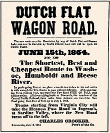
In June 1864, the Central Pacific railroad entrepreneurs opened Dutch Flat and Donner Lake Wagon Road (DFDLWR).[63] Costing about $300,000 and a years worth of work, this toll road wagon route was opened over much of the route the Central Pacific railroad (CPRR) would use over Donner Summit to carry freight and passengers needed by the CPRR and to carry other cargo over their toll road to and from the ever advancing rail head and over the Sierras to the gold and silver mining towns of Nevada. As the railroad advanced, their freight rates with the combined rail and wagon shipments would become much more competitive. The volume of the toll road freight traffic to Nevada was estimated to be about $13,000,000 a year as the Comstock Lode boomed, and getting even part of this freight traffic would help pay for the railroad construction. When the railroad reached Reno, it had the majority of all Nevada freight shipments, and the price of goods in Nevada dropped significantly as the freight charges to Nevada dropped significantly. The rail route over the Sierras followed the general route of the Truckee branch of the California Trail, going east over Donner Pass and down the rugged Truckee River valley.1864 advertisement for the opening of the Dutch Flat Wagon Road.
The route over the Sierra had been plotted out by Judah in preliminary surveys before his death in 1863. Judah's deputy, Samuel S. Montague was appointed as Central Pacific's new Chief Engineer, with Lewis M. Clement as Assistant Chief Engineer and Charles Cadwalader as second assistant. To build the new railroad, detailed surveys had to be run that showed where the cuts, fills, trestles, bridges and tunnels would have to be built. Work that was identified as taking a long time was started as soon as its projected track location could be ascertained and work crews, supplies and road work equipment found to be sent ahead. Tunnels, trestles and bridges were nearly all built this way. The spread-out nature of the work resulted in the work being split into two divisions, with L.M. Clement taking the upper division from Blue Cañon to Truckee and Cadwalader taking the lower division from Truckee to the Nevada border. Other assistant engineers were assigned to specific tasks such as building a bridge, tunnel or trestle which was done by the workers under experienced supervisors.[37]

In total, the Central Pacific had eleven tunnel projects (Nos. 3 through 13) under construction in the Sierra from 1865–68, with seven tunnels located in a 2-mile (3.2 km) stretch on the east side of Donner Summit. The tunnels were usually built by drilling a series of holes in the tunnel face, filling them with black powder and detonating it to break the rock free. The black powder was provided by the California Powder Works near Santa Cruz, California. These works had started production in 1864 after the U.S. Civil War had cut off shipments of black powder from the East to the mining and railroad industry of California and Nevada. The Central Pacific was a prolific user of black powder, often using up to 500 kegs of 25 pounds (11 kg) each per day.[64]The CPRR grade at Donner Summit as it appeared in 1869 and 2003.
The summit tunnel (Number 6), 1,660 feet (510 m), was started in late 1865, well ahead of the rail head. Through solid granite, the summit tunnel progressed at a rate of only about 0.98 feet (0.30 m) per day per face as it was being worked by three eight-hour shifts of workers, hand drilling holes with a rock drill and hammer, filling them with black powder and trying to blast the granite loose. One crew worked drilling holes on the faces and another crew collected and removed the loosened rock after each explosion. The workers were pulled off the summit tunnel and the track grading east of Donner pass in the winter of 1865/66 as there was no way to supply them, nor quarters they could have lived in. The crews were transferred to work on bridges and track grading on the Truckee River canyon.

In 1866 they put in a 125-foot (38 m) vertical shaft in the center of the summit tunnel and started work towards the east and west tunnel faces, giving four working faces on the summit tunnel to speed up progress. A steam engine off an old locomotive was brought up with much effort over the wagon road and used as a winch driver to help remove loosened rock from the vertical shaft and two working faces. By the winter of 1866/67, work had progressed sufficiently and a camp had been built for workers on the summit tunnel which allowed work to continue. The cross section of a tunnel face was a 16-foot-wide (4.9 m), 16-foot-high (4.9 m) oval with an 11-foot (3.4 m) vertical wall. Progress on the tunnel sped up to over 1.5 feet (0.46 m) per day per face when they started using the newly discovered nitroglycerin—manufactured near the tunnel. They used nitroglycerin to deepen the summit tunnel to the required 16-foot (4.9 m) height after the four tunnel faces met, and made even faster progress. Nearly all other tunnels were worked on both tunnel faces and met in the middle. Depending on the material the tunnels penetrated, they were left unlined or lined with brick, rock walls or timber and post. Some tunnels were designed to bend in the middle to align with the track bed curvature. Despite this potential complication, nearly all the different tunnel center lines met within 2 inches (5.1 cm) or so. The detailed survey work that made these tunnel digs as precise as required were nearly all done by the Canadian born and trained Lewis Clement, the CPRR's Chief Assistant Engineer and Superintendent of Track, and his assistants.[37]The vertical central shaft of the CPRR "Summit Tunnel" (Tunnel #6) at Donner Summit which allowed drilling and excavation to be carried out on four faces at once.
Hills or ridges in front of the railroad road bed would have to have a flat-bottomed, V shaped "cut" made to get the railroad through the ridge or hill. The type of material determined the slope of the V and how much material would have to be removed. Ideally, these cuts would be matched with valley fills that could use the dug out material to bring the road bed up to grade--cut and fill construction. In the 1860s there was no heavy equipment that could be used to make these cuts or haul it away to make the fills. The options were to dig it out by pick and shovel, haul the hillside material by wheelbarrow and/or horse or mule cart or blast it loose. To blast a V shaped cut out, they had to drill several holes up to 20 feet (6.1 m) deep in the material, fill them with black powder, and blast the material away. Since the Central Pacific was in a hurry, they were profligate users of black powder to blast their way though the hills. The only disadvantage came when a nearby valley needed fill to get across it. The explosive technique often blew most of the potential fill material down the hillside, making it unavailable for fill.[65][66] Initially, many valleys were bridged by "temporary" trestles that could be rapidly built and were later replaced by much lower maintenance and permanent solid fill. The existing railroad made transporting and putting material in valleys much easier—load it on railway dump cars, haul where needed and dump it over the side of the trestle.
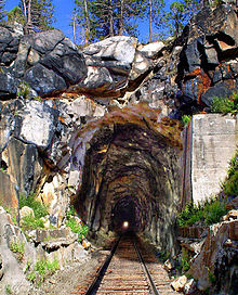
The route down the eastern Sierras was done on the south side of Donner Lake with a series of switchbacks carved into the mountain. The Truckee River, which drains Lake Tahoe, had already found and scoured out the best route across the Carson Range of mountains east of the Sierras. The route down the rugged Truckee River Canyon, including required bridges, was done ahead of the main summit tunnel completion. To expedite the building of the railroad through the Truckee River canyon, the Central Pacific hauled two small locomotives, railcars, rails and other material on wagons and sleighs to what is now Truckee, California and worked the winter of 1867/68 on their way down Truckee canyon ahead of the tracks being completed to Truckee. In Truckee canyon, five Howe truss bridges had to be built. This gave them a head start on getting to the "easy" miles across Nevada.The Summit Tunnel at Donner Summit, West Portal
In order to keep the higher portions of the Sierra grade open in the winter, 37 miles (60 km) of timber snow sheds were built between Blue Cañon and Truckee in addition to utilizing snowplows pushed by locomotives, as well as manual shovelling. With the advent of more efficient oil fired steam and later diesel electric power to drive plows, flangers, spreaders, and rotary snow plows, most of the wooden snowsheds have long since been removed as obsolete. Tunnels 1–5 and 13 of the original 1860s tunnels on Track 1 of the Sierra grade remain in use today, while additional new tunnels were later driven when the grade was double tracked over the first quarter of the twentieth century. In 1993, the Southern Pacific Railroad (which operated the CPRR-built Oakland–Ogden line until its 1996 merger with the UP) closed and pulled up the 6.7-mile (10.8 km) section of Track #1 over the summit running between the Norden complex (Shed 26, MP 192.1)[67] and the covered crossovers in Shed #47 (MP 198.8)[68] about a mile east of the old flyover at Eder, bypassing and abandoning the tunnel 6–8 complex, the concrete snowsheds just beyond them, and tunnels 9–12 ending at MP 195.7, all of which had been located on Track 1 within two miles of the summit.[69] Since then all east- and westbound traffic has been run over the Track #2 grade crossing the summit about one mile (1.6 km) south of Donner Pass through the 10,322-foot-long (3,146 m) Tunnel #41 (aka "The Big Hole") running under Mt. Judah between Soda Springs and Eder, which was opened in 1925 when the summit section of the grade was double tracked. This routing change was made because the Track 2 and Tunnel 41 Summit crossing is far easier and less expensive to maintain and keep open in the harsh Sierra winters.[70]
On June 18, 1868, the Central Pacific reached Reno, Nevada, after completing 132 miles (212 km) of railroad up and over the Sierras from Sacramento, California. By then the railroad had already been prebuilt down the Truckee River on the much flatter land from Reno to Wadsworth, Nevada, where they bridged the Truckee for the last time. From there, they struggled across a forty mile desert to the end of the Humboldt river at the Humboldt Sink. From the end of the Humboldt, they continued east over the Great Basin desert bordering the Humboldt River to Wells, Nevada. One of the most troublesome problems found on this route along the Humboldt was at Palisade Canyon (near Carlin, Nevada), where for 12 miles (19 km) the line had to be built between the river and basalt cliffs. From Wells, Nevada to Promontory Summit, the Railroad left the Humboldt and proceeded across the Nevada and Utah desert. Water for the steam locomotives was provided by wells, springs, or pipelines to nearby water sources. Water was often pumped into the water tanks with windmills. Train fuel and water spots on the early trains with steam locomotives may have been as often as every 10 miles (16 km). On one memorable occasion, not far from Promontory, the Central Pacific crews organized an army of workers and five train loads of construction material, and laid 10 miles (16 km) of track on a prepared rail bed in one day—-a record that still stands today. The Central Pacific and Union Pacific raced to get as much track laid as possible, and the Central Pacific laid about 560 miles (900 km) of track from Reno to Promontory Summit in the one year before the Last Spike was driven on May 10, 1869.
Central Pacific had 1,694 freight cars available by May 1869, with more under construction in their Sacramento yard. Major repairs and maintenance on the Central Pacific rolling stock was done in their Sacramento maintenance yard. Near the end of 1869, Central Pacific had 162 locomotives, of which 2 had two drivers (drive wheels), 110 had four drivers, and 50 had six drivers. The steam locomotives had been purchased in the eastern states and shipped to California by sea. Thirty-six additional locomotives were built and coming west, and twenty-eight more were under construction. There was a shortage of passenger cars and more had to be ordered. The first Central Pacific sleeper, the "Silver Palace Sleeping Car", arrived at Sacramento on June 8, 1868.[71]
The CPRR route passed through Newcastle and Truckee in California, Reno, Wadsworth, Winnemucca, Battle Mountain, Elko and Wells in Nevada (with many more fuel and water stops), before connecting with the Union Pacific line at Promontory Summit in the Utah Territory. When the eastern end of the CPRR was extended to Ogden by purchasing the Union Pacific Railroad line from Promontory for about $2.8 million in 1870, it ended the short period of a boom town for Promontory, extended the Central Pacific tracks about 60 miles (97 km) and made Ogden a major terminus on the transcontinental railroad, as passengers and freight switched railroads there.

With the opening four months after the railheads met at Promontory Summit, U.T. of the original San Joaquin River Bridge at Mossdale Crossing on September 8, 1869 near present-day Lathrop, the western part of the route was extended from Sacramento the Alameda Terminal in Alameda, California, and shortly thereafter, to the Oakland Long Wharf at Oakland Point in Oakland, California, and on to San Jose, California. Train ferries transferred some railroad cars to and from the Oakland wharves and tracks to wharves and tracks in San Francisco. Before the CPRR was completed, developers were building other feeder railroads like the Virginia and Truckee Railroad to the Comstock Lode diggings in Virginia City, Nevada, and several different extensions in California and Nevada to reach other cities there. Some of their main cargo was the thousands of cords of firewood needed for the many steam engines and pumps, cooking stoves, heating stoves etc. in Comstock Lode towns and the tons of ice needed by the miners as they worked ever deeper into the "hot" Comstock Lode ore body. In the mines, temperatures could get above 120 °F (49 °C) at the work face and a miner often used over 100 pounds (45 kg) of ice per shift. This new railroad connected to the Central Pacific near Reno, and went through Carson City, the new capital of Nevada.[72]CPRR issued ticket for passage from Reno to Virginia City, NV on the V&TRR, 1878
After the transcontinental railroads were completed, many other railroads were built to connect up to other population centers in Utah, Wyoming, Kansas, Colorado, Oregon, Washington territories, etc. In 1869, the Kansas Pacific Railway started building the Hannibal Bridge, a swing bridge across the Missouri River between Kansas City, Missouri and Kansas City, Kansas which connected railroads on both sides of the Missouri while still allowing passage of paddle steamers on the river. After completion, this became another major east-west railroad. To speed completion of the Kansas Pacific Railroad to Denver, construction started east from Denver in March 1870 to meet the railroad coming west from Kansas city. The two crews met at a point called Comanche Crossing, Kansas Territory, on August 15, 1870. Denver was now firmly on track to becoming the largest city and the future capitol of Colorado. The Kansas Pacific Railroad linked with the Denver Pacific Railway via Denver to Cheyenne in 1870.
The original transcontinental railroad route did not pass through the two biggest cities in the so-called Great American Desert—Denver, Colorado, and Salt Lake City, Utah. Feeder railroad lines were soon built to service these two and other cities and states along the route.
Modern-day Interstate 80 closely follows the path of the railroad from Sacramento across modern day California, Nevada, Wyoming and Nebraska, with two major exceptions: Interstate-80 crosses Donner Summit and proceeds east down the north side of Donner Lake while the railroad goes down the south side; and east of Wells, Nevada, Interstate 80 passes through Wendover, Utah and then goes across the salt flats on the south shore of the Great Salt Lake on its way to Salt Lake City, while the original railroad went on the north side and now goes across the Great Salt Lake. The Interstate then passes up Parley's Canyon before rejoining the railroad near the Echo Canyon junction of Interstate 84 and Interstate 80.
I-84, built much later, blasted its way down Weber Canyon with no tunnels. The interstate diverges from the railroad route in rugged terrain as it was built much later, with much more powerful equipment, better explosives and at much higher cost. In addition, interstate highways can tolerate up to about six-percent grades which allows them to go many places the railroads had to go around, since their goal was to hold their grades to less than two percent.
Construction

Most of the capital investment needed to build the railroad was generated by selling government-guaranteed bonds (granted per mile of completed track) to interested investors. The Federal donation of right-of-way saved money and time as it did not have to be purchased from others. The financial incentives and bonds would hopefully cover most of the initial capital investment needed to build the railroad. The bonds would be paid back by the sale of government-granted land, as well as prospective passenger and freight income. Most of the engineers and surveyors who figured out how and where to build the railroad on the Union Pacific were engineering college trained. Many of Union Pacific engineers and surveyors were Union Army veterans (including two generals) who had learned their railroad trade keeping the trains running and tracks maintained during the U.S. Civil War. After securing the finances and selecting the engineering team, the next step was to hire the key personnel and prospective supervisors. Nearly all key workers and supervisors were hired because they had previous railroad on-the-job training, knew what needed to be done and how to direct workers to get it done. After the key personnel were hired, the semi-skilled jobs could be filled if there was available labor. The engineering team's main job was to tell the workers where to go, what to do, how to do it, and provide the construction material they would need to get it done.The Jupiter, which carried Leland Stanford (one of the "Big Four" owners of the Central Pacific) and other railway officials to the Last Spike Ceremony.
Survey teams were put out to produce detailed contour maps of the options on the different routes. The engineering team looked at the available surveys and chose what was the "best" route. Survey teams under the direction of the engineers closely led the work crews and marked where and by how much hills would have to be cut and depressions filled or bridged. Coordinators made sure that construction and other supplies were provided when and where needed, and additional supplies were ordered as the railroad construction consumed the supplies. Specialized bridging, explosive and tunneling teams were assigned to their specialized jobs. Some jobs like explosive work, tunneling, bridging, heavy cuts or fills were known to take longer than others, so the specialized teams were sent out ahead by wagon trains with the supplies and men to get these jobs done by the time the regular track-laying crews arrived. Finance officers made sure the supplies were paid for and men paid for their work. An army of men had to be coordinated and a seemingly never-ending chain of supplies had to be provided. The Central Pacific road crew set a track-laying record by laying 10 mi (16 km) of track in a single day, commemorating the event with a signpost beside the track for passing trains to see.[73]
In addition to the track-laying crews, other crews were busy setting up stations with provisions for loading fuel, water and often also mail, passengers and freight. Personnel had to be hired to run these stations. Maintenance depots had to be built to keep all of the equipment repaired and operational. Telegraph operators had to be hired to man each station to keep track of where the trains were so that trains could run in each direction on the available single track without interference or accidents. Sidings had to be built to allow trains to pass. Provisions had to be made to store and continually pay for coal or wood needed to run the steam locomotives. Water towers had to be built for refilling the water tanks on the engines, and provisions made to keep them full.
Labor
The majority of the Union Pacific track across the Nebraska and Wyoming territories was built by veterans of the Union and Confederate armies, as well as many recent immigrants. Brigham Young, President of The Church of Jesus Christ of Latter-day Saints, landed contracts with the Union Pacific that offered jobs for around 2,000 members of the church with the hope that the railroad would support commerce in Utah. Church members built most of the road through Utah.[citation needed]
Construction superintendent Durant repeatedly failed to pay the wages agreed upon. The Union Pacific train carrying him to the final spike ceremony was held up by a strike by unpaid workers in Piedmont, Wyoming until he paid them for their work. Representatives of Brigham Young had less success, and failed in court to force him to honor the contract.[74]

The manual labor to build the Central Pacific's roadbed, bridges and tunnels was done primarily by many thousands of emigrant workers from China under the direction of skilled non-Chinese supervisors. The Chinese were commonly referred to at the time as "Celestials" and China as the "Celestial Kingdom." Labor-saving devices in those days consisted primarily of wheelbarrows, horse or mule pulled carts, and a few railroad pulled gondolas. The construction work involved an immense amount of manual labor. Initially, Central Pacific had a hard time hiring and keeping unskilled workers on its line, as many would leave for the prospect of far more lucrative gold or silver mining options elsewhere. Despite the concerns expressed by Charles Crocker, one of the "big four" and a general contractor, that the Chinese were too small in stature, standing at about 58 inches (1.5 m), weighing about 120 pounds (54 kg),[75] and lacking previous experience with railroad work, they decided to try them anyway. After the first few days of trial with a few workers, with noticeably positive results, Crocker decided to hire as many as he could, looking primarily at the California labor force, where the majority of Chinese worked as independent gold miners or in the service industries (e.g.: laundries and kitchens). Most of these Chinese workers were represented by a Chinese "boss" who translated, collected salaries for his crew, kept discipline and relayed orders from an American general supervisor. Most Chinese workers spoke only rudimentary or no English, and the supervisors typically only learned rudimentary Chinese. Many more workers were imported from the Guangdong Province of China, which at the time, beside great poverty, suffered from the violence of the Taiping Rebellion. Most Chinese workers were planning on returning with their new found "wealth" when the work was completed. Most of the men received between one and three dollars per day, the same as unskilled white workers; but the workers imported directly from China sometimes received less. A diligent worker could save over $20 per month after paying for food and lodging—a "fortune" by Chinese standards. A snapshot of workers in late 1865 showed about 3,000 Chinese and 1,700 white workers employed on the railroad. Nearly all of the white workers were in supervisory or skilled craft positions and made more money than the Chinese.Chinese railroad workers greet a train on a snowy day.
Most of the early work on the Central Pacific consisted of constructing the railroad track bed, cutting and/or blasting through or around hills, filling in washes, building bridges or trestles, digging and blasting tunnels and then laying the rails over the Sierra Nevada (U.S.) mountains. Once the Central Pacific was out of the Sierras and the Carson Range, progress sped up considerably as the railroad bed could be built over nearly flat ground. In those days, the Central Pacific once did a section of 10 miles (16 km) of track in one day as a "demonstration" of what they could do on flat ground like most of the Union Pacific had in Wyoming and Nebraska.
The track laying was divided up into various parts. In advance of the track layers, surveyors consulting with engineers determined where the track would go. Workers then built and prepared the roadbed, dug or blasted through hills, filled in washes, built trestles, bridges or culverts across streams or valleys, made tunnels if needed, and laid the ties. The actual track-laying gang would then lay rails on the previously laid ties positioned on the roadbed, drive the spikes, and bolt the fishplate bars to each rail. At the same time, another gang would distribute telegraph poles and wire along the grade, while the cooks prepared dinner and the clerks busied themselves with accounts, records, using the telegraph line to relay requests for more materials and supplies or communicate with supervisors. Usually the workers lived in camps built near their work site. Supplies were ordered by the engineers and hauled by rail, possibly then to be loaded on wagons if they were needed ahead of the rail head. Camps were moved when the rail head moved a significant distance. Later, as the railroad started moving long distances every few days, some railroad cars had bunkhouses built in them that moved with the workers—the Union Pacific had used this technique since 1866.[76] Almost all of the roadbed work had to be done manually, using shovels, picks, axes, two-wheeled dump carts, wheelbarrows, ropes, scrapers, etc., with initially only black powder available for blasting. Carts pulled by mules, and horses were about the only labor saving devices available then. Lumber and ties were usually provided by independent contractors who cut, hauled and sawed the timber as required.

Tunnels were blasted through hard rock by drilling holes in the rock face by hand and filling them with black powder. Sometimes cracks were found which could be filled with powder and blasted loose. The loosened rock would be collected and hauled out of the tunnel for use in a fill area or as roadbed, or else dumped over the side as waste. A foot or so advance on a tunnel face was a typical day's work. Some tunnels took almost a year to finish and the Summit Tunnel, the longest, took almost two years. In the final days of working in the Sierras, the recently invented nitroglycerin explosive was introduced and used on the last tunnels including Summit Tunnel.[77]CPRR Tunnel #3 near Cisco, California (MP 180.1) opened in 1866 and remains in daily use today.
Supply trains carried all the necessary material for the construction up to the rail head, with mule or horse-drawn wagons carrying it the rest of the ways if required. Ties were typically unloaded from horse-drawn or mule-drawn wagons and then placed on the track ballast and levelled to get ready for the rails. Rails, which weighed the most, were often kicked off the flatcars and carried by gangs of men on each side of the rail to where needed. The rails just in front of the rail car would be placed first, measured for the correct gauge with gauge sticks and then nailed down on the ties with spike mauls. The fishplates connecting the ends of the rails would be bolted on and then the car pushed by hand to the end of the rail and rail installation repeated.
Track ballast was put between the ties as they progressed. Where a proper railbed had already been prepared, the work progressed rapidly. Constantly needed supplies included "food, water, ties, rails, spikes, fishplates, nuts and bolts, track ballast, telegraph poles, wire, fire wood (or coal on the UP) and water for the steam train locomotives, etc."[76] After a flatcar was unloaded, it would usually be hooked to a small locomotive and pulled back to a siding, so another flatcar with rails etc. could be advanced to the rail head. Since juggling railroad cars took time on flat ground, where wagon transport was easier, the rail cars would be brought to the end of the line by steam locomotive, unloaded, and the flat car returned immediately to a siding for another loaded car of either ballast or rails. Temporary sidings were often installed where it could be easily done to expedite getting needed supplies to the rail head.
The railroad tracks, spikes, telegraph wire, locomotives, railroad cars, supplies etc. were imported from the east on sailing ships that sailed the about 18,000 miles (29,000 km) and about 200 day trip around Cape Horn. Some freight was put on Clipper ships which could do the trip in about 120 days. Some passengers and high priority freight were shipped over the newly (1855) completed Panama Railroad across the Isthmus of Panama. Using paddle steamers to and from Panama, this short cut could be done in as little as 40 days. Supplies were normally offloaded at the Sacramento, California docks where the railroad started.
Central Pacific construction
On January 8, 1863, Governor Leland Stanford ceremoniously broke ground in Sacramento, California, to begin construction of the Central Pacific Railroad. After great initial progress along the Sacramento Valley, construction was slowed, first by the foothills of the Sierra Nevada (U.S.), then by cutting a railroad bed up the mountains themselves. As they progressed higher in the mountains, winter snowstorms and a shortage of reliable labor compounded the problems. Consequently, after a trial crew of Chinese workers was hired and found to work successfully, the Central Pacific expanded its efforts to hire more emigrant laborers—mostly Chinese. Emigrants from poverty stricken regions of China, many of which suffered from the strife of the Taiping Rebellion, seemed to be more willing to tolerate the living and working conditions on the railroad construction, and progress on the railroad continued. The increasing necessity for tunneling as they proceeded up the mountains then began to slow progress of the line yet again.

The first step of construction was to survey the route and determine the locations where large excavations, tunnels and bridges would be needed. Crews could then start work in advance of the railroad reaching these locations. Supplies and workers were brought up to the work locations by wagon teams and work on several different sections proceeded simultaneously. One advantage of working on tunnels in winter was that tunnel work could often proceed since the work was nearly all "inside". Unfortunately, living quarters would have to be built outside and getting new supplies was difficult. Working and living in winter in the presence of snow slides and avalanches caused some deaths.[78]Example of hand drilled granite from within Tunnel #6, the "Summit Tunnel".
To carve a tunnel, one worker held a rock drill on the granite face while one to two other workers swung eighteen-pound sledgehammers to sequentially hit the drill which slowly advanced into the rock. Once the hole was about 10 inches (25 cm) deep, it would be filled with black powder, a fuse set and then ignited from a safe distance. Nitroglycerin, which had just been invented, was only used to help construct the longest tunnel, the Summit Tunnel (a.k.a. Tunnel No. 6), which reached 1,659 feet (506 m).
The Chinese built 15 tunnels for Central Pacific. These tunnels were about 32 feet high and 16 feet wide.[79] When tunnels with vertical shafts were dug to increase construction speed, and tunneling began in the middle of the tunnel, at first hand powered derricks were used to help remove loose rocks up the vertical shafts. These derricks were later replaced with steam hoists as work progressed. By using vertical shafts, four faces of the tunnel could be worked at the same time, two in the middle and one at each end. The average daily progress in some tunnels was only 0.85 feet a day per face, which was very slow,[79] or 1.18 feet daily according to historian George Kraus.[80] J. O. Wilder, a Central Pacific-Southern Pacific employee, commented that "The Chinese were as steady, hard-working a set of men as could be found. With the exception of a few whites at the west end of Tunnel No. 6, the laboring force was entirely composed of Chinamen with white foremen and a "boss/translator". A single foreman (often Irish) with a gang of 30 to 40 Chinese men generally constituted the force at work at each end of a tunnel; of these, 12 to 15 men worked on the heading, and the rest on the bottom, removing blasted material. When a gang was small or the men were needed elsewhere, the bottoms were worked with fewer men or stopped so as to keep the headings going."[80] The laborers usually worked three shifts of 8 hours each per day, while the foremen worked in two shifts of 12 hours each, managing the laborers.[81] Once out of the Sierras, construction was much easier and faster. Horace Hamilton Minkler, track foreman for the Central Pacific, laid the last rail and tie before the Last Spike was driven.

In order to keep the CPRR's Sierra grade open during the winter months, beginning in 1867, 37 miles of massive wooden snow sheds and galleries were built between Blue Cañon and Truckee, covering cuts and other points where there was danger of avalanches. 2,500 men and six material trains were employed in this work, which was completed in 1869. The sheds were built with two sides and a steep peaked roof mostly of locally cut hewn timber and round logs. Snow galleries had one side and a roof that sloped upward until it met the mountain side, thus permitting avalanches to slide over the galleries, some of which extended up the mountainside as much as two hundred feet. Masonry walls such as the "Chinese Walls" at Donner Summit were built across canyons to prevent avalanches from striking the side of the vulnerable wooden construction.[82][83][84] A few concrete sheds (mostly at crossovers) are still in use today.CPRR snow gallery under construction in 1868.
Union Pacific construction

The major investor in the Union Pacific was Thomas Clark Durant,[85] who had made his stake money by smuggling Confederate cotton with the aid of Grenville M. Dodge. Durant chose routes that would favor places where he held land, and he announced connections to other lines at times that suited his share dealings. He paid an associate to submit the construction bid to another company he controlled, Crédit Mobilier, manipulating the finances and government subsidies and making himself another fortune. Durant hired Dodge as chief engineer and Jack Casement as construction boss.[citation needed]Grenville M. Dodge wearing a major general's uniform
In the East, the progress started in Omaha, Nebraska, by the Union Pacific Railroad which initially proceeded very quickly because of the open terrain of the Great Plains. This changed, however, as the work entered Indian-held lands. The Native Americans saw the railroad as a violation of their treaties with the United States. War parties began to raid the moving labor camps that followed the progress of the line. Union Pacific responded by increasing security and hiring marksmen to kill American Bison, which were both a physical threat to trains and the primary food source for many of the Plains Indians. The Native Americans then began killing laborers when they realized that the so-called "Iron Horse" threatened their existence. Security measures were further strengthened, and progress on the railroad continued.[citation needed]
The "Last Spike" ceremony
Main article: Golden spike
Golden spike, one of four ceremonial spikes driven at the completion (but not the final one)
Six years after the groundbreaking, laborers of the Central Pacific Railroad from the west and the Union Pacific Railroad from the east met at Promontory Summit, Utah Territory. It was here on May 10, 1869, that Leland Stanford drove The Last Spike (or golden spike) that joined the rails of the transcontinental railroad. The spike is now on display at the Cantor Arts Center at Stanford University, while a second "Last" Golden Spike is also on display at the California State Railroad Museum in Sacramento.[86] In perhaps the world's first live mass-media event, the hammers and spike were wired to the telegraph line so that each hammer stroke would be heard as a click at telegraph stations nationwide—the hammer strokes were missed, so the clicks were sent by the telegraph operator. As soon as the ceremonial "Last Spike" had been replaced by an ordinary iron spike, a message was transmitted to both the East Coast and West Coast that simply read, "DONE." The country erupted in celebration upon receipt of this message. Travel from coast to coast was reduced from six months or more to just one week.The Last Spike by Thomas Hill (1881)
Aftermath
Railroad developments
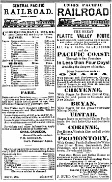
Display ads for the CPRR and UPRR the week the rails were joined on May 10, 1869
When the last spike was driven, the rail network was not yet connected to the Atlantic or Pacific but merely connected Omaha to Sacramento. To get from Sacramento to the Pacific, the Central Pacific purchased the struggling Western Pacific Railroad (unrelated to the railroad of the same name that would later parallel its route) and resumed construction on it, which had halted in 1866 due to funding troubles. In November 1869, the Central Pacific finally connected Sacramento to the east side of San Francisco Bay by rail at Oakland, California, where freight and passengers completed their transcontinental link to the city by ferry.UPRR & CPRR "Great American Over-Land Route" Timetable cover 1881
The original route from the Central Valley to the Bay skirted the Delta by heading south out of Sacramento through Stockton and crossing the San Joaquin River at Mossdale, then climbed over the Altamont Pass and reached the East Bay through Niles Canyon. The Western Pacific was originally chartered to go to San Jose, but the Central Pacific decided to build along the East Bay instead, as going from San Jose up the Peninsula to San Francisco itself would have brought it into conflict with competing interests. The railroad entered Alameda and Oakland from the south, roughly paralleling what would later become U.S. Route 50 and later still Interstates 5, 205, and 580. A more direct route was obtained with the purchase of the California Pacific Railroad, crossing the Sacramento River and proceeding southwest through Davis to Benicia, where it crossed the Carquinez Strait by means of an enormous train ferry, then followed the shores of the San Pablo and San Francisco bays to Richmond and the Port of Oakland (paralleling U.S. Route 40 which ultimately became Interstate 80). In 1930, a rail bridge across the Carquinez replaced the Benicia ferries.
Very early on, the Central Pacific learned that it would have trouble maintaining an open track in winter across the Sierras. At first they tried plowing the road with special snowplows mounted on their steam engines. When this was only partially successful, an extensive process of building snow sheds over some of the track was instituted to protect it from deep snows and avalanches. These eventually succeeded at keeping the tracks clear for all but a few days of the year.[87]
Both railroads soon instituted extensive upgrade projects to build better bridges, viaducts and dugways as well as install heavier duty rails, stronger ties, better road beds etc. The original track had often been laid as fast as possible with only secondary attention to maintenance and durability. The primary incentive had been getting the subsidies, which meant that upgrades of all kinds were routinely required in the following years.
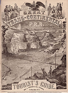
The Union Pacific would not connect Omaha to Council Bluffs until completing the Union Pacific Missouri River Bridge in 1873.Frontispiece of Crofutt's Great Trans-Continental Tourist's Guide, 1870
Several years after the end of the Civil War, the competing railroads coming from Missouri finally realized their initial strategic advantage and a building boom ensued. In July 1869, the H&SJ finished the Hannibal Bridge in Kansas City which was the first bridge to cross the Missouri River. This in turn connected to Kansas Pacific trains going from Kansas City to Denver, which in turn had built the Denver Pacific Railway connecting to the Union Pacific. In August 1870, the Kansas Pacific drove the last spike connecting to the Denver Pacific line at Strasburg, Colorado and the first true Atlantic to Pacific United States railroad was completed.
Kansas City's head start in connecting to a true transcontinental railroad contributed to it rather than Omaha becoming the dominant rail center west of Chicago.
The Kansas Pacific became part of the Union Pacific in 1880.
On June 4, 1876, an express train called the Transcontinental Express arrived in San Francisco via the First Transcontinental Railroad only 83 hours and 39 minutes after it had left New York City. Only ten years before, the same journey would have taken months over land or weeks on ship, possibly all the way around South America.
The Central Pacific got a direct route to San Francisco when it was merged with the Southern Pacific Railroad to create the Southern Pacific Company in 1885. The Union Pacific initially took over the Southern Pacific in 1901 but was forced by the U.S. Supreme Court to divest it because of monopoly concerns. The two railroads would once again unite in 1996 when the Southern Pacific was sold to the Union Pacific.
Having been bypassed with the completion of the Lucin Cutoff in 1904, the Promontory Summit rails were pulled up in 1942 to be recycled for the World War II effort. This process began with a ceremonial "undriving" at the Last Spike location.[88] In 1957, Congress authorized the Golden Spike National Historic Site. On May 10, 2006, on the anniversary of the driving of the spike, Utah announced that its state quarter design would be a representation of the driving of the Last (Golden) Spike.
Crédit Mobilier

Oakes AmesMain article: Crédit Mobilier of America scandalDespite the transcontinental success and millions in government subsidies, the Union Pacific faced bankruptcy less than three years after the Last Spike as details surfaced about overcharges that Crédit Mobilier had billed Union Pacific for the formal building of the railroad. The scandal hit epic proportions in the United States presidential election, 1872, which saw the re-election of Ulysses S. Grant and became the biggest scandal of the Gilded Age. It would not be resolved until the death of the congressman who was supposed to have reined in its excesses but instead wound up profiting from it.
Durant had initially come up with the scheme to have Crédit Mobilier subcontract to do the actual track work. Durant gained control of the company after buying out employee Herbert Hoxie for $10,000. Under Durant's guidance, Crédit Mobilier was charging Union Pacific often twice or more the customary cost for track work (thus in effect paying himself to build the railroad). The process mired down Union Pacific work.
Lincoln asked Massachusetts Congressman Oakes Ames, who was on the railroad committee, to clean things up and get the railroad moving. Ames got his brother Oliver Ames Jr. named president of the Union Pacific, while he himself became president of Crédit Mobilier.[89]
Ames then in turn gave stock options to other politicians while at the same time continuing the lucrative overcharges. The scandal was to implicate Vice President Schuyler Colfax (who was cleared) and future President James Garfield among others.
The scandal broke in 1872 when the New York Sun published correspondence detailing the scheme between Henry S. McComb and Ames. In the ensuing Congressional investigation, it was recommended that Ames be expelled from Congress, but this was reduced to a censure and Ames died within three months.
Durant later left the Union Pacific and a new rail baron Jay Gould became the dominant stockholder. As a result of the Panic of 1873, Gould was able to pick up bargains, among them the control of the Union Pacific Railroad and Western Union.[90]
Visible remains
Visible remains of the historic line are still easily located—hundreds of miles are still in service today, especially through the Sierra Nevada Mountains and canyons in Utah and Wyoming. While the original rail has long since been replaced because of age and wear, and the roadbed upgraded and repaired, the lines generally run on top of the original, handmade grade. Vista points on Interstate 80 through California's Truckee Canyon provide a panoramic view of many miles of the original Central Pacific line and of the snow sheds which made winter train travel safe and practical.
In areas where the original line has been bypassed and abandoned, primarily in Utah, the road grade is still obvious, as are numerous cuts and fills, especially the Big Fill a few miles east of Promontory. The sweeping curve which connected to the east end of the Big Fill now passes a Thiokol rocket research and development facility.
The Last Spike site is preserved as a National Historical Site, with replica engines of Union Pacific No. 119 and Central Pacific Jupiter having been built by O'Connor Engineering Laboratories. The engines are fired up periodically by the National Park Service for the public.[91][92][93][94][95][96][97][98][99]
Current passenger service
Amtrak's California Zephyr, a daily passenger service from Emeryville, California (San Francisco Bay Area) to Chicago, uses the First Transcontinental Railroad from Sacramento central Nevada. Because this rail line currently operates in a directional running setup across most of Nevada, the California Zephyr will switch to the Central Corridor at either Winnemucca or Wells.[100]
In popular culture
The joining of the Union Pacific line with the Central Pacific line in May 1869 at Promontory Summit, Utah, was one of the major inspirations for French writer Jules Verne's book entitled Around the World in Eighty Days, published in 1873.[101]

The feat is depicted in various movies, including the 1939 film Union Pacific, starring Joel McCrea and Barbara Stanwyck and directed by Cecil B. DeMille, which depicts the fictional Central Pacific investor Asa Barrows obstructing attempts of the Union Pacific to reach Ogden, Utah.Poster for the film Union Pacific.
While not exactly accurate, John Ford's 1924 silent movie The Iron Horse captures the fervent nationalism that drove public support for the project. Among the cooks serving the film's cast and crew between shots were some of the Chinese laborers who worked on the Central Pacific section of the railroad.
The 1962 film How the West Was Won has a whole segment devoted to the construction; one of the movie's most famous scenes, filmed in Cinerama, is of a buffalo stampede over the railroad.
The construction of what presumably is – or is suggested to be – the Transcontinental Railroad provides the backdrop of the 1968 epic spaghetti western Once Upon a Time in the West, directed by Italian director Sergio Leone.
Kristiana Gregory's book The Great Railroad Race (part of the "Dear America" series) is written as the fictional diary of Libby West, who chronicles the end of the railroad construction and the excitement which engulfed the country at the time.
Graham Masterton's 1981 novel A Man of Destiny (published in the UK as Railroad) is a fictionalised account of the line's construction.
In the 1999 Will Smith film, Wild Wild West, the joining ceremony is the setting of an assassination attempt on then U.S. President Ulysses S. Grant by the film's antagonist Dr. Miguelito Quixote Loveless.
The building of the railway is covered by the 2004 BBC documentary series Seven Wonders of the Industrial World in episode 6, "The Line".
The series American Experience also documents the railway in the episode titled "Transcontinental Railroad".
The main character in The Claim (2000) is a surveyor for the Central Pacific Railroad, and the film is partially about the efforts of a frontier mayor to have the railroad routed through his town.
The popular British television show Doctor Who featured the Transcontinental Railroad in a BBC audio book entitled The Runaway Train, read by Matt Smith and written for audio by Oli Smith.
The children's book Ten Mile Day by Mary Ann Fraser tells the story of the record setting push by the Central Pacific in which they set a record by laying 10 miles (16 km) of track in a single day on April 28, 1869, to settle a $10,000 bet.
The construction of the Transcontinental Railroad provides the setting for the AMC television series Hell on Wheels. Thomas Durant is a regular character in the series and is portrayed by actor Colm Meaney.
In 2015, a Lego model depicting the Golden Spike Ceremony, the event that symbolically marked the completion of the First Transcontinental Railroad, was submitted to the Lego Ideas website.[102][103]

Wikimedia Commons has media related to First Transcontinental Railroad. See also
- California and the railroads
- Chin Lin Sou
- Hell on Wheels
- Interstate 80 – contemporary New York-to-San Francisco transport link (highway)
- List of heritage railroads in the United States
- Overland Route (Union Pacific Railroad)
- Transcontinental railroad
References
- Vernon, Edward (Ed) "Travelers' Official Railway Guide of the United States and Canada" Philadelphia: The National General Ticket Agents' Association. June, 1870, Tables 215, 216

 Dear readers, time is running out in 2016 to help Wikipedia.
To protect our independence, we'll never run ads. We're sustained by
donations averaging about
Dear readers, time is running out in 2016 to help Wikipedia.
To protect our independence, we'll never run ads. We're sustained by
donations averaging about 


Notes
- The southern route was constructed in 1880 when the Southern Pacific Railroad crossed Arizona territory.
Further reading
- Allen, James B.; Glen M. Leonard (1976). The Story of the Latter-day Saints. Salt Lake City, Utah: Deseret Book Company.
- Ambrose, Stephen E. (2000). Nothing Like It In The World; The men who built the Transcontinental Railroad 1863–1869. Simon & Schuster. ISBN 0-684-84609-8.
- Bain, David Haward (1999). Empire Express; Building the first Transcontinental Railroad. Viking Penguin. ISBN 0-670-80889-X.
- Beebe, Lucius (1969). The Central Pacific & The Southern Pacific Railroads: Centennial Edition. Howell-North. ISBN 0-8310-7034-X.
- Cooper, Bruce C., "Riding the Transcontinental Rails: Overland Travel on the Pacific Railroad 1865–1881" (2005), Polyglot Press, Philadelphia ISBN 1-4115-9993-4
- Cooper, Bruce Clement (Ed), "The Classic Western American Railroad Routes". New York: Chartwell Books/Worth Press, 2010. ISBN 978-0-7858-2573-9; ISBN 0-7858-2573-8; BINC: 3099794.
- Duran, Xavier, "The First U.S. Transcontinental Railroad: Expected Profits and Government Intervention," Journal of Economic History, 73 (March 2013), 177–200.
- Lee, Willis T.; Ralph W. Stone & Hoyt S. Gale (1916). Guidebook of the Western United States, Part B. The Overland Route. USGS Bulletin 612.
- White, Richard. Railroaded: The Transcontinentals and the Making of Modern America (2010)
- Willumson, Glenn. Iron Muse: Photographing the Transcontinental Railroad (University of California Press; 2013) 242 pages; studies the production, distribution, and publication of images of the railroad in the 19th and early 20th centuries.
External links
| Wikimedia Commons has media related to First Transcontinental Railroad. |
- Central Pacific Railroad Photographic History Museum
- CPRR Railroad Map collection/museum
- 1871 CPRR & UPRR Overland Railroad Map "Map of the Central Pacific Railroad and its Connections" published in the California Mail Bag San Francisco News Letter and California Advertiser, Vol. 1, No. 4, Oct–Nov. 1871. accessed May 1, 2013.
- Union Pacific Railroad picture Museum Excursion to the 100th Meridian – 1866 accessed March 1, 2013.
- The Pacific Tourist Williams, Henry T.; published by Adams & Bishop, New York, 1881 ed. Gives insights to travel in the late 1880s on the transcontinental railroad.
- "I Hear the Locomotives: The Impact of the Transcontinental Railroad"
- Golden Spike National Historical Site in Utah
- Central Pacific Railroad Photographic History Museum
- Union Pacific Railroad History
- The Transcontinental Railroad
- Pacific Railway Act and related resources at the Library of Congress
- Chinese-American Contribution to transcontinental railroad
- Booknotes interview with David Haward Bain on Empire Express: Building the First Transcontinental Railroad, March 5, 2000.
- Linda Hall Library's Transcontinental Railroad educational site with free, full-text access to 19th century American railroad periodicals
- Maps
Categories:
- First Transcontinental Railroad
- History of rail transportation in the United States
- Railway lines in the United States
- Southern Pacific Railroad
- Union Pacific Railroad
- American Old West
- History of United States expansionism
- History of the United States (1865–1918)
- Rail lines receiving land grants
- Rail transportation in California
- Rail transportation in Nevada
- Railway lines in Omaha, Nebraska
- Rail transportation in Utah
- 1869 in the United States
- 1860s in California
- Historic Civil Engineering Landmarks

![[6]](https://www.google.com/imgres?imgurl=http://upload.wikimedia.org/wikipedia/commons/6/65/C.P.R.R._train_at_Cape_Horn,_by_Thomas_Houseworth_%2526_Co..jpg&imgrefurl=http://commons.wikimedia.org/wiki/File:C.P.R.R._train_at_Cape_Horn,_by_Thomas_Houseworth_%2526_Co..jpg&h=1419&w=2737&sz=1669&tbnid=8IfJNhakdb9bqM:&tbnh=62&tbnw=120&zoom=1&usg=__R8lvvJNl_a9FCTGufLMRY_6Iz2I=&docid=nJYpVW4BZ669bM&itg=1&hl=en&sa=X&ei=8RU9UdL0GcruyQH-54GoCQ&ved=0CEwQ9QEwAw&dur=166)
No comments:
Post a Comment