Dolomites
From Wikipedia, the free encyclopedia
Etymology
The Dolomites, also known as the "Pale Mountains", take their name from the
carbonate rock dolomite, itself named for 18th-century French
mineralogist Déodat Gratet de Dolomieu (1750–1801), who was the first to describe the mineral.
[2]
History
During the
First World War, the front line between the Italian and
Austro-Hungarian forces ran through the Dolomites, where
mines
were used extensively. There are now open-air war museums at Cinque
Torri (Five Towers) and Mount Lagazuoi. Many people visit the Dolomites
to climb the
vie ferrate, protected paths created during the war.
A number of long-distance footpaths traverse the Dolomites. They are called
alte vie (high paths), and are numbered from 1 to 8. The trails take on the order of a week to walk, and are served by numerous
rifugi (huts). The first and perhaps most renowned is the
Alta Via 1.
Radiocarbon dating has been used in the Alta Badia region to
demonstrate a connection between landslide activity and climate change.
[3]
Geography
The
region is commonly divided into the Western and Eastern Dolomites,
separated by a line following the Val Badia – Campolongo Pass –
Cordevole Valley (Agordino) axis.
Current classification
The Dolomites may be divided into the following ranges:
Tourism
The Dolomites are renowned for
skiing in the winter months and
mountain climbing, hiking, cycling, and
BASE jumping, as well as paragliding and hang gliding in summer and late spring/early autumn.
[citation needed] Free climbing has been a tradition in the Dolomites since 1887, when 17-year-old Georg Winkler soloed the first ascent of the pinnacle
Die Vajolettürme.
[4] The main centres include:
Rocca Pietore alongside the
Marmolada Glacier, which lies on the border of Trentino and Veneto, the small towns of
Alleghe,
Falcade,
Auronzo,
Cortina d'Ampezzo and the villages of
Arabba,
Urtijëi and
San Martino di Castrozza, as well as the whole of the Fassa, Gardena and Badia valleys.
The
Maratona dles Dolomites,
an annual single-day road bicycle racing race covering seven mountain
passes of the Dolomites, occurs in the first week of July.
Other characteristic places are:
Major peaks

| Marmolada |
3,343 |
10,968 |
Pala di San Martino |
2,982 |
9,831 |
| Antelao |
3,264 |
10,706 |
Rosengartenspitze / Catinaccio |
2,981 |
9,781 |
| Tofana di Mezzo |
3,241 |
10,633 |
Cima di Fradusta |
2,941 |
9,715 |
| Sorapiss |
3,229 |
10,594 |
Cimon del Froppa |
2,932 |
9,649 |
| Cristallo |
3,221 |
10,568 |
Monte Agnèr |
2,872 |
9,416 |
| Monte Civetta |
3,220 |
10,564 |
Fermedaturm |
2,867 |
9,407 |
| Cima di Vezzana |
3,192 |
10,470 |
Cima d'Asta |
2,848 |
9,344 |
| Cimon della Pala |
3,184 |
10,453 |
Cima di Canali |
2,846 |
9,338 |
| Langkofel / Sassolungo |
3,181 |
10,427 |
Croda Grande |
2,839 |
9,315 |
| Monte Pelmo |
3,168 |
10,397 |
Vajoletturm / Torri del Vajolet (highest) |
2,821 |
9,256 |
| Dreischusterspitze |
3,162 |
10,375 |
Sass Maor |
2,816 |
9,239 |
| Boespitze / Piz Boè (Sella group) |
3,152 |
10,342 |
Cima di Ball |
2,783 |
9,131 |
| Hohe Gaisl (Croda Rossa d'Ampezzo) |
3,148 |
10,329 |
Cima della Madonna (Sass Maor) |
2,751 |
9,026 |
| Vernel |
3,145 |
10,319 |
Rosetta |
2,741 |
8,993 |
| Piz Popena |
3,143 |
10,312 |
Croda da Lago |
2,716 |
8,911 |
| Grohmannspitze (Langkofel) |
3,126 |
10,256 |
Central Grasleitenspitze |
2,705 |
8,875 |
| Zwölferkofel |
3,094 |
10,151 |
Schlern |
2,562 |
8,406 |
| Elferkofel |
3,092 |
10,144 |
Sasso di Mur |
2,554 |
8,380 |
| Sass Rigais (Geislerspitzen) |
3,025 |
9,925 |
Cima delle Dodici |
2,338 |
7,671 |
| Kesselkogel (Rosengarten) |
3,004 |
9,856 |
Monte Pavione |
2,336 |
7,664 |
| Tre Cime di Lavaredo (Drei Zinnen) |
2,999 |
9,839 |
Cima Palon |
2,239 |
7,346 |
| Fünffingerspitze |
2,997 |
9,833 |
Cima di Posta |
2,235 |
7,333 |
Major passes

| Ombretta Pass (Campitello to Caprile), foot path |
2,738 |
8,983 |
| Langkofeljoch (Gröden Valley to Campitello), foot path |
2,683 |
8,803 |
| Tschagerjoch (Karersee to the Vajolet Glen), foot path |
2,644 |
8,675 |
| Grasleiten Pass (Vajolet Glen to the Grasleiten Glen), foot path |
2,597 |
8,521 |
| Pravitale Pass (Rosetta Plateau to the Pravitale Glen), foot path |
2,580 |
8,465 |
| Comelle Pass (same to Cencenighe), foot path |
2,579 |
8,462 |
| Rosetta Pass (San Martino di Castrozza to the great limestone Rosetta plateau), foot path |
2,573 |
8,442 |
| Vajolet Pass (Tiers to the Vajolet Glen), foot path |
2,549 |
8,363 |
| Canali Pass (Primiero to Agordo), foot path |
2,497 |
8,193 |
| Tierseralpljoch (Campitello to Tiers), foot path |
2,455 |
8,055 |
| Ball Pass (San Martino di Castrozza to the Pravitale Glen), foot path |
2,450 |
8,038 |
| Forcella di Giralba (Sexten to Auronzo), foot path |
2,436 |
7,992 |
| Col dei Bos (Falzarego Glen to the Travernanzes Glen), foot path |
2,313 |
7,589 |
| Forcella Grande (San Vito to Auronzo), foot path |
2,262 |
7,422 |
| Pordoi Pass (Arabba to Val di Fassa), road |
2,250 |
7,382 |
| Sella Pass (Gröden Valley to Val di Fassa), road |
2,244 |
7,362 |
| Giau Pass (Cortina to Val Fiorentina), road |
2,236 |
7,336 |
| Tre Sassi Pass (Cortina to St Cassian), foot path |
2,199 |
7,215 |
| Valparola Pass (Cortina to St Cassian), road |
2,168 |
7,113 |
| Mahlknechtjoch (Upper Duron Glen to the Seiser Alp), foot path |
2,168 |
7,113 |
| Gardena Pass (Gröden Valley to Colfuschg), road |
2,121 |
6,959 |
| Falzarego Pass (Caprile to Cortina), road |
2,117 |
6,946 |
| Fedaja Pass (Val di Fassa to Caprile), bridle path |
2,046 |
6,713 |
| Valles Pass (Paneveggio to Falcade), road |
2,032 |
6,667 |
| Würzjoch (Eisacktal to Val Badia), road |
2,003 |
6,572 |
| Rolle Pass (Predazzo to San Martino di Castrozza and Primiero), road |
1,984 |
6,509 |
| Forcella Forada (Caprile to San Vito), bridle path |
1,975 |
6,480 |
| San Pellegrino Pass (Moena to Cencenighe), road |
1,910 |
6,267 |
| Campolongo Pass (Corvara to Arabba), road |
1,875 |
6,152 |
| Forcella d'Alleghe (Alleghe to the Zoldo Glen), foot path |
1,820 |
5,971 |
| Tre Croci Pass (Cortina to Auronzo), road |
1,808 |
5,932 |
| Furkel Pass (Mareo to Olang), road |
1,759 |
5,771 |
| Karerpass or Costalunga Pass (Welschnofen to Vigo di Fassa), road |
1,753 |
5,751 |
| Kreuzbergpass or Monte Croce Pass (Innichen and Sexten to the Piave Valley and Belluno), road |
1,638 |
5,374 |
| Ampezzo Pass (Toblach to Cortina and Belluno), path |
1,544 |
5,066 |
| Cereda Pass (Primiero to Agordo), road |
1,372 |
4,501 |
| Toblach Pass (Bruneck to Lienz), railway |
1,209 |
3,967 |
Major parks
|
|
|
- Naturpark Puez-Geisler 10,196 ha (102 km2)
- Parco naturale provinciale dell' Adamello-Brenta 153,320 acres (620.5 km2)
- Parco naturale regionale delle Dolomiti Friulane
|
Panoramic view
360° panoramic view from Marmolada, highest peak in the Dolomites
See also
References
 View from Pordoi
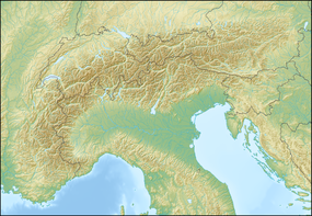
 DolomitesLocation of the Dolomites in the Alps


 Location of Dolomites
 View of the Dolomites
 Winter view of the Sella Group


 360° panoramic view from Marmolada, highest peak in the Dolomites


 This article incorporates text from a publication now in the public domain: Chisholm, Hugh, ed. (1911). "Dolomites, The". Encyclopædia Britannica. 8 (11th ed.). Cambridge University Press. p. 394.
No comments:
Post a Comment