
 Associated Press

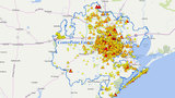
Check bayou levels, rainfall totals across Houston area

Rising creeks and bayous are a concern for many residents, and you can check bayou levels at the Harris County Flood Warning System website at www.harriscountyfws.org.
More Weather Headlines
-
Deadly Harvey pounds SE Texas with catastrophic flooding
- WEATHER ALERT: Warnings, watches issued for area counties
- High water locations in Houston area
- Harvey's landfall just the start of growing weather concerns for Houston
- Power outages reported across Houston area
- Tracking Harvey: County, city government cancellations
- Tracking Harvey: School delays, closures
- Tornado touches down in Sienna Plantation
A green square means the bayou is still in its banks. A yellow triangle with an exclamation point means the bayou is nearing being out of bank. And a red circle with an exclamation point means the bayou is over the top of its bank.
The site also has rainfall totals for Harris County. Just click/tap on Rainfall under Map View Options.
As of early Saturday morning, the following is a list of area bayou conditions from the Harris County Flood Control District:
The following is a list of area bayous currently being affected:
- Beamer Ditch
- Turkey Creek
- Berry Bayou
- Little Vince Bayou
- Vince Bayou
- Armand Bayou
- Hunting Bayou
- Langham Creek
- Clear Creek
- Halls Bayou
- Greens Bayou
- Brays Bayou
- Keegans Bayou
- Little Cypress Creek
- Horsepen Creek
- South Mayde Creek
- West Fork San Jacinto River
The HCFCD said the U.S. Army Corps of Engineers is monitoring the Addicks and Barker dams and reservoirs. Both outlet gates were closed at 8 p.m. Friday and will remain closed until the rain threat stops.
The Clear Creek Second Outlet gates were also closed on Friday afternoon, according to HCFCD.

No comments:
Post a Comment