I'm watching the wind whip the trees and luckily so far no branches or trees have come down into our yard or trees from neighbors haven't crashed through our fences so far. However, the clock on the stove demonstrated we had a power outage (even if it was momentarily at some point so I reset it. So, I'm glad I got our gasoline generator working if we need it and have some wood by the fire place if I need to light it too.
Like I said it started raining lightly by Midnight my wife said but it didn't rain hard enough on the skylight above our bed to wake me up until 5 am but then again my wife is a light sleeper, especially after our daughter was born in the 1990s.
The wind is starting to howl more now like the weather man said it would in the afternoon. So, we will hope for the best for ourselves and all our neighbors regarding branches and trees that might come down now.
Our daughter's corgi likes to go outside now and just stare at everything. They say dogs don't know about what death is but she is nearing the end. Her Back right leg collapses more on her and I'm having to carry her out to do her business and back in more and more. If we let her she would just stay outside and stare at the sky for hours but it is too cold, and windy and rainy to let her do that today. Yesterday mostly it was sunny still. She's about 14 1/2 years old which is pretty old for a Corgi. But, from a distance she still doesn't look that old and is very sweet still.
I think we just got some Hail, but it seldom here is bigger than the tip of your little finger. But, it was pretty loud. When I looked out on the deck there were some ice pieces there so I'm certain now we got hail.
Hail - Wikipedia
https://en.wikipedia.org/wiki/Hail
| Hailstorm | |
|---|---|
| Sign | Chunks of ice falling from the sky, during a rainstorm or thunderstorm. |
| Type | Severe |
| Cloud of origin | Cumulonimbus |
| Effect | Extreme damage, dents in metal |
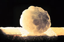
A large hailstone, about 6 cm (2.4 in) in diameter
Unlike other forms of water ice such as graupel, which is made of rime, and ice pellets, which are smaller and translucent, hailstones usually measure between 5 millimetres (0.2 in) and 15 centimetres (6 in) in diameter. The METAR reporting code for hail 5 mm (0.20 in) or greater is GR, while smaller hailstones and graupel are coded GS.
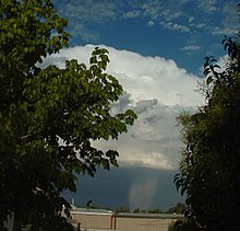
Hail is possible within most thunderstorms as it is produced by cumulonimbus,[3] and within 2 nautical miles (3.7 km) of the parent storm. Hail formation requires environments of strong, upward motion of air with the parent thunderstorm (similar to tornadoes) and lowered heights of the freezing level. In the mid-latitudes, hail forms near the interiors of continents, while in the tropics, it tends to be confined to high elevations.
There are methods available to detect hail-producing thunderstorms using weather satellites and weather radar imagery. Hailstones generally fall at higher speeds as they grow in size, though complicating factors such as melting, friction with air, wind, and interaction with rain and other hailstones can slow their descent through Earth's atmosphere. Severe weather warnings are issued for hail when the stones reach a damaging size, as it can cause serious damage to human-made structures and, most commonly, farmers' crops.
Contents
Definition
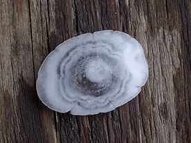
Any thunderstorm which produces hail that reaches the ground is known as a hailstorm.[4] Hail has a diameter of 5 millimetres (0.20 in) or more.[3] Hailstones can grow to 15 centimetres (6 in) and weigh more than 0.5 kilograms (1.1 lb).[5]Unlike ice pellets, hailstones are layered and can be irregular and clumped together. Hail is composed of transparent ice or alternating layers of transparent and translucent ice at least 1 millimetre (0.039 in) thick, which are deposited upon the hailstone as it travels through the cloud, suspended aloft by air with strong upward motion until its weight overcomes the updraft and falls to the ground. Although the diameter of hail is varied, in the United States, the average observation of damaging hail is between 2.5 cm (1 in) and golf ball-sized (1.75 in).[6]
Stones larger than 2 cm (0.80 in) are usually considered large enough to cause damage. The Meteorological Service of Canada issues severe thunderstorm warnings when hail that size or above is expected.[7] The US National Weather Service has a 2.5 cm (1 in) or greater in diameter threshold, effective January 2010, an increase over the previous threshold of ¾-inch hail.[8] Other countries have different thresholds according local sensitivity to hail; for instance grape growing areas could be adversely impacted by smaller hailstones. Hailstones can be very large or very small, depending on how strong the updraft is: weaker hailstorms produce smaller hailstones than stronger hailstorms (such as supercells).
Formation
Hail forms in strong thunderstorm clouds, particularly those with intense updrafts, high liquid water content, great vertical extent, large water droplets, and where a good portion of the cloud layer is below freezing 0 °C (32 °F).[3] These types of strong updrafts can also indicate the presence of a tornado.[9] The growth rate is maximized where air is near a temperature of −13 °C (9 °F).[citation needed]Layer nature of the hailstones
Hail shaft
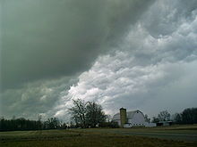
Severe thunderstorms containing hail can exhibit a characteristic green coloration[10]
The storm's updraft, with upwardly directed wind speeds as high as 110 miles per hour (180 km/h),[11] blows the forming hailstones up the cloud. As the hailstone ascends it passes into areas of the cloud where the concentration of humidity and supercooled water droplets varies. The hailstone’s growth rate changes depending on the variation in humidity and supercooled water droplets that it encounters. The accretion rate of these water droplets is another factor in the hailstone’s growth. When the hailstone moves into an area with a high concentration of water droplets, it captures the latter and acquires a translucent layer. Should the hailstone move into an area where mostly water vapour is available, it acquires a layer of opaque white ice.[12]
Furthermore, the hailstone’s speed depends on its position in the cloud’s updraft and its mass. This determines the varying thicknesses of the layers of the hailstone. The accretion rate of supercooled water droplets onto the hailstone depends on the relative velocities between these water droplets and the hailstone itself. This means that generally the larger hailstones will form some distance from the stronger updraft where they can pass more time growing.[12] As the hailstone grows it releases latent heat, which keeps its exterior in a liquid phase. Because it undergoes 'wet growth', the outer layer is sticky (i.e. more adhesive), so a single hailstone may grow by collision with other smaller hailstones, forming a larger entity with an irregular shape.[13]
Hail can also undergo 'dry growth' in which the latent heat release through freezing is not enough to keep the outer layer in a liquid state. Hail forming in this manner appears opaque due to small air bubbles that become trapped in the stone during rapid freezing. These bubbles coalesce and escape during the 'wet growth' mode, and the hailstone is more clear. The mode of growth for a hailstone can change throughout its development, and this can result in distinct layers in a hailstone's cross-section.[14]
The hailstone will keep rising in the thunderstorm until its mass can no longer be supported by the updraft. This may take at least 30 minutes based on the force of the updrafts in the hail-producing thunderstorm, whose top is usually greater than 10 km high. It then falls toward the ground while continuing to grow, based on the same processes, until it leaves the cloud. It will later begin to melt as it passes into air above freezing temperature.[15]
Thus, a unique trajectory in the thunderstorm is sufficient to explain the layer-like structure of the hailstone. The only case in which multiple trajectories can be discussed is in a multicellular thunderstorm, where the hailstone may be ejected from the top of the "mother" cell and captured in the updraft of a more intense "daughter" cell. This, however, is an exceptional case.[12]
Factors favoring hail
Hail is most common within continental interiors of the mid-latitudes, as hail formation is considerably more likely when the freezing level is below the altitude of 11,000 feet (3,400 m).[16] Movement of dry air into strong thunderstorms over continents can increase the frequency of hail by promoting evaporational cooling which lowers the freezing level of thunderstorm clouds giving hail a larger volume to grow in. Accordingly, hail is less common in the tropics despite a much higher frequency of thunderstorms than in the mid-latitudes because the atmosphere over the tropics tends to be warmer over a much greater altitude. Hail in the tropics occurs mainly at higher elevations.[17]Hail growth becomes vanishingly small when air temperatures fall below −30 °C (−22 °F) as supercooled water droplets become rare at these temperatures.[16] Around thunderstorms, hail is most likely within the cloud at elevations above 20,000 feet (6,100 m). Between 10,000 feet (3,000 m) and 20,000 feet (6,100 m), 60 percent of hail is still within the thunderstorm, though 40 percent now lies within the clear air under the anvil. Below 10,000 feet (3,000 m), hail is equally distributed in and around a thunderstorm to a distance of 2 nautical miles (3.7 km).[18]
Climatology
Hail occurs most frequently within continental interiors at mid-latitudes and is less common in the tropics, despite a much higher frequency of thunderstorms than in the mid-latitudes.[19] Hail is also much more common along mountain ranges because mountains force horizontal winds upwards (known as orographic lifting), thereby intensifying the updrafts within thunderstorms and making hail more likely.[20] The higher elevations also result in there being less time available for hail to melt before reaching the ground. One of the more common regions for large hail is across mountainous northern India, which reported one of the highest hail-related death tolls on record in 1888.[21] China also experiences significant hailstorms.[22] Central Europe and southern Australia also experience a lot of hailstorms. Popular regions for hailstorms are southern and western Germany, northern and eastern France and southern and eastern Benelux. In south-eastern Europe, Croatia and Serbia experience frequent occurrences of hail.[23]In North America, hail is most common in the area where Colorado, Nebraska, and Wyoming meet, known as "Hail Alley".[24] Hail in this region occurs between the months of March and October during the afternoon and evening hours, with the bulk of the occurrences from May through September. Cheyenne, Wyoming is North America's most hail-prone city with an average of nine to ten hailstorms per season.[25] To the north of this area and also just downwind of the Rocky Mountains is the Hailstorm Alley region of Alberta, which also experiences an increased incidence of significant hail events.
Short-term detection
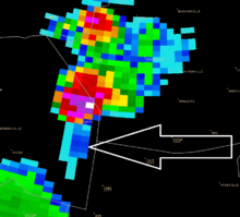
Example of a three body spike: the weak triangular echoes (pointed by
the arrow) behind the red and white thunderstorm core are related to
hail inside the storm.
Modern radar scans many angles around the site. Reflectivity values at multiple angles above ground level in a storm are proportional to the precipitation rate at those levels. Summing reflectivities in the Vertically Integrated Liquid or VIL, gives the liquid water content in the cloud. Research shows that hail development in the upper levels of the storm is related to the evolution of VIL. VIL divided by the vertical extent of the storm, called VIL density, has a relationship with hail size, although this varies with atmospheric conditions and therefore is not highly accurate.[26] Traditionally, hail size and probability can be estimated from radar data by computer using algorithms based on this research. Some algorithms include the height of the freezing level to estimate the melting of the hailstone and what would be left on the ground.
Certain patterns of reflectivity are important clues for the meteorologist as well. The three body scatter spike is an example. This is the result of energy from the radar hitting hail and being deflected to the ground, where they deflect back to the hail and then to the radar. The energy took more time to go from the hail to the ground and back, as opposed to the energy that went direct from the hail to the radar, and the echo is further away from the radar than the actual location of the hail on the same radial path, forming a cone of weaker reflectivities.
More recently, the polarization properties of weather radar returns have been analyzed to differentiate between hail and heavy rain.[27][28] The use of differential reflectivity (
 ), in combination with horizontal reflectivity (
 ) has led to a variety of hail classification algorithms.[29] Visible satellite imagery is beginning to be used to detect hail, but false alarm rates remain high using this method.[30]
Size and terminal velocity
Hailstones ranging in size from few millimetres to over a centimetre in diameter.
Large hailstone with concentric rings
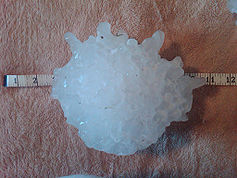
The largest recorded hailstone in the United States by diameter 7.9
inches (20 cm) and weight 1.94 pounds (0.88 kg). The hailstone fell in
Vivian, South Dakota on July 23, 2010.
Hail records
Megacryometeors, large rocks of ice that are not associated with thunderstorms, are not officially recognized by the World Meteorological Organization as "hail," which are aggregations of ice associated with thunderstorms, and therefore records of extreme characteristics of megacryometeors are not given as hail records.- Heaviest: 1.02 kg (2.25 lb); Gopalganj District, Bangladesh, 14 April 1986.[34][35]
- Largest diameter officially measured: 7.9 inches (20 cm) diameter, 18.622 inches (47.3 cm) circumference; Vivian, South Dakota, 23 July 2010.[36]
- Largest circumference officially measured: 18.74 inches (47.6 cm) circumference, 7.0 inches (17.8 cm) diameter; Aurora, Nebraska, 22 June 2003.[35][37]
- Greatest average hail precipitation: Kericho, Kenya experiences hailstorms, on average, 50 days annually. Kericho is close to the equator and the elevation of 7,200 feet contributes to it being a hot spot for hail.[38] Kericho reached the world record for 132 days of hail in one year.[39]
Hazards
Hail can cause serious damage, notably to automobiles, aircraft, skylights, glass-roofed structures, livestock, and most commonly, farmers' crops.[25] Hail damage to roofs often goes unnoticed until further structural damage is seen, such as leaks or cracks. It is hardest to recognize hail damage on shingled roofs and flat roofs, but all roofs have their own hail damage detection problems.[41] Metal roofs are fairly resistant to hail damage, but may accumulate cosmetic damage in the form of dents and damaged coatings.[42]Hail is one of the most significant thunderstorm hazards to aircraft.[43] When hailstones exceed 0.5 inches (13 mm) in diameter, planes can be seriously damaged within seconds.[44] The hailstones accumulating on the ground can also be hazardous to landing aircraft. Hail is also a common nuisance to drivers of automobiles, severely denting the vehicle and cracking or even shattering windshields and windows. Wheat, corn, soybeans, and tobacco are the most sensitive crops to hail damage.[21] Hail is one of Canada's most expensive hazards.[45] Rarely, massive hailstones have been known to cause concussions or fatal head trauma. Hailstorms have been the cause of costly and deadly events throughout history. One of the earliest known incidents occurred around the 9th century in Roopkund, Uttarakhand, India, where 200 to 600 nomads seem to have died of injuries from hail the size of cricket balls.[46] The largest hailstone in terms of diameter and weight ever recorded in the United States fell on July 23, 2010 in Vivian, South Dakota; it measured 8 inches (20 cm) in diameter and 18.62 inches (47.3 cm) in circumference, weighing in at 1.93 pounds (0.88 kg).[47] This broke the previous record for diameter set by a hailstone 7 inches diameter and 18.74 inches circumference (still the greatest circumference hailstone) which fell in Aurora, Nebraska in the United States on June 22, 2003, as well as the record for weight, set by a hailstone of 1.67 pounds (0.76 kg) that fell in Coffeyville, Kansas in 1970.[47]
Accumulations
Accumulated hail after a storm in Charlton, Massachusetts
Depths of up to 18 in (0.46 m) have been reported. A landscape covered in accumulated hail generally resembles one covered in accumulated snow and any significant accumulation of hail has the same restrictive effects as snow accumulation, albeit over a smaller area, on transport and infrastructure.[51] Accumulated hail can also cause flooding by blocking drains, and hail can be carried in the floodwater, turning into a snow-like slush which is deposited at lower elevations.
On somewhat rare occasions, a thunderstorm can become stationary or nearly so while prolifically producing hail and significant depths of accumulation do occur; this tends to happen in mountainous areas, such as the July 29, 2010 case[52] of a foot of hail accumulation in Boulder County, Colorado. On June 5, 2015, hail up to four feet deep fell on one city block in Denver, Colorado. The hailstones, described as between the size of bumble bees and ping pong balls, were accompanied by rain and high winds. The hail fell in only the one area, leaving the surrounding area untouched. It fell for one and a half hours between 10 p.m. and 11:30 p.m. A meteorologist for the National Weather Service in Boulder said, "It's a very interesting phenomenon. We saw the storm stall. It produced copious amounts of hail in one small area. It's a meteorological thing." Tractors used to clear the area filled more than 30 dump-truck loads of hail.[53]
Research focused on four individual days that accumulated more than 5.9 inches (15 cm) of hail in 30 minutes on the Colorado front range has shown that these events share similar patterns in observed synoptic weather, radar, and lightning characteristics,[54] suggesting the possibility of predicting these events prior to their occurrence. A fundamental problem in continuing research in this area is that, unlike hail diameter, hail depth is not commonly reported. The lack of data leaves researchers and forecasters in the dark when trying to verify operational methods. A cooperative effort between the University of Colorado and the National Weather Service is in progress. The joint project's goal is to enlist the help of the general public to develop a database of hail accumulation depths.[55]
Suppression and prevention
Hail cannon in an old castle in Banska Stiavnica, Slovakia
See also
References
- Abshaev, M.T., A.M. Abshaev and Malkarova A.M. (2012) "Estimation of antihail projects efficiency considering the tendency of hail climatology change". 10th WMO Conf. Weather Mod. – Bali, Indonesia. WWRP 2012-2, pp. 1–4.
Further reading
- Rogers and Yau (1989). A Short Course in CLOUD PHYSICS. Massachusetts: Butterworth-Heinemann. ISBN 0-7506-3215-1.
- Jim Mezzanotte (2007). Hailstorms. Gareth Stevens Publishing. ISBN 978-0-8368-7912-4.
- Snowden Dwight Flora (2003). Hailstorms of the United States. Textbook Publishers. ISBN 978-0-7581-1698-7.
- Narayan R. Gokhale (1974). Hailstorms and Hailstone Growth. State University of New York Press. ISBN 978-0-87395-313-9.
- Duncan Scheff (2001). Ice and Hailstorms. Raintree Publishers. ISBN 978-0-7398-4703-9.
External links
| Wikimedia Commons has media related to Hail. |
| Look up Hail or hail in Wiktionary, the free dictionary. |
| Wikisource has the text of the 1879 American Cyclopædia article Hail. |




No comments:
Post a Comment