Intuitive fred888

To the best of my ability I write about my experience of the Universe Past, Present and Future

Tuesday, December 26, 2023

Treacherous travel underway as blizzard conditions and ice blast parts of central US

begin quote from:

https://www.cnn.com/2023/12/26/weather/blizzard-nebraska-south-dakota-tuesday/index.html

Treacherous travel underway as blizzard conditions and ice blast parts of central US

By Nouran Salahieh and Mary Gilbert, CNN
3 minute read
Updated 1:46 PM EST, Tue December 26, 2023
Idalia gas station thumb 2
See gas station roof ripped off as Hurricane Idalia rips through Florida
00:30
tree falls on home
Woman captures dramatic moment tree collapses onto her home
00:33
st elmo's fire thumb 1
Pilots capture rare footage of lightning-like electrical phenomena
00:35
idalia 9a graphic cnn weather vpx thumb
Hilary forces swift water rescues with catastrophic flooding
02:28
nebraska crash thumbnail lon orig na
See how winter storm wreaked havoc on Nebraska highway
00:30
Derek Van Dam
See the location CNN meteorologist is concerned about during storm
01:50
Hurricane Otis vpx
Drone footage shows widespread devastation caused by Category 5 hurricane
02:24
zip line sikkim
Himalayan village is cut off by floodwaters. See locals send supplies in
00:39
bk flood thumb
Watch: Heavy rains cause flooding throughout NYC
00:47
Georgia Flood Rescue SCREENGRAB
Police bodycam captures rescue in waist-high floodwaters
02:46
A car is driven along the A670 in snow near the village of Diggle, east of Manchester in northern England on March 18, 2018, as the wintry weather makes a return to the country.
The Met Office has weather warnings in place for the UK as some areas expect up to 25cm of snow to fall on Sunday. / AFP PHOTO / Oli SCARFF        (Photo credit should read OLI SCARFF/AFP/Getty Images)
How to survive winter weather in your car
01:16
CAMARILLO, CA - MAY 3:  A man on a rooftop looks at approaching flames as the Springs fire continues to grow on May 3, 2013 near Camarillo, California. The wildfire has spread to more than 18,000 acres on day two and is 20 percent contained.  (Photo by David McNew/Getty Images)
What's the weather forecast for 2050?
04:18
van dam steering snow
Driving instructor demonstrates how to steer in the snow
01:29
car flips tornado
Tornado sends car flying on highway
00:29
Idalia Florida Kaye vpx 4
See the devastating aftermath Idalia left throughout Florida
02:27
Idalia gas station thumb 2
See gas station roof ripped off as Hurricane Idalia rips through Florida
00:30
tree falls on home
Woman captures dramatic moment tree collapses onto her home
00:33
st elmo's fire thumb 1
Pilots capture rare footage of lightning-like electrical phenomena
00:35
idalia 9a graphic cnn weather vpx thumb
Hilary forces swift water rescues with catastrophic flooding
02:28
nebraska crash thumbnail lon orig na
See how winter storm wreaked havoc on Nebraska highway
00:30
Derek Van Dam
See the location CNN meteorologist is concerned about during storm
01:50
Hurricane Otis vpx
Drone footage shows widespread devastation caused by Category 5 hurricane
02:24
zip line sikkim
Himalayan village is cut off by floodwaters. See locals send supplies in
00:39
CNN  — 

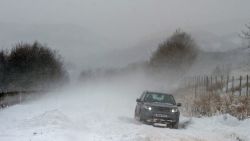
A blizzard-fueling winter storm is sweeping across the Plains and upper Midwest with heavy snow, freezing rain and strong winds, making for dangerous travel during the busy holiday week.

The storm will generate frequent wind gusts of 50 to 60 mph with isolated gusts up to 75 mph Tuesday, which could topple trees and power lines, and bring blizzard conditions that make travel “difficult to near impossible,” the National Weather Service said.

Parts of Nebraska, South Dakota, Kansas, Colorado and Wyoming are under blizzard warnings Tuesday. Blizzards occur when blowing snow and sustained strong winds combine for at least three hours and reduce visibility to a quarter-mile or less.

ADVERTISING

“Widespread travel disruptions are likely across the region,” the weather service warned. Residents were cautioned to avoid travel, but if they must be on the road, to bring survival kits and stay in their vehicles in case they get stranded.

Planes parked on the tarmac as heavy rain falls on the airport in Hong Kong on Tuesday morning, July 24, 2012. Planes grounded at the financial capital's international airport were buffeted by the high winds from Typhoon Vicente early Tuesday. Passengers were told the conditions were expected to last several hours. (AP Photo/ Ng Han Guan)

The weather most likely to ruin your flight plans

An additional six inches or more of snow are possible for portions of South Dakota, Nebraska and Wyoming on Tuesday. Two-day snowfall totals from Monday through Tuesday could exceed a foot in spots.

For some areas, the main winter weather threat shifted from snow to ice on Tuesday.

A mix of sleet and freezing rain could cause scattered power outages and make for dangerously icy roads and sidewalks in parts of the northern Plains and upper Midwest on Tuesday. Portions of the Dakotas and Minnesota are under ice storm warnings through Tuesday evening.

Residents in 14 North Dakota counties are being advised to avoid all travel Tuesday because of poor winter road conditions, the state’s Department of Transportation announced. Westbound lanes of about 50 miles of Interstate 94 in the state were closed Tuesday morning due to “multiple traffic incidents.”

The storm will begin to wind down Tuesday night across the central US and lose most of its potency early Wednesday. A few snow showers or a mix of rain and wet snow may linger for the Plains, but widespread, disruptive weather will come to an end midweek.

Accidents and road closures began on Christmas Day

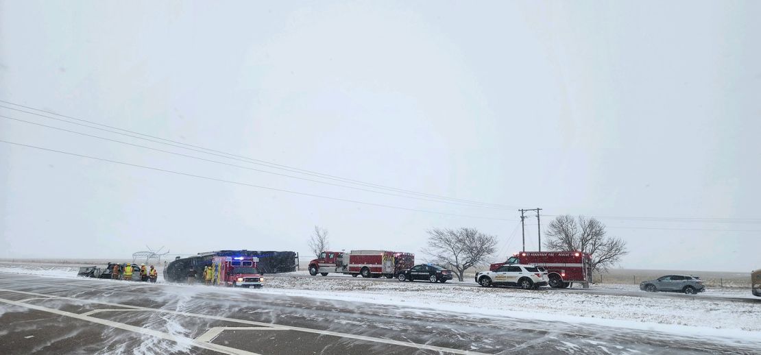
Treacherous conditions began on Monday for portions of the central US as the storm dumped a dangerous mix of snow, ice and strong winds.

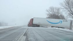
Cars collided and slid off roads Monday in Nebraska, where tractor-trailers jackknifed and got stuck on eastbound Interstate 80 near York in the morning and early afternoon, the Nebraska State Patrol said.

Per Nebraska State Patrol:
The storm is causing issues on the roads on this Christmas morning. Slick driving conditions and blowing snow continue in many areas of the state. 

These photos are all from between Grand Island and Lincoln on I-80.

Great day to stay inside if travel isnít necessary.
Nebraska first responders work along a slick I-80 on Monday between Grand Island and Lincoln.
Nebraska State Patrol

Farther north, heavy snowfall slammed the Dakotas. In South Dakota, I-90 was closed in both directions from Monday night through Tuesday morning for a more than 200-mile stretch between Mitchell and Wall, the South Dakota Department of Transportation said.

Eastbound lanes between Wall and Rapid City – about 50 miles – were also closed, the department said. The westbound lanes were expected to remain open Tuesday “unless weather and road conditions change.”

“Motorists should not use secondary highways to avoid Interstate closures. Significantly reduced visibilities and blizzard-like conditions will make travel very dangerous during this storm system,” the department said.

The South Dakota Highway Patrol said it responded to several crashes in Watertown as ice and snow blanketed roadways.

“Please slow down, don’t use your cruise control, and always wear your seatbelt. Snow plows are out, please give them room to work,” the South Dakota Highway Patrol urged residents.

CNN Meteorologist Robert Shackelford and CNN’s Alaa Elassar, Andy Rose and Dave Alsup contributed to this report.

intuitivefred888 at 11:34 AM
Share

No comments:

Post a Comment

‹
›
Home
View web version

About Me

intuitivefred888
I live in Coastal Northern California at present but was raised mostly in Los Angeles and San Diego Counties. I have also lived in Seattle, Santa Fe, New Mexico, Maui and the big Island of Hawaii. My archive site is: dragonofcompassion.com
View my complete profile
Powered by Blogger.