begin quote from:
https://www.cnn.com/2024/01/05/weather/northeast-snow-winter-storm-friday-climate/index.html
The Northeast and mid-Atlantic are in for an icy, snowy weekend as winter storm looms


A winter storm is gearing up to deal a blow of heavy snow and treacherous ice to the Northeast and mid-Atlantic this weekend.
Here are the latest developments:
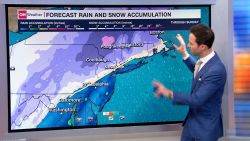
Around 25 million people are under winter storm alerts from the mid-Atlantic to the Appalachians and into southern Maine, with the storm’s worst expected Saturday to Sunday in parts of the Appalachians and the interior Northeast and New England, including just to the west of Boston.
Interactive: Check to see if you’re under a winter weather alert here.
Most of the major cities along the Northeast’s I-95 corridor appear set to miss out on heavy snow, but by the time the storm exits the coast, it could have wrung out as much as 12 inches of snow and as much as 0.25 inches of ice across the eastern US.
On Friday, the storm was spitting out rain in eastern Texas and Louisiana and lighter snow to the north in parts of the Plains and Midwest.
The system will continue to track through the Southeast and into the mid-Atlantic Friday into Saturday, delivering heavy rain and even the threat of a few severe storms along the Gulf Coast.
Potentially damaging ice could accumulate in the southern Appalachians Friday night into Saturday morning as the storm starts to work its way into colder air. Travel in these regions could be treacherous, especially in hilly and mountainous terrain, as ice sticks to surfaces.
City-by-city look at snow, ice
It appears there won’t be sufficient cold air to churn out much, if any, snow in the snow-starved I-95 corridor.
But other cities, especially in New England, have higher snow chances. Four to 6 inches of snow are forecast in Boston. That may not live up to Boston’s notorious snowstorm past, but it could still be the city’s biggest snow from a single storm since February 25, 2022 when 8 inches fell.
And if the 8 inches forecast in Hartford, Connecticut, comes to pass it would be the city’s biggest snowstorm since February 1, 2021, when 11 inches fell.
Here’s what to expect in more detail:
- DC and Baltimore areas: For downtown areas, the greatest chance for snowfall is expected Saturday morning before mainly turning to a wintery mix through Sunday morning, when a brief return to snowfall is possible. At this point, the downtown areas are not expected to see an inch of snowfall. The greatest chance for snow is north and west of I-95, where up to 5 inches are possible – and even bigger totals are possible west of I-81.
- Philadelphia area: For the downtown area, the greatest chance for snowfall is Saturday afternoon and Sunday morning, with rain being the main precipitation Saturday afternoon and through the overnight hours. At this point, downtown areas are not expected to see an inch of snowfall. The greatest chance for snow is north and west of the city, where State College and Harrisburg, Pennsylvania, could see 6-8 inches of snow, with higher amounts possible for the Poconos. Precipitation should start Saturday evening and finish by Sunday morning.
- New York City area: Rain and snow are set to begin Saturday afternoon. An inch or two is possible in Manhattan with less than an inch expected in Long Island. The greatest chance for snow will be late Sunday morning and afternoon. Snow chances rise north and east of the city into the Hudson Valley with up to 12 inches possible and similar totals expected in coastal areas of Connecticut.
- Boston area: Snowfall is expected to begin late Saturday, dropping 1-2 inches before dumping another 3-5 inches through Sunday night. Higher totals of 8-12 inches are possible west of I-95 in places like Worcester, Massachusetts.
Further south, areas of the Appalachians could see up to two inches of snowfall and ice accumulations as thick as 0.25 inches. Winter storm watches and warnings are in effect from western North Carolina to western Virginia beginning Friday evening and lasting through Saturday afternoon.
CNN’s Robert Shackelford contributed to this report.
No comments:
Post a Comment