begin quote from:
https://www.axios.com/2024/11/18/bomb-cyclone-heavy-rain-california-oregon

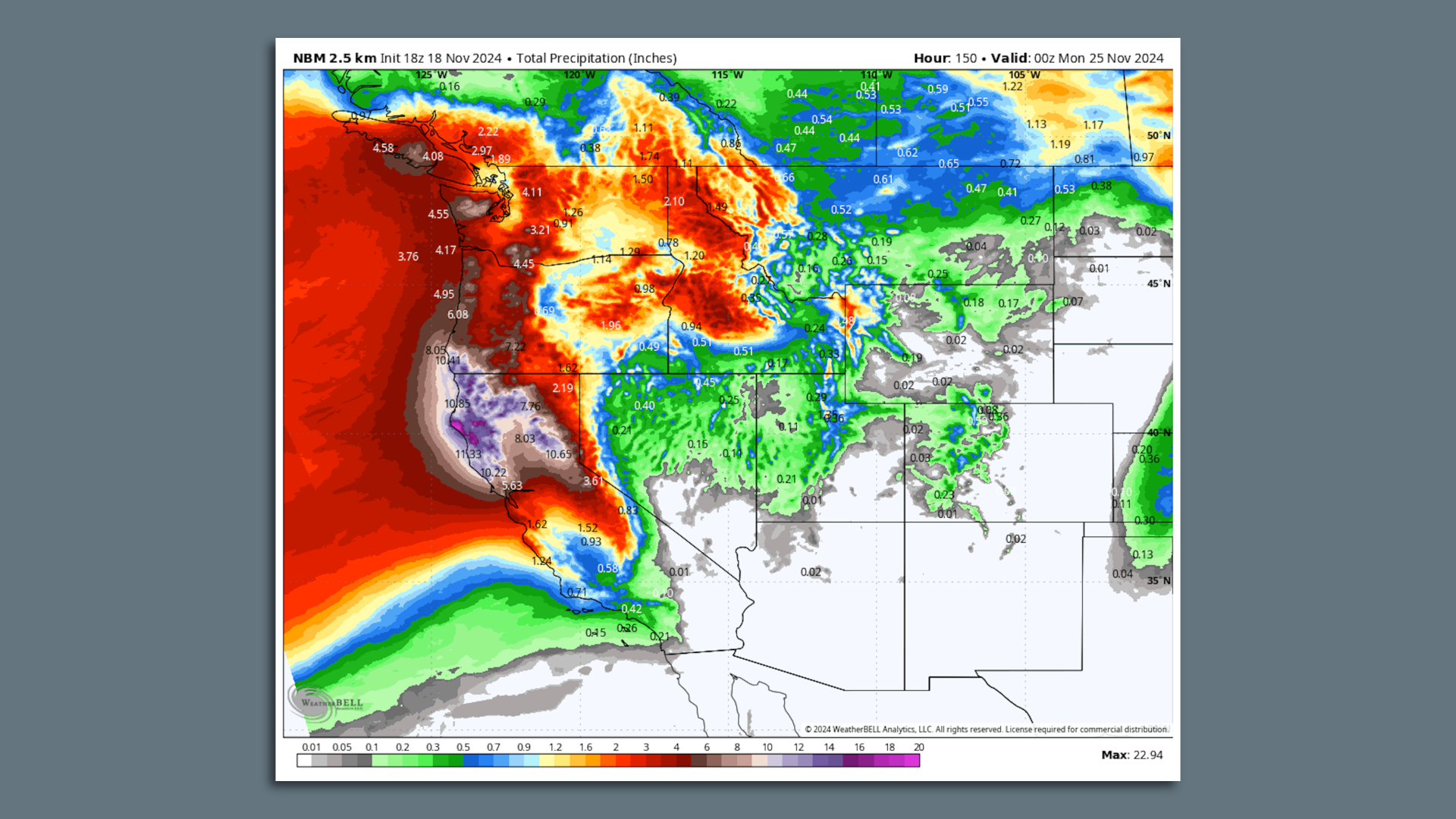
Map of computer model projections for rainfall totals across the West Coast through Sunday, Nov. 25. Image: Weatherbell.com
The West Coast is preparing for a long-duration heavy rain event from a bomb cyclone set to form Tuesday.
Threat level: The rapidly intensifying storm, taking shape in the northeastern Pacific Ocean, is forecast to direct a strong atmospheric river at southwestern Oregon and Northern California for days on end.
- The National Weather Service has issued a slew of watches and warnings ahead of the storm.
- The forecast office in Eureka, Calif. noted that an atmospheric river producing very heavy rainfall is likely to "park itself" over northwestern California starting Tuesday night and continue potentially into the weekend.
- That's raising flooding concerns for urban areas as well as rivers and streams over time — and the flooding could be significant.
The latest computer model projections show rainfall amounts that could reach 15 to 20 inches, or even higher, along coastal areas. The highest totals will be in elevated areas.
- In addition, power outages are possible as winds gusting to 70 mph or higher at times roar onto the coastline as the low-pressure system explosively intensifies offshore.
Zoom in: Even stronger winds, of up to 100 mph, are likely off the coast of Vancouver Island and west of Washington State, as the bomb cyclone reaches its peak intensity by Wednesday, before drifting off the coast while weakening into the weekend.
- Offshore wave heights could hit 70 feet, and high surf will pound the coastline of the Pacific Northwest.
- The low pressure area will qualify as a bomb cyclone due to its rapid rate of intensification.
- In fact, it may greatly exceed the meteorological definition of the phenomenon known as "bombogenesis," when a low pressure area intensifies by at least 24 millibars in 24 hours.
- This storm may intensify by as much as 50 millibars or more in that same timespan. As a general rule, stronger storms have lower minimum central air pressures associated with them.
At its peak intensity, the storm could qualify as one of the strongest low-pressure areas yet recorded in that region.
The big picture: To the south of the bomb cyclone's center, an atmospheric rivers will carry copious amounts of moisture from the subtropics, into Northern California and parts of Oregon.
- As their name suggests, atmospheric rivers are corridors of concentrated water vapor located in the middle atmosphere, about 10,000 to 20,000 feet above the surface.
- This particular atmospheric river event is forecast to rate as a 4 out of 5 on the Scripps Institution of Oceanography's severity scale, which takes into account the potential for heavy rainfall.
Context: Human-caused climate change is causing atmospheric rivers to carry more moisture and be capable of producing more rain and snow.
- One 2022 study found that atmospheric rivers that hit California in 2017 were up to 15% wetter due to human-caused climate change.
- Other recent studies show future atmospheric river events may heighten this trend.
- Warmer air and ocean temperatures add more water vapor to the atmosphere, which storms can ingest and wring out over land.
In California, atmospheric rivers have been responsible for some of the biggest flooding events on record, though this storm's heavy rain and mountain snow aren't expected to lead to a historic event.
The bottom line: Climate change is increasing the severity of heavy precipitation events, including atmospheric rivers, such as this one.

No comments:
Post a Comment