Tornado Outbreak Continues In The South Through Late Week As Pattern Change Takes Hold
Supercell thunderstorms could produce multiple long-lived EF3 or stronger tornadoes today in the mid-Mississippi and lower Ohio valleys.


By Chris Dolce, Jonathan Belles, and Jonathan Erdman
less than an hour ago

Millions Across Midwest, South Face Dangerous Weather Conditions
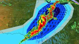
A tornado outbreak is expected through tonight in parts of the Midwest and South, prompting a rare "high" risk severe weather outlook to be issued.
High-risk severe forecasts (level 5 out of 5) are only issued two to three times a year by NOAA's Storm Prediction Center for particularly volatile setups like today. In this case, it was issued for the possibility of multiple long-lived EF3 or stronger tornadoes in the mid-South, mid-Mississippi and lower Ohio valleys.
NOAA's Storm Prediction Center states "a tornado outbreak is expected this afternoon into early tonight from parts of the lower Mississippi Valley into the Mid-South and lower Ohio Valley."
(LIVE UPDATES: The Latest On Damage Reports And More)
What We Are Tracking Now
A line of strong to severe storms is pressing eastward through the mid-Mississippi Valley and Ohio Valley. This line is expected to slow down overnight as it bumps into a dome of record heat located in the Southeast. Days of heavy rain and severe weather are likely in the mid-South and parts of the South and East as the pattern change locks into place.
NOAA's Storm Prediction Center has issued a "Particularly Dangerous Situation" tornado watch until 12 a.m. CDT for eastern Arkansas, southern Illinois, southern Indiana, western Kentucky, southeastern Missouri, northern Mississippi and western Tennessee. Strong tornadoes, destructive wind gusts and very large hail are possible. This watch area includes Memphis and Evansville, Indiana.
The SPC has also issued the following severe weather watches:
- A tornado watch until 10 p.m. CDT for eastern Illinois and western Indiana.
- A tornado watch valid until 12 a.m. CDT for southern Arkansas, northern Louisiana and northeast Texas.
A radar-confirmed tornado produced roof and tree damage earlier this morning just north of Tulsa, Oklahoma, near Owasso. Radar has also confirmed a tornado caused roof and tree damage near Nevada, Missouri. Tornadoes struck near Paxton, Illinois and Almyra, Arkansas, Wednesday evening. A strong tornado struck near Lake City, Monette and Leachville, Arkansas, mid-Wednesday evening.
Below is a look at the latest radar, watches and warnings.

Wednesday-Wednesday Night Forecast
-Widespread Threat: Severe weather packing tornadoes, destructive straight-line winds and hail the size of golf balls or larger could strike anywhere from northern Texas to the Great Lakes today and tonight. That includes Chicago, Cincinnati, Indianapolis, St. Louis, Little Rock, Louisville, Memphis, Nashville and Dallas-Fort Worth.

-Greatest Tornado Concern: As mentioned earlier, the threat of long-lived tornadoes that could produce EF3 or stronger damage is from the mid-South to portions of the mid-Mississippi and Ohio valleys from late afternoon into the evening. That includes the Memphis, Tennessee; Little Rock, Arkansas; and the Paducah and Louisville, Kentucky, areas.
-How It Will Evolve: Ongoing severe storms will continue to push eastward as new ones will develop later today and tonight, including dangerous supercell thunderstorms, from the ArkLaTex to the mid-Mississippi and Ohio valleys. In some cases, the severe weather threat will be in the evening or overnight, so be sure to have multiple ways to receive warnings, especially in eastern areas of the severe weather forecast shown below.

Thursday-Sunday
The cold front will stall out and produce a serious flood threat as well as additional bouts of scattered severe storms in the Midwest and South and East to end the week.
Here's a general overview of the severe weather forecast through the weekend:
-Thursday: The greatest potential for severe storms is from northeast Texas to western Tennessee, including Memphis and Little Rock. Several tornadoes and very large hail is possible in this area in red on the map below.
Scattered severe storms are also possible from northern Texas to the Tennessee valley and mid-Atlantic. Wind damage and large hail are the primary threats, but a few tornadoes are possible.
-Friday: Areas from central and eastern Texas to the Ohio Valley could see more severe storms that produce wind damage, large hail and a few tornadoes.


-This Weekend: The greatest potential for severe weather will be in the South on Saturday, especially the lower Mississippi Valley. Scattered severe storms are also possible as far north as the Ohio Valley. Damaging winds, large hail and tornadoes are all potential threats, but details are still coming into focus, so check back for updates.
On Sunday, there could be a lingering threat of severe storms in parts of Georgia, Alabama and northern Florida.

Chris Dolce has been a senior digital meteorologist with weather.com for nearly 15 years after beginning his career with The Weather Channel in the early 2000s.
No comments:
Post a Comment