An aquifer is an underground layer of water-bearing permeable rock, rock fractures or unconsolidated...
Aquifer
From Wikipedia, the free encyclopedia
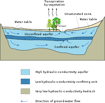
Typical aquifer cross-section
An
aquifer is an underground layer of
water-bearing
permeable rock, rock fractures or unconsolidated materials (
gravel,
sand, or
silt) from which
groundwater can be extracted using a
water well. The study of water flow in aquifers and the characterization of aquifers is called
hydrogeology. Related terms include
aquitard, which is a bed of low permeability along an aquifer,
[1] and
aquiclude (or
aquifuge),
which is a solid, impermeable area underlying or overlying an aquifer.
If the impermeable area overlies the aquifer, pressure could cause it to
become a confined aquifer.
Depth
Aquifers
may occur at various depths. Those closer to the surface are not only
more likely to be used for water supply and irrigation, but are also
more likely to be topped up by the local rainfall. Many desert areas
have limestone hills or mountains within them or close to them that can
be exploited as
groundwater resources. Part of the
Atlas Mountains in
North Africa, the
Lebanon and
Anti-Lebanon ranges between
Syria and
Lebanon, the
Jebel Akhdar (Oman) in
Oman, parts of the
Sierra Nevada and neighboring ranges in the
United States' Southwest, have shallow aquifers that are exploited for their water.
Overexploitation
can lead to the exceeding of the practical sustained yield; i.e., more
water is taken out than can be replenished. Along the coastlines of
certain countries, such as
Libya and Israel, increased water usage associated with population growth has caused a lowering of the water table and the
subsequent contamination of the
groundwater with saltwater from the
sea.
The
beach provides a model to help visualize an aquifer. If a hole is dug into the
sand, very wet or saturated sand will be located at a shallow depth. This hole is a crude
well, the wet sand represents an aquifer, and the level to which the water rises in this hole represents the
water table.
In 2013 large freshwater aquifers were discovered under continental
shelves off Australia, China, North America and South Africa. They
contain an estimated half a million cubic kilometers of “low salinity”
water that could be economically processed into potable water. The
reserves formed when ocean levels were lower and rainwater made its way
into the ground in land areas that were not submerged until the
ice age ended 20,000 years ago. The volume is estimated to be 100x the amount of water extracted from other aquifers since 1900.
[2][3]
Classification
The above diagram indicates typical flow directions in a
cross-sectional
view of a simple confined or unconfined aquifer system. The system
shows two aquifers with one aquitard (a confining or impermeable layer)
between them, surrounded by the bedrock
aquiclude, which is in contact with a gaining
stream (typical in
humid regions). The water table and
unsaturated zone are also illustrated. An
aquitard
is a zone within the earth that restricts the flow of groundwater from
one aquifer to another. An aquitard can sometimes, if completely
impermeable, be called an
aquiclude or
aquifuge. Aquitards are composed of layers of either
clay or non-porous
rock with low
hydraulic conductivity.
Saturated versus unsaturated
Groundwater
can be found at nearly every point in the Earth's shallow subsurface to
some degree, although aquifers do not necessarily contain
fresh water. The Earth's crust can be divided into two regions: the
saturated zone or
phreatic zone (e.g., aquifers, aquitards, etc.), where all available spaces are filled with water, and the
unsaturated zone (also called the
vadose zone), where there are still pockets of air that contain some water, but can be filled with more water.
Saturated means the pressure head of the water is greater than
atmospheric pressure (it has a gauge pressure > 0). The definition of the water table is the surface where the
pressure head is equal to atmospheric pressure (where gauge pressure = 0).
Unsaturated conditions occur above the water table where the
pressure head is negative (absolute pressure can never be negative, but
gauge pressure can) and the water that incompletely fills the pores of
the aquifer material is under
suction. The
water content in the unsaturated zone is held in place by surface
adhesive forces and it rises above the water table (the zero-
gauge-pressure isobar) by
capillary action to saturate a small zone above the phreatic surface (the
capillary fringe)
at less than atmospheric pressure. This is termed tension saturation
and is not the same as saturation on a water-content basis. Water
content in a capillary fringe decreases with increasing distance from
the phreatic surface. The capillary head depends on soil pore size. In
sandy soils with larger pores, the head will be less than in
clay
soils with very small pores. The normal capillary rise in a clayey soil
is less than 1.80 m (six feet) but can range between 0.3 and 10 m (one
and 30 ft).
[4]
The capillary rise of water in a small-
diameter
tube involves the same physical process. The water table is the level
to which water will rise in a large-diameter pipe (e.g., a well) that
goes down into the aquifer and is open to the atmosphere.
Aquifers versus aquitards
Aquifers are typically saturated regions of the subsurface that produce an economically feasible quantity of water to a well or
spring (e.g., sand and
gravel or fractured
bedrock often make good aquifer materials).
An aquitard is a zone within the earth that restricts the flow of
groundwater from one aquifer to another. A completely impermeable aquitard is called an
aquiclude or
aquifuge. Aquitards comprise layers of either clay or non-porous rock with low
hydraulic conductivity.
In mountainous areas (or near rivers in mountainous areas), the main aquifers are typically unconsolidated
alluvium,
composed of mostly horizontal layers of materials deposited by water
processes (rivers and streams), which in cross-section (looking at a
two-dimensional slice of the aquifer) appear to be layers of alternating
coarse and fine materials. Coarse materials, because of the high energy
needed to move them, tend to be found nearer the source (mountain
fronts or rivers), whereas the fine-grained material will make it
farther from the source (to the flatter parts of the basin or overbank
areas - sometimes called the pressure area). Since there are less
fine-grained deposits near the source, this is a place where aquifers
are often unconfined (sometimes called the forebay area), or in
hydraulic communication with the land surface.
Confined versus unconfined
There are two end members in the spectrum of types of aquifers;
confined and
unconfined (with semi-confined being in between).
Unconfined aquifers are sometimes also called
water table or
phreatic aquifers, because their upper boundary is the
water table or phreatic surface. (See
Biscayne Aquifer.)
Typically (but not always) the shallowest aquifer at a given location
is unconfined, meaning it does not have a confining layer (an aquitard
or aquiclude) between it and the surface. The term "perched" refers to
ground water accumulating above a low-permeability unit or strata, such
as a clay layer. This term is generally used to refer to a small local
area of ground water that occurs at an elevation higher than a
regionally extensive aquifer. The difference between perched and
unconfined aquifers is their size (perched is smaller). Confined
aquifers are aquifers that are overlain by a confining layer, often made
up of clay. The confining layer might offer some protection from
surface contamination.
If the distinction between confined and unconfined is not clear
geologically (i.e., if it is not known if a clear confining layer
exists, or if the geology is more complex, e.g., a fractured bedrock
aquifer), the value of storativity returned from an
aquifer test
can be used to determine it (although aquifer tests in unconfined
aquifers should be interpreted differently than confined ones). Confined
aquifers have very low
storativity values (much less than 0.01, and as little as 10
−5),
which means that the aquifer is storing water using the mechanisms of
aquifer matrix expansion and the compressibility of water, which
typically are both quite small quantities. Unconfined aquifers have
storativities (typically then called
specific yield)
greater than 0.01 (1% of bulk volume); they release water from storage
by the mechanism of actually draining the pores of the aquifer,
releasing relatively large amounts of water (up to the drainable
porosity of the aquifer material, or the minimum volumetric
water content).
Isotropic versus anisotropic
In
isotropic aquifers or aquifer layers the hydraulic conductivity (K) is equal for flow in all directions, while in
anisotropic conditions it differs, notably in horizontal (Kh) and vertical (Kv) sense.
Semi-confined aquifers with one or more aquitards work as an
anisotropic system, even when the separate layers are isotropic, because
the compound Kh and Kv values are different (see
hydraulic transmissivity and
hydraulic resistance).
When calculating
flow to drains [5] or
flow to wells [6] in an aquifer, the anisotropy is to be taken into account lest the resulting design of the drainage system may be faulty.
Groundwater in rock formations
Groundwater may exist in
underground rivers (e.g.,
caves where water flows freely underground). This may occur in
eroded limestone areas known as
karst topography,
which make up only a small percentage of Earth's area. More usual is
that the pore spaces of rocks in the subsurface are simply saturated
with water — like a kitchen sponge — which can be
pumped out for agricultural, industrial, or municipal uses.
If a rock unit of low
porosity is highly fractured, it can also make a good aquifer (via
fissure flow), provided the rock has a hydraulic conductivity sufficient to facilitate movement of water. Porosity is important, but,
alone, it does not determine a rock's ability to act as an aquifer. Areas of the
Deccan Traps (a
basaltic lava) in west central
India
are good examples of rock formations with high porosity but low
permeability, which makes them poor aquifers. Similarly, the
micro-porous (Upper
Cretaceous)
Chalk
of south east England, although having a reasonably high porosity, has a
low grain-to-grain permeability, with its good water-yielding
characteristics mostly due to micro-fracturing and fissuring.
Human dependence on groundwater
Most land areas on
Earth
have some form of aquifer underlying them, sometimes at significant
depths. In some cases, these aquifers are rapidly being depleted by the
human population.
Fresh-water aquifers, especially those with limited recharge by snow or rain, also known as
meteoric water, can be over-exploited and depending on the local
hydrogeology,
may draw in non-potable water or saltwater intrusion from hydraulically
connected aquifers or surface water bodies. This can be a serious
problem, especially in coastal areas and other areas where aquifer
pumping is excessive. In some areas, the ground water can become
contaminated by arsenic and other mineral poisons.
Aquifers are critically important in human habitation and
agriculture. Deep aquifers in arid areas have long been water sources
for irrigation (see Ogallala below). Many villages and even large cities
draw their water supply from wells in aquifers.
Municipal, irrigation, and industrial water supplies are provided
through large wells. Multiple wells for one water supply source are
termed "wellfields", which may withdraw water from confined or
unconfined aquifers. Using ground water from deep, confined aquifers
provides more protection from surface water contamination. Some wells,
termed "collector wells," are specifically designed to induce
infiltration of surface (usually river) water.
Aquifers that provide sustainable fresh groundwater to urban areas
and for agricultural irrigation are typically close to the ground
surface (within a couple of hundred metres) and have some recharge by
fresh water. This recharge is typically from rivers or meteoric water
(precipitation) that percolates into the aquifer through overlying
unsaturated materials.
Occasionally, sedimentary or
"fossil" aquifers are used to provide irrigation and drinking water to urban areas. In Libya, for example,
Muammar Gaddafi's Great Manmade River project has pumped large amounts of groundwater from aquifers beneath the Sahara to populous areas near the coast.
[7] Though this has saved Libya money over the alternative, desalination, the aquifers are likely to run dry in 60 to 100 years.
[7] Aquifer depletion has been cited as one of the causes of the food price rises of 2011.
[8]
Subsidence
In
unconsolidated aquifers, groundwater is produced from pore spaces
between particles of gravel, sand, and silt. If the aquifer is confined
by low-permeability layers, the reduced water pressure in the sand and
gravel causes slow drainage of water from the adjoining confining
layers. If these confining layers are composed of compressible silt or
clay, the loss of water to the aquifer reduces the water pressure in the
confining layer, causing it to compress from the weight of overlying
geologic materials. In severe cases, this compression can be observed on
the ground surface as
subsidence.
Unfortunately, much of the subsidence from groundwater extraction is
permanent (elastic rebound is small). Thus, the subsidence is not only
permanent, but the compressed aquifer has a permanently reduced capacity
to hold water.
Saltwater intrusion
Aquifers near the coast have a lens of freshwater near the surface
and denser seawater under freshwater. Seawater penetrates the aquifer
diffusing in from the ocean and is denser than freshwater. For porous
(i.e., sandy) aquifers near the coast, the thickness of freshwater atop
saltwater is about 40 feet (12 m) for every 1 ft (0.30 m) of freshwater
head above sea level. This relationship is called the Ghyben-Herzberg
equation. If too much ground water is pumped near the coast, salt-water
may intrude into freshwater aquifers causing contamination of potable
freshwater supplies. Many coastal aquifers, such as the Biscayne Aquifer
near Miami and the New Jersey Coastal Plain aquifer, have problems with
saltwater intrusion as a result of overpumping and sea level rise.
Salination
Aquifers in surface
irrigated areas in semi-arid zones with reuse of the unavoidable irrigation water losses
percolating down into the underground by supplemental irrigation from wells run the risk of
salination.
[9]
Surface irrigation water normally contains salts in the order of
0.5 g/l or more and the annual irrigation requirement is in the order of
10000 m³/ha or more so the annual import of salt is in the order of
5000 kg/ha or more.
[10]
Under the influence of continuous evaporation, the salt concentration
of the aquifer water may increase continually and eventually cause an
environmental problem.
For
salinity control in such a case, annually an amount of drainage water is to be discharged from the aquifer by means of a subsurface
drainage system and disposed of through a safe outlet. The drainage system may be
horizontal (i.e. using pipes,
tile drains or ditches) or
vertical (
drainage by wells). To estimate the drainage requirement, the use of a
groundwater model with an agro-hydro-salinity component may be instrumental, e.g.
SahysMod.
Examples
The
Great Artesian Basin situated in Australia is arguably the largest groundwater aquifer in the world
[11] (over 1.7 million km²). It plays a large part in water supplies for Queensland and remote parts of South Australia.
The
Guarani Aquifer, located beneath the surface of
Argentina,
Brazil,
Paraguay, and
Uruguay, is one of the world's largest aquifer systems and is an important source of
fresh water.
[12] Named after the
Guarani people,
it covers 1,200,000 km², with a volume of about 40,000 km³, a thickness
of between 50 m and 800 m and a maximum depth of about 1,800 m.
Aquifer depletion is a problem in some areas, and is especially critical in northern
Africa; see the
Great Manmade River project of
Libya
for an example. However, new methods of groundwater management such as
artificial recharge and injection of surface waters during seasonal wet
periods has extended the life of many freshwater aquifers, especially in
the United States.
The
Ogallala Aquifer of the central United States is one of the world's great aquifers, but in places it is being rapidly
depleted
by growing municipal use, and continuing agricultural use. This huge
aquifer, which underlies portions of eight states, contains primarily
fossil water from the time of the last
glaciation.
Annual recharge, in the more arid parts of the aquifer, is estimated to
total only about 10 percent of annual withdrawals. According to a 2013
report by research hydrologist Leonard F. Konikow
[13] at the
United States Geological Survey
(USGC), the depletion between 2001–2008, inclusive, is about 32 percent
of the cumulative depletion during the entire 20th century (Konikow
2013:22)."
[13] In the United States, the biggest users of water from aquifers include agricultural irrigation and oil and coal extraction.
[14]
"Cumulative total groundwater depletion in the United States
accelerated in the late 1940s and continued at an almost steady linear
rate through the end of the century. In addition to widely recognized
environmental consequences, groundwater depletion also adversely impacts
the long-term sustainability of groundwater supplies to help meet the
Nation’s water needs."
[13]
An example of a significant and sustainable carbonate aquifer is the
Edwards Aquifer[15] in central
Texas.
This carbonate aquifer has historically been providing high quality
water for nearly 2 million people, and even today, is full because of
tremendous recharge from a number of area streams, rivers and
lakes. The primary risk to this resource is human development over the recharge areas.
Discontinuous sand bodies at the base of the
McMurray Formation in the
Athabasca Oil Sands region of northeastern
Alberta,
Canada, are commonly referred to as the
Basal Water Sand (BWS) aquifers.
[16] Saturated with water, they are confined beneath impermeable
bitumen-saturated sands that are exploited to recover bitumen for
synthetic crude oil production. Where they are deep-lying and recharge occurs from underlying
Devonian formations they are saline, and where they are shallow and recharged by
meteoric water they are non-saline. The BWS typically pose problems for the recovery of bitumen, whether by
open-pit mining or by
in situ methods such as
steam-assisted gravity drainage (SAGD), and in some areas they are targets for waste-water injection.
[17][18][19]
See also
References


80° | Check Traffic
 WASHINGTON >> The U.S. announced the first fatality in a wreck involving a car in self-driving mode, the 40-year-old owner of a technology company who nicknamed his vehicle “Tessy” and had praised its sophisticated “Autopilot” system just one month earlier for preventing a collision on an interstate. The government said it is investigating the design and performance of the system aboard the Tesla Model S sedan.

 An aquifer is an underground layer of water-bearing permeable rock, rock fractures or unconsolidated materials (gravel, sand, or silt) from which groundwater can be extracted using a water well. The study of water flow in aquifers and the characterization of aquifers is called hydrogeology. Related terms include aquitard, which is a bed of low permeability along an aquifer,[1] and aquiclude (or aquifuge), which is a solid, impermeable area underlying or overlying an aquifer. If the impermeable area overlies the aquifer, pressure could cause it to become a confined aquifer.Typical aquifer cross-section
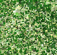 Most land areas on Earth have some form of aquifer underlying them, sometimes at significant depths. In some cases, these aquifers are rapidly being depleted by the human population.Center-pivot irrigated fields in Kansas covering hundreds of square miles watered by the Ogallala Aquifer
 Aquifers in surface irrigated areas in semi-arid zones with reuse of the unavoidable irrigation water losses percolating down into the underground by supplemental irrigation from wells run the risk of salination.[9]Diagram of a water balance of the aquifer


