
HURRICANE CENTRAL
begin quote from:
Hurricane Laura Strengthens Into a Category 4; Catastrophic Strike Ahead Near Louisiana and Texas Border
By weather.com meteorologists
2 hours ago
weather.com
01:15
Hurricane Laura Strengthens Into a Category 4
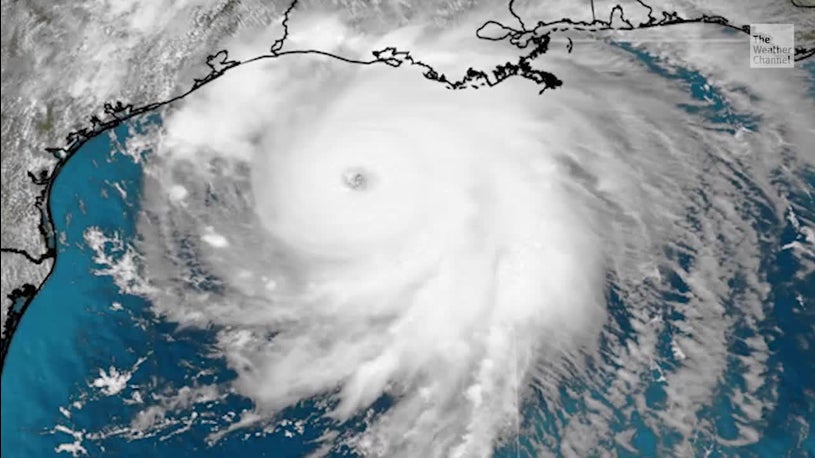
Hurricane Laura has strengthened into a Category 4 as it heads for a destructive landfall near the Texas and Louisiana border Wednesday night into early Thursday morning.
At a Glance
- Laura has rapidly intensified into a Category 4 as it approaches landfall.
- Laura will make landfall Wednesday night into early Thursday near the border between Louisiana and Texas.
- Catastrophic storm surge and damaging winds will affect areas near where Laura makes landfall.
- Storm surge could penetrate as much as 30 miles inland in southwest Louisiana.
- Laura is also an inland flood risk as far north and east as Arkansas and the Ohio and Tennessee valleys.
- Isolated tornadoes are also expected from Laura.
Hurricane Laura has strengthened into a Category 4 as it heads for a destructive landfall near the Texas and Louisiana border Wednesday night into early Thursday morning. A catastrophic storm surge and damaging winds will batter the region and a threat of flooding rain and strong winds will extend well inland.
Residents along the upper Texas and southwest Louisiana coasts should finish preparations now for a major hurricane strike. Follow any evacuation orders issued by local or state officials.
(LATEST NEWS: Hundreds of Thousands Ordered to Evacuate)
Current Status
Laura is centered about 175 miles south of Lake Charles, Louisiana. It's tracking to the northwest at 16 mph.
The hurricane is now a Category 4 with 140 mph winds. Some slight additional strengthening is possible through this afternoon.
NOAA's Storm Prediction Center has issued a tornado watch until 9 p.m. CDT for parts of Louisiana and southeastern Texas. The watch area includes Baton Rouge, Alexandria, Lake Charles and Lufkin.
Laura's maximum sustained winds jumped from 75 mph to 140 mph in the 24 hours ending 1 p.m. CDT Wednesday. That increase in maximum sustained winds easily meets the definition of rapid intensification in a hurricane.
Doppler radar shows that bands of rain and gusty winds are now beginning to pivot into the northwest Gulf Coast.
A wind gust to 107 mph was reported at a buoy near the center of Laura early Wednesday morning. A water level station at Eugene Island, Louisiana reported about 3.2 feet of inundation above ground level early Wednesday afternoon and a wind gust of 45 mph.
Laura has prompted hurricane and storm surge warnings for the northwest Gulf Coast.
A storm surge warning is in effect from Freeport, Texas, to the mouth of the Mississippi River in southeast Louisiana, including Galveston Bay and areas inside the Port Arthur, Texas, hurricane flood protection system.
This means a life-threatening storm surge is expected in the next 36 hours. Residents in these areas should heed all evacuation orders and instructions from local emergency management and take necessary precautions to protect life and property.
A hurricane warning is now in effect from San Luis Pass, Texas, to Intracoastal City, Louisiana. This includes Galveston, parts of the east Houston metro area, Beaumont and Port Arthur, Texas, Lake Charles, Louisiana, and several additional inland counties and parishes of east Texas and western Louisiana extending north of Interstate 10. Hurricane conditions (winds 74 mph or greater) will affect these areas Wednesday night and Thursday.
Tropical storm warnings extend into the rest of the Houston metro area, parts of northeast Texas, northern Louisiana and southern Arkansas.

Current Watches and Warnings
(A watch is issued when tropical storm or hurricane conditions are possible within 48 hours. A warning is issued when those conditions are expected within 36 hours.)Forecast
Track and Intensity
The National Hurricane Center (NHC) forecast shows Laura will curl more to the north on Wednesday and Thursday.
Laura is predicted to be a Category 4 hurricane when it approaches landfall near the Texas and Louisiana border Wednesday night into early Thursday morning. Conditions are expected to deteriorate in these areas later Wednesday.
Current Information
(The red-shaded area denotes the potential path of the center of the tropical cyclone. It's important to note that impacts (particularly heavy rain, high surf, coastal flooding, winds) with any tropical cyclone usually spread beyond its forecast path.)
It appears much of the Houston metro area will avoid a worst-case scenario since Laura is expected to track east of the city. However, parts of the metro area will still rain and strong winds from Laura.
The bottom line is that Laura will bring catastrophic storm surge, flooding rainfall and damaging wind impacts to parts of Texas and Louisiana Gulf Coasts beginning later Wednesday. The worst conditions will be Wednesday night and Thursday.
Keep in mind that a hurricane isn't just a point. Impacts will extend far from where the center eventually moves inland.
(MORE: Why the Projected Path For Hurricanes and Tropical Storms Doesn't Always Tell the Full Story)
Storm Surge Threat
The highest storm surge is expected along and to the immediate east of the center of Laura as it moves ashore Wednesday night into early Thursday. Areas from the far upper Texas coast into southwest Louisiana will have an "unsurvivable storm surge," the National Hurricane Center (NHC) said.
The NHC predicts an inundation of 15 to 20 feet above ground level from Johnson Bayou, Louisiana, to Rockefeller Wildlife Refuge, Louisiana, including Calcasieu Lake, if it occurs at high tide. Storm surge could be 10 to 15 feet above ground level in areas near the border between Louisana and Texas, including Sabine Lake. A storm surge of 10 to 15 feet above ground level is also possible from Intracoastal City, Louisiana, to Rockefeller Wildlife Refuge, Louisiana.
The National Hurricane Center said storm surge could penetrate up to 30 miles inland from the coast in southwest Louisiana and far southeast Texas.
A river gauge on the Calcasieu River at Saltwater Barrier located near Lake Charles, Louisiana, is forecast to surpass its record level by more than two feet because of the storm surge early Thursday morning. Over half the city of Lake Charles is flooded when this river hits record flood stage at that location, according to a list of impacts from the National Weather Service.
See the map below for other storm surge peak inundation forecasts from the NHC.
Follow the advice of local and state officials if you are ordered to evacuate an area prone to storm surge flooding.
Storm Surge Forecast
(From the NHC, this forecast shows potential peak inundation in feet of normally dry ground if the storm surge occurs at high tide. )
Wind
Tropical storm conditions are expected in the hurricane warning area by late Wednesday, with hurricane conditions expected Wednesday night and Thursday.

Wind Gust Forecast
Catastrophic wind damage is possible on the upper Texas and southwest Louisiana coasts. This includes widespread power outages possibly lasting for days, if not over a week, downed trees and structural damage. Wind gusts are likely to top 100 mph in these areas.
The potential for tree damage and power outages will affect areas farther inland along the path of Laura across eastern Texas, Louisiana, Arkansas and western Tennessee.
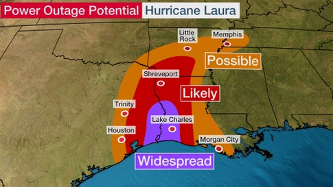
Power Outage Potential
Heavy Rain Threat
Laura will also spread rain and wind impacts far inland through parts of the lower Mississippi Valley and Ohio Valley into Saturday.
According to NOAA's Weather Prediction Center and the National Hurricane Center, parts of western Louisiana, eastern Texas and much of Arkansas could pick up 5 to 10 inches, with isolated amounts up to 15 inches.
A high risk of excessive rainfall has been issued by NOAA into early Thursday for parts of southeastern Texas and southwestern Louisiana, including Beaumont, Port Arthur and Lake Charles. Rainfall rates of 5 to 7 inches per hour are possible, meaning dangerous flash flooding is expected. However, storm surge flooding will occur in this same area.
Locally heavy rain is also possible from the lower and mid-Mississippi valleys into the Ohio and Tennessee valleys late Friday into Saturday. These areas could see as much as 2 to 4 inches of rainfall.
This could lead to widespread flash flooding, especially in urban areas, and minor to moderate river flooding that could linger for some time after Laura leaves.

Forecast Rainfall Through Friday
(This should be interpreted as a broad outlook of where the heaviest rain may fall and may shift based on the forecast path of the tropical cyclone. Higher amounts may occur where bands of rain stall over a period of a few hours. Some of this rain may be associated with Marco or its remnant.)
Tornadoes
Landfalling hurricanes sometimes produce tornadoes to the east of where the storm's center tracks.
The area with the greatest chance of seeing a few tornadoes from Laura on Wednesday afternoon and Wednesday night is from southeastern Texas into southwest Mississippi.

Tornado Potential Wednesday Night
(Shaded on the map above is the likelihood of severe thunderstorms (tornado potential in this case), according to NOAA's Storm Prediction Center. Note that not all categories apply for the severe weather risk on a particular day.)
Portions of Louisiana, western Mississippi and Arkansas could see a few tornadoes on Thursday.

Tornado Potential Thursday-Thursday Night
(Shaded on the map above is the likelihood of severe thunderstorms (tornado potential in this case), according to NOAA's Storm Prediction Center. Note that not all categories apply for the severe weather risk on a particular day.)Laura's History
Tropical Depression Thirteen formed in the Atlantic last Wednesday night (Aug. 19) and strengthened into Tropical Storm Laura on Friday morning (Aug. 20.)
Laura is the earliest Atlantic 'L' named storm on record. The previous record was Luis on Aug. 29, 1995, according to Phil Klotzbach, tropical scientist at Colorado State University.

Laura's Track History
Laura brought heavy rainfall and gusty winds to the Leeward Islands and Puerto Rico later Friday through Saturday.
Southern parts of Puerto Rico picked up 2 to 6 inches of rainfall.
Winds gusted up to 75 mph at Salinas, along Puerto Rico's southern coast.
Portions of the Dominican Republic picked up nearly a foot of rain from Laura over the weekend, which triggered serious flash flooding in some areas.
Sustained winds of 60 mph with a gust over 70 mph was measured in Guantanamo Bay, Cuba, Sunday evening.
Laura made landfall on the Pinar del Rio province in western Cuba around 8:00 p.m. Monday with maximum sustained winds of about 65 mph.
A wind gust of 69 mph was measured in Key West, Florida, Monday afternoon as a line of showers associated with Laura moved through.
Laura became the fourth hurricane of the 2020 Atlantic hurricane season Tuesday morning, based on measurements taken by NOAA hurricane hunter aircraft.
The Weather Company’s primary journalistic mission is to report on breaking weather news, the environment and the importance of science to our lives. This story does not necessarily represent the position of our parent company, IBM.
No comments:
Post a Comment