begin quote from:
https://www.cnn.com/2021/12/26/weather/weather-holiday-travel-west-snow-cold-sunday/index.html
Snow and cold will make for difficult post-Christmas travel across the western and northern United States
By Allison Chinchar and Haley Brink, CNN Meteorologists
Updated 10:24 AM ET, Sun December 26, 2021


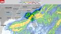
Record heat in the South as West sees heavy rain and snow 02:04
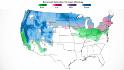
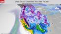
(CNN)Snow and cold continue to blanket the western and northern United States, setting up hazardous post-Christmas travel conditions Sunday and into the final week of 2021.
Across the Intermountain West, "travel will remain dangerous and is discouraged, especially along mountain passes where long duration closures are likely. Dangerous avalanches are also likely in the Sierra Nevada, Washington Cascades, Northern Rockies, and Wasatch," the Weather Prediction Center said Saturday.
Bitter cold in the coming days will also impact states from Montana to Michigan.
"Dangerously cold air continues through the next few days, bringing wind chills to below -40° to some areas, especially along the Hi-Line," the National Weather Service office in Great Falls, Montana, said Sunday in a tweet. "Temperatures this cold can cause frostbite in under 10 minutes! Don't forget your pets and livestock. Stay weather aware."
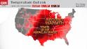
Meantime, unseasonable warmth will continue to toast the South as wildfire risk stretches across the central Plains.
Avalanche warnings in 6 Western states
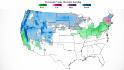
All this snow may be a ski-lover's dream, but it also covers roads and reduces visibility. Avalanche warnings are in effect Sunday for portions of Nevada, Utah, Idaho, Montana, Colorado and California as recent heavy snowfall and wind have made for widespread areas of unstable snow.

Enter your email to sign up for CNN's "Meanwhile in China" Newsletter.
close dialog
"Avalanches may run long distances and can run into lower angle terrain typically thought of as safe," the Eastern Sierra Avalanche Center warned Sunday.
Large snow and rain systems have moved through Western states in the past few weeks, resulting in impressively high snowpack for California. The Golden State by Saturday had recorded 130% of its normal snowpack for that date; it had been at only 18% on December 1.
And more moisture is on the way for much of the West over the next several days. New snowfall will be measured in feet across the Sierras, Cascades and Rocky Mountains. A band of heavier snow has setup in the Seattle metro area Sunday, with snow accumulations of 4 to 6 inches expected, with locally higher total possible.

Heavy rainfall is expected in lower elevations, possibly leading to localized flash flooding in places where the ground is saturated. Las Vegas, for example, has picked up 2 inches of rain since Wednesday -- four times its December average. Rain is due to return there Monday, potentially mixing in with some snow on Tuesday.
More rain also is forecast for parts of the West Coast that saw heavy rain the past 24 hours. That includes areas of Santa Barbara County, California, and other northwestern Los Angeles suburbs, which just picked up over an inch of rain. A weather gauge near the University of Southern California campus reported nearly a 10th of an inch in just 2 minutes overnight Saturday, according to the NWS office in Los Angeles.
Frigid conditions for the Midwest
Snow will also fall Sunday across the Upper Midwest, with accumulations of over a foot possible from the Dakotas through northern Michigan. Winter storm alerts have been issued for eastern North Dakota, northern Minnesota and northwest Wisconsin.
"Accumulating snow, along with potential drifting will make some roads nearly impossible to traverse," the weather service office in Grand Forks, North Dakota, said Sunday. "As we head into Monday, blowing snow becomes more of an impact, with reduced visibility likely."
As this system sweeps over the Great Lakes, lake-effect snow enhancements are certain as most of the lakes remain ice-free. Heavy lake-effect snow coupled with winds gusting to 40 mph will lead to near-blizzard conditions. Blizzard warnings could be issued, according to weather service in Duluth, Minnesota.
"Temperatures outside in the Northern Plains will be frightful this week," the prediction center said Sunday in a tweet. "A large area will drop below 0F with some areas falling to -30F. Wind will make it feel even colder. Very limited exposure -- if any -- outside would be ideal."

Even after this system moves through, the cold temperatures don't let up.
Morning lows are forecast to be sub-zero across portions of Montana and North Dakota, with daytime highs Sunday struggling to get out of the single digits. By Monday morning, lows are forecast to be bitterly cold, potentially as cold as below 15 to below 25, and wind chills will be even colder.
Fargo, North Dakota, goes from a high of 25 degrees on Monday to a high of only 1 degree on Tuesday. Denver sees a similar drop, from 48 degrees Monday to 34 degrees Tuesday.
Warmth continues further south, as does fire threat
Remarkably warm temperatures remain anchored over the southern US today and will continue into the first half of the week. Over 250 total daily record warm lows and highs are expected to be broken in the next few days.
Temperature departures today will be warmest in the southern Plains, with highs in the 70s and 80s -- 25 to 40 degrees above normal.
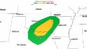
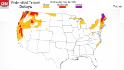
A "critical risk" of fire weather -- level 2 out of 3 -- is in effect across the Texas and Oklahoma Panhandles and in eastern Colorado and western Kansas owing to the unusually warm temperatures, low humidity levels and windy conditions.

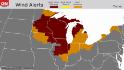
Sustained winds of 30 to 50 mph with gusts of 60 to 80 mph could lead to blowing dust and difficult travel conditions across these regions Sunday. High wind warnings and red flag warnings are in place.
No comments:
Post a Comment