veronica.rocha@latimes.com
hailey.branson@latimes.com
brittny.mejia@latimes.com
Times staff writer Mejia reported from Tehachapi, Rocha and Branson-Potts from Los Angeles.
end partial quote from:
California mudslides and chaos offer a preview of what El Niño could bring
I think it is important this year (not since 1995 and 1997and 8 has the potential for flooding and mudslides been this bad.
So, maybe studying the areas that were vulnerable during the Arc STorm of 1862 might be important. Because that was the states worst flooding encounter in history. Because it turned California from a primarily Cattle STate to a Farming state because 1/4 of the cattle in California in 1862 were washed likely eventually into the ocean or left to rot after having died from that epic flood.
-
Great Flood of 1862 was the largest flood in the recorded history of Oregon, Nevada, and California, occurring from December 1861 to January 1862. It was39 KB (3,953 words) - 15:42, 13 October 2015
Great Flood of 1862
From Wikipedia, the free encyclopedia The Great Flood of 1862 was the largest flood in the recorded history of Oregon, Nevada, and California, occurring from December 1861 to January 1862. It was preceded by weeks of continuous rains (or snows in the very high elevations) that began in Oregon in November 1861 and continued into January 1862. This was followed by a record amount of rain from January 9–12, and contributed to a flood which extended from the Columbia River southward in western Oregon, and through California to San Diego, and extended as far inland as Idaho in the Washington Territory, Nevada and Utah in the Utah Territory, and Arizona in the western New Mexico Territory.
The event was climaxed by a warmer, more intense storm with much more rain that was much more serious, due to the earlier large accumulation of snow, now melted by the large turbulent heat fluxes into the snow over the lower elevations of the mountains. Throughout the affected area, all the streams and rivers rose to great heights, flooded the valleys, inundated or swept away towns, mills, dams, flumes, houses, fences, and domestic animals, and ruined fields. An early estimate of property damage was $10 million.[1] However, later it was estimated that approximately one-quarter of the taxable real estate in the state of California was destroyed in the flood. Dependent on property taxes, the State of California went bankrupt. The governor, state legislature, and state employees were not paid for a year and a half.[2] Approximately 200,000 cattle drowned, and the state's economy shifted from ranching to farming.[3]
In recent years, the flood has held the attention of the United States Geological Survey and emergency planners, who used it as an example when modelling the impact of a similar event happening in modern-day California. The official name for such an event is "The Arkstorm", and it is unofficially called "The other big one".[4][5]
Contents
Background
 The floods were likely caused by precipitation from atmospheric rivers, or narrow bands of water vapor about a mile above sea level that extend for thousands of kilometers.[6]A map of the flood area of the hypothetical ARkStorm event
Prior to the flooding, Oregon had steady but heavier than normal rainfall during November and heavier snow in the mountains.[7]
The weather pattern that caused this flood was not from an El Nino, and from the existing Army and private weather records, it has been determined that the polar jet stream was to the north as the Pacific Northwest experienced a mild rainy pattern for the first half of December 1861. The jet stream then slid south and freezing conditions were reported at Oregon stations by December 25. Heavy rainfall began falling in California as the longwave trough moved down over the state, remaining there until the end of January 1862 and causing precipitation everywhere in the state for nearly 40 days. Eventually the trough moved even further south, causing snow to fall in the Central Valley and surrounding mountain ranges.[8]
Oregon
There was an excess of precipitation in November 1861 over most of Oregon, less so in the extreme northwest. It was cold enough at the higher elevations that much snow fell in the Cascade Range, which when later melted by the warm rains produced a great quantity of water that flooded into the Willamette River and other streams in the Cascades. Tributaries of the Willamette rising in the Oregon Coast Range did not rise so high. Then the depression that came in at the beginning of December produced strong, warm southerly winds in Oregon, with extremely heavy rain. The crest of the flood was reached at Salem on December 3; at Oregon City on the 4th; at Milwaukie, between Oregon City and Portland, on the 5th; at Albany on December 8, a second rise at Albany greater than the first. The crest at Albany and Salem were the highest ever known at any time. In Oregon, the flood was one of the largest in the history of the Willamette Valley and the rest of Western Oregon. Flooding was heaviest on rivers with tributaries arising from the snow-covered Cascade Range.[7]
An article in the December 14, 1861, Oregon City Argus, described the course of the flood at Oregon City:
Flood waters were so high that at Oregon City at the flood's crest on December 5, the steamer St. Clair was able to run the falls, and steamers were able to visit points at some distance from the normal river channel. Although large amounts of wheat and flour were swept away, some was recovered when Oregon City's Island Mill was found on Sauvie Island downriver from Portland. The nearby town of Linn City was completely destroyed by flooding and was not rebuilt.[9] In addition, the flood destroyed the historic town of Champoeg, site of the first provisional government in Oregon, and Orleans, across the Willamette River from Corvallis. Neither was rebuilt.[7]“ During the month of November the rain had been falling almost continuously, and a vast amount of snow must have accumulated in the mountains. No snow, however, had fallen in the Willamette Valley, and the river, up to Sunday, December 1st, exhibited no indication of an unusual rise. It might have been noticed, and doubtless will be again if the phenomenon ever occurs hereafter, that November's long and rather cold rain was succeeded during the closing days of the month by a warm, humid state of the air, rain falling in copious showers almost without intermission. On Sunday the river looked swollen and threatening, but, until still later, no serious apprehensions were entertained. On Monday morning the steamer Rival left this place for Portland while the Express came up on her usual trip, but finding navigation difficult and dangerous they concluded to leave the trip half done, each boat stopping at the wrong end of her route. The Onward also started up the river on her usual trip. The Island Mill was kept running Monday and through the night. Mr. John Chapman and his wife being on the Island unsuspicious of danger. But the crash of the falling bridge just before daylight, destroying all egress to the main land, roused them to a consciousness of immediate danger, and they passed several anxious hours before help could be extended to them and they could be extricated from their perilous situation in skiffs from below. This was accomplished safely and in good time, for the water was rising rapidly, and by afternoon rushed down the chasm over which the bridge had stood in a way to prevent all approach. This afternoon (Tuesday) a large part of the breakwater at the warehouse on the opposite side of the river succumbed to the immense pressure of water, and at intervals great masses of timbers comprising the crib-work would burst up and be swept away by the mighty torrent. Tuesday evening a gloom settled on a scene such as probably never was witnessed in our Valley before. The ceaseless roar of the stream made a fearful elemental music widely different from the ordinary monotone of the Falls; while the darkness was only made more visible by the glare of torches and hurrying lights, which with the shouts of people from the windows of houses surrounded by the water, all conspired to render the hour one of intense and painful excitement. The flood has covered the highest mark of January '53, and is still rapidly rising. As late as anything could be seen the mills were still standing, but the insatiate monster is still creeping up inch by inch, winding its swelling folds round the pillars and foundations of all the houses in its way, crushing and grinding them in the maw of destruction, and sweeping the broken fragments into a common vortex of ruin. All night as on the night previous, people whose homes were being invaded hurried to places of security, glad to escape even with the sacrifice of all their goods.
The light of Wednesday morning revealed a scene of desolation terrible in its extent no less than in its completeness. The Oregon City and Island Mills, Willamette Iron Works, Foundry and Machine Shop; all the breakwaters designed to protect the mills and upper end of Oregon City except one short piece are carried away, and over where they stood now sweeps a foaming current against which no building unprotected by a solid breakwater as a defense could possibly stand. An immense amount of drift has passed and apparently the debris of many houses but everything is ground so fine and is hurried out of sight so quickly that little can be known for certain. On the fragments of a large barn, as appeared by the quantity of grain, straw, etc., sat a number of chickens, bearing melancholy evidence of devastation above. We were compelled to vacate our office this afternoon, the water rising nearly two feet on the floor. Main Street is navigable for skiffs past our door down as far as the Masonic Hall.[7]
”
The flooding was also severe in other parts of Oregon; the Umpqua River had the greatest flood known even to the oldest Native Americans, and water was 10 to 15 feet (3.0 to 4.6 m) higher than the 1853 flood. It rose from November 3 to December 3, subsided for two days, then rose again until the 9th. At Fort Umpqua, communication upriver was cut off above Scottsburg, and the river was full of floating houses, barns, rails and produce. At Port Orford, the Coquille River swept away settlers' property and also did great damage on the Rogue River and on other small streams."[7]
Flood damage was so great because the rivers in Oregon were the main routes of travel. The river front was the building site of mills, freight depots, and storehouses for grain and other foodstuffs. Business houses and many residences were near the landings. Farm buildings were mostly on sites convenient to the rivers, along with supplies of feed for livestock. Loss of so much wheat flour and demand from the new Idaho gold fields caused a spike in its price from $7 to $12 per barrel.
Idaho
In the interior of Washington Territory, the storm creating the flood in Oregon dumped its precipitation as an unprecedented snowfall. Flooding on the Columbia River and the snow in the mountains closed off supplies to the new mining towns on the Salmon River, causing starvation among the miners of Florence, cut off from December until May 1862. In early July, as the heavy burden of snow in the mountains melted, the runoff caused great flooding. The Boise River flooded from extremely high runoff and is believed to been four times larger than its largest recorded flood in 1943. Flood waters made the river expand to a couple of miles wide.[10] It washed away or covered the original route of the Oregon Trail in the river valley.[11]
Northern California
Fort Ter-Waw, located in Klamath, California, was destroyed by the flood in December 1861 and abandoned on June 10, 1862.[12] Bridges were washed away in Trinity and Shasta counties.[13] At Weaverville, John Carr was a witness to the sudden melt of snow by the heavy rain and onset of the flood in December 1861 on the Trinity River:
Two years later William H. Brewer saw near Crescent City, the debris of the flood:“ The winter of 1861–2 was a hard one. From November until the latter part of March there was a succession of storms and floods. I remember my being in Weaverville, I think it was in the month of December, 1861. ... It had been raining all the day previous. The ground was covered with snow 1 foot (0.30 m) deep, and on the mountains much deeper. We arrived at the ranch just before dark, and I wanted to cross his bridge and stay at John Carter's that night, but " Uncle " Strudivant would not listen to any such thing. Stay with him I must. He told me that the bridge was named Jeff Davis, and that old Trinity could not carry enough water to wash "Jeff" out,.... He had a private cottage a short distance from the ranch and toll-house. It was close to the foot of the mountain, the divide between Weaverville and the Trinity River. ... He and I advocated our respective sides of the political issues until 11 o'clock, when we " turned in." It rained all afternoon and night. The weather had turned warm, and the rain came down in torrents. Several times I went to the door during our political discussion, and every time it seemed to be raining harder, and I wished myself on the other side of Trinity River. I frequently said, " Uncle Joe, I am afraid the bridge will go." His reply was, " Jeff will stand it." ... We slept until about 4 o'clock in the morning, when Jerry Whitmore, one of Uncle Joe's partners, came to where we were, and knocked on the door to wake us up. Uncle Joe called out, " What is wanted?" Jerry replied, "The bridge is gone—not a stick left, and, the water will soon be up to the house." The water in the river had been rising all night, and men were stationed on the bridge with poles to keep logs from striking the piers. At about 4 o'clock in the morning a large spruce tree came down the river with roots, branches and all. The men seeing it come, and knowing the bridge was doomed, escaped from the bridge before the roots of the tree struck it. It was well they did, for one of the men who were on the bridge told me next morning that as soon as the tree struck the bridge it went through it as if nothing had been in its way, cutting it completely in two, and the whole structure fell into the river and was soon out of sight. As soon as daylight came Uncle Joe and I went to the ruins. Not a plank of the bridge was left. The rain was yet pouring down. The snow was nearly all gone. Everything around the place looked desolate. On the flat where the house was built they had the finest bearing orchard in Northern California. If the river rose but a little more, the trees would be swept away, and the house with them. All the forenoon the river continued to rise, and at last it began to spread over the orchard and wash the black loam away. Finally, as the current became stronger amongst the trees, one after another began to fall, some floating off with the water, and others hanging by the roots. Trinity that morning was playing havoc with the settlers on its banks. It was dreadful to look upon. Standing on high ground, one could see property of all kinds on its way to the ocean. The river itself seemed like some mighty uncontrollable monster of destruction broken away from its bonds, rushing uncontrollably on, and everywhere carrying ruin and destruction in its course. When rising, the river seemed highest in the middle. When falling, it became lowest in the middle, and all the drift worked toward the center of the stream. When the river was at or near its highest, one could see floating down parts of mills, sluice-boxes, miners cabins, water-wheels, hen-coops, parts of bridges, bales of hay, household furniture, sawed lumber, old logs, huge spruce and pine trees that had withstood former storms for hundreds of years—all rushing down that mad stream on their way to the boundless ocean. From the head settlement to the mouth of the Trinity River, for a distance of one hundred and fifty miles, everything was swept to destruction. Not a bridge was left, or a mining-wheel or a sluce-box. Parts of ranches and miners cabins met the same fate. The labor of hundreds of men, and their savings of years, invested in bridges, mines and ranches, were all swept away. In forty-eight hours the valley of the Trinity was left desolate. The county never recovered from that disastrous flood. Many of the mining-wheels and bridges were never rebuilt..[14]
”
“ The floods of two years ago brought down an immense amount of driftwood from all the rivers along the coast, and it was cast up along this part of the coast in quantities that stagger belief. It looked to me as if I saw enough in ten miles along the shore to make a million cords of wood. It is thrown up in great piles, often half a mile long, and the size of some of these logs is tremendous. I had the curiosity to measure over twenty. They were worn by the water and their bark gone, but it is not uncommon to see logs 150 feet long and 4 feet in diameter at the little end where the top is broken off. One I measured was 210 feet long and 3 1/2 feet at the little end, without the bark.[15]:495 ” Flooding of the Central Valley
- "The rainy season commenced on the 8th of November, and for four weeks, with scarcely any intermission, the rain continued to fall very gently in San Francisco, but in heavy showers in the interior. According to the statement of a Grass Valley paper, nine inches of rain fell there in thirty-six hours on the 7th and 8th inst. Whether, it is possible that so much rain could fall in thirty-six hours I will not decide; but it is certain that, the amount was great, for the next day the river-beds were full almost to the hilltops. The North Fork of the American River at Auburn rose thirty-five feet, and in many other mountain streams the rise was almost as great. On the 9th the flood reached the low land of the Sacramento Valley."[7]
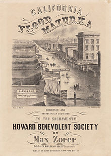 The entire Sacramento and San Joaquin valleys were inundated for an extent of 300 miles (480 km), averaging 20 miles (32 km) in breadth.[17] John Carr wrote of his riverboat trip up the Sacramento River when it was at one of its highest stages of flood:Sheet music cover depicting Sacramento flooding
The city of Sacramento suffered the worst damage due to its levee, which lay in a wide and flat valley at the junction of the American and Sacramento rivers. When the floodwaters entered from the higher ground on the east, the levee acted as a dam to keep the water in the city rather than let it flow out. Soon the water level was 10 feet (3.0 m) higher inside than the level of the Sacramento River on the outside. Dozens of wood houses, some two stories high, were simply lifted up and carried off by the flood, as was "all the firewood, most of the fences and sheds, all the poultry, cats, rats and many of the cows and horses". A chain gang was sent to break open the levee, which, when it finally broke, allowed the waters to rush out of the city center and lowered the level of the flooding by 5–6 feet (1.5–1.8 m). Eventually the waters fell to a level on a par with the lowest part of the city.[7] From 1861 to 1862, the state capital was moved from flooded Sacramento to San Francisco.“ ... I was a passenger on the old steamer "Gem", from Sacramento to Red Bluff. The only way the pilot could tell where the channel of the river was, was by the cottonwood trees on each side of the river. The boat had to stop several times and take men out of the tops of trees and off the roofs of houses. In our trip up the river we met property of every description floating down—dead horses and cattle, sheep, hogs, houses, haystacks, household furniture, and everything imaginable was on its way for the ocean. Arriving at Red Bluff, there was water everywhere as far as the eye could reach, and what few bridges there had been in the country were all swept away. I managed to get to Cottonwood, and had to lay over for a week before any of the streams between there and Hay Fork Valley were fordable.[7] ”
Nevada
The Carson River Basin of the eastern California and western Utah Territory (now Nevada), suffered from a similar pattern of flooding. Flooding began in December 1861 in Carson Valley from a series of storms in the upper Carson River basin. Two feet (61 cm) of wet heavy snow fell on December 20, 1861, accumulating on the valley floor. Snow was followed by a period of very cold temperatures which froze the snow, followed by a three-day rain starting on December 25, 1861. By January 2, 1862, the town of Dayton and the area surrounding it had been flooded.[18]
In the vicinity of Aurora, there had been light snowfall in November, then mild weather until Christmas Eve, when there began a heavy and rapid snowfall for days. The temperature dropped below zero and the passes over the Sierras were closed. During the second week of January, it warmed slightly, and the snow became a torrential rain. Esmerelda and Willow gulches overflowed their banks and flooded Aurora. With water standing up to 3 inches (76 mm) deep in many buildings, adobe buildings turned to mud and collapsed. After a week, it cooled again, and snow began to fall again. Within a few days, the snow was deeper than it had been before the rains had begun to fall. Samuel Young of Aurora recorded in his diary that the snow and rain had fallen for 26 days out of 30 since December 24, 1861.[19]
Utah
The early southwestern Utah settlements in Washington County: Fort Clara, St. George, Grafton, Duncans Retreat, Adventure, and Northrop were nearly destroyed by a flood on the Virgin and Santa Clara Rivers, that followed 44 days of rainfall in January and February 1862.[20] Survivors of Fort Clara established the modern town of Santa Clara a mile east of the old fort on the Santa Clara River.[21] Springdale and Rockville were founded in 1862 by settlers flooded out of Adventure, Northup and other places in the vicinity.[20]
Settlers were driven from Fort Harmony when the fort had to be abandoned after most of its adobe walls were washed away during this flood. New Harmony and Kanarraville, in Iron County, were the settlements created by refugees from this disaster later in 1862.[22]:174
Southern California
In Southern California, beginning on December 24, 1861, it rained for 28 days in Los Angeles.[15]:243 In the San Gabriel Mountains the mining town of Eldoradoville was washed away by flood waters.[23] The flooding drowned thousands of cattle and washed away fruit trees and vineyards that grew along the Los Angeles River. No mail was received at Los Angeles for five weeks. The Los Angeles Star reported that:
The road from Tejon, we hear, has been almost washed away. The San Fernando mountain cannot be crossed except by the old trail ... over the top of the mountain. The plain has been cut up into gulches and arroyos, and streams are rushing down every declivity.[24]
The plains of Los Angeles County, at the time a marshy area with many small lakes and several meandering streams from the mountains, were extensively flooded, and much of the agricultural development that lay along the rivers was ruined. In most of the lower areas, small settlements were submerged. These flooded areas formed into a large lake system with many small streams. A few more powerful currents cut channels across the plain and carried the runoff to the sea.
In Los Angeles County, (including what is now Orange County) the flooding Santa Ana River created an inland sea lasting about three weeks with water standing 4 feet (1.2 m) deep up to 4 miles (6 km) from the river.[17] In February 1862, the Los Angeles, San Gabriel, and Santa Ana Rivers merged. Government surveys at the time indicated that a solid expanse of water covered the area from Signal Hill to Huntington Beach, a distance of approximately 18 miles (29 km).[25] :38
At Santa Barbara County, the narrow coastal plains were flooded by the rivers coming out of the mountains. The San Buenaventura Mission Aqueduct that was still drawing water from a tributary of the Ventura River for the town of Ventura water system, was abandoned due to the damage in the area that become the separate Ventura County in 1873.[26]
In San Bernardino County, all the fertile riverside fields and all but the church and one house of the New Mexican colony of Agua Mansa, were swept away by the Santa Ana River, which overflowed its banks. Father Borgotta ringing the church bell on the night of January 22, 1862, alerted the inhabitants to the approach of the flood, and all escaped.[27]
In San Diego, a storm at sea backed up the flood water running into the bay from the San Diego River, resulting in a new river channel cut into San Diego Harbor. The continuous heavy downpour also changed the look of the land, the previously rounded hills were extensively cut by gulleys and canyons.[25]
To the north, in the Owens Valley, similar snow and flooding conditions as those to the east in Aurora, lead to the local Paiute suffering the loss of much of the game they depended on. Cattle newly driven into the valley to feed the miners, competed with the native grazers and ate the native wild plant crops the Paiute depended on to survive. Starving, the Paiute began to kill the cattle and conflict with the cattlemen began, leading to the subsequent Owens Valley Indian War.
Arizona
In western New Mexico Territory, heavy rains fell in late January, causing severe flooding of the Colorado River and Gila River. On January 20, 1862, the Colorado River began to rise, and on the afternoon of January 22 it rose suddenly in three hours from an already high stage nearly 6 feet (1.8 m), overflowing its banks and turned Fort Yuma in California into an island in the midst of the Colorado River. At 1 o’clock on the morning of January 23, the river reached its crest.[28] Jaeger City a mile down river from Fort Yuma, and Colorado City, across the Colorado River from it were washed away. The river overflowed its banks to the extent that there was water 20 feet (6.1 m) deep on a ranch in the low lying ground just above Arizona City where the Gila River joined the Colorado. The riverside home of steamboat entrepreneur George Alonzo Johnson and the nearby Hooper residence were the only places in the town unharmed because they were built on high ground.[29] Colorado City had to be rebuilt on higher ground after the 1862 flood.[30]
The Gila River also flooded, covering its whole valley at its mouth where it met the Colorado from the sand hills on the south to the foothills on the north. Twenty miles (32 km) to the east of Fort Yuma, it swept away most of the mining boomtown of Gila City along with a supply of hay being gathered there to supply the planned advance of the California Column into Confederate Arizona. Further east the road was flooded, buildings and vehicles swept away and traffic was disrupted for some time thereafter by the mud covering the road to Tucson.[31] The great flood in the Gila and Colorado rivers, covered their bottom lands with mud. Much of the livestock along the rivers drowned and the crops of the Indians along the river were destroyed.[32]
The overflow of the 1862 Colorado River flood waters reached the Salton Sink via the Alamo and New Rivers, filling it and creating a lake some 60 miles (97 km) long and 30 miles (48 km) wide.[33]
Sonora, Mexico
Until the Great Flood of 1862, what became Port Isabel Slough, in Sonora, Mexico, was a shallow tidewater slough, but the extreme flood waters of that year cut its channel much deeper, so that at low tide it still was three fathoms deep. The mouth of this slough was only 5 miles (8.0 km) from the mouth of the river and sheltered from the extremes of the tidal bore of the Colorado River and deep enough to prevent stranding on shoals or mud flats at low tide.[34] This made it an ideal anchorage for maritime craft to load and unload their cargo and passengers from the steamboats that took them up and down river with out the danger from the tides that they were having to risk in the estuary at Robinson's Landing.
In the month of March 1865, the schooner Isabel, from San Francisco, commanded by W. H. Pearson, found and entered this slough and discharged her cargo there for the first time. Subsequently, the steamers, sailing ships and later ocean-going steamships loaded and off-loaded their cargoes there, and the steamboat company established Port Isabel 2.5 miles (4.0 km) above the mouth of the slough.[35]
References
- "The Great Flood in California: Great Destruction of Property Damage $10,000,000". The New York Times. 21 January 1862.


Cite error: Invalid
Cite error: Invalid
Cite error: Invalid
Cite error: Invalid
Cite error: Invalid
External links
Categories:
- Floods in the United States
- 1861 floods
- 1862 floods
- Natural disasters in California
- Natural disasters in Idaho
- Natural disasters in Nevada
- Natural disasters in Oregon
- Natural disasters in Utah
- Natural disasters in Arizona
- History of the West Coast of the United States
- History of Southern California
- History of Inyo County, California
- 1862 in California
- 1862 in New Mexico Territory
- 1862 in Utah Territory
- 1862 in Washington Territory
No comments:
Post a Comment