CAVE FIRE EVACUATIONS TO BE LIFTED WEDNESDAY


Photos: Mike Eliason / SBCFD
Update by edhat staff
8:00 a.m., November 27, 2019
Officials report the rain helped firefighting efforts and the evacuations should be lifted on Wednesday.
At 11:30 p.m. Tuesday officials removed evacuation warning for the area North of Foothill Road between Ontare and Gibraltar Road. Santa Barbara County Public Works the San Roque and San Antonio basins on Wednesday morning.
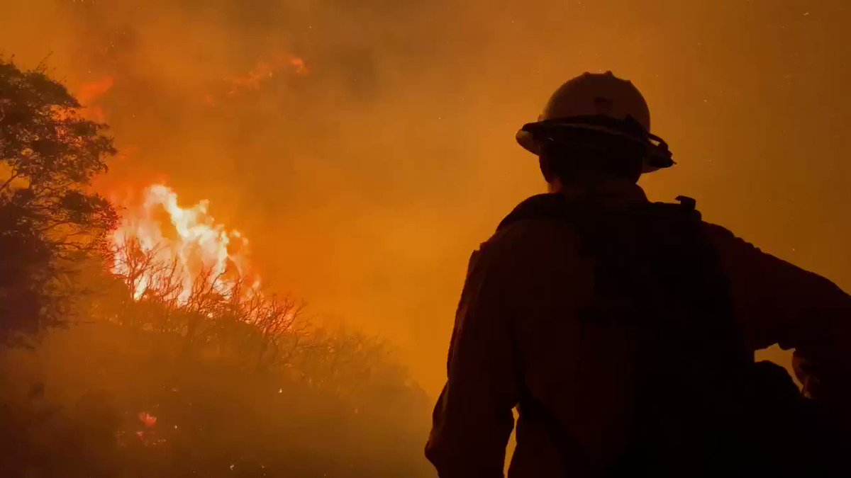
The Cave Fire areas received up to an inch of rain in the past 24 hours which significantly helped firefighters battle the blaze. Mike Eliason with the Santa Barbara County Fire Department reports 20% containment of the fire is expected to grow significantly today. The total acreage is 4,367.
Firefighters will remain on scene to extinguish "stubborn smoke" as resources begin demobilization today. Incident Command is reporting good progress on the fire fight with repopulation plans to be evaluated as all evacuees should be in their homes later today in time for Thanksgiving, reports Eliason.
Rain is still forecasted and the colder overnight storm could actually bring a slight chance of snow near the higher elevation of the fire, if you could believe that.

With small smokes still smoldering below, a rainbow appears above the burn scar near Painted Cave Road Wednesday morning (Photo: Mike Eliason)
Start Date: Nov. 25, 2019
Cause: Unknown
Size: 4,367 acres
Containment: 20%
Personnel: 600
Structures Threatened: 2,410 structures threatened, 0 residential structures burned
Injuries: 0
EVACUATIONS
Mandatory Evacuations
- Evacuation order boundaries expanded from Ontare Road to Patterson Ave. north of Cathedral Oaks, south of Camino Cielo.
Evacuation Warning
- West of Hwy 154 to El Sueno, below Cathedral Oaks to Calle Real.
- Patterson Avenue/Anderson Lane and Ontare Road, between the 3500 and 3300 block of State Street and down through Las Positas Road, and south of East Camino Cielo to the ocean.
ROAD CLOSURES
- Highway 154 from SR-246 to SR-192/Foothill Road
- Gibraltar Road
- La Vista Road at Foothill Road
- Debra Drive at Antone Road
- Via Chaparral at Cathedral Oaks
- San Marcos Road at Cathedral Oaks
POWER OUTAGES
Parts of southern Santa Barbara County are experiencing power outages due to impacts from the Cave Fire. This outage is not related to a Public Safety Power Shutoff (PSPS). Outages have been reported in unincorporated areas between the cities of Goleta and Santa Barbara, along Highway 154 through Mission Canyon, and parts of Summerland and Carpinteria.
The SCE Outage Map can be .
SHELTER
Goleta Valley Community Center
5679 Hollister Road. Goleta
5679 Hollister Road. Goleta
Animal Sheltering: For Assistance, call Hotline: 805-681-4332
Small Animals:
Goleta Animal Shelter, 5473 Overpass Rd.
Large Animals:
Earl Warren Showgrounds, 3400 Calle Real, Santa Barbara
Goleta Animal Shelter, 5473 Overpass Rd.
Large Animals:
Earl Warren Showgrounds, 3400 Calle Real, Santa Barbara
EMERGENCY CONTACT NUMBERS
- Emergency Call Center: (833) 688-5551
- 211 or outside (805) area code, call (800) 400-1572
- Animal Evacuation Assistance: (805) 681-4332
- Southern California Edison: 1-800-611-1911
Do NOT call 911 unless there is an emergency
Update by County of Santa Barbara
10:30 p.m., November 26, 2019
The Santa Barbara County Sheriff’s Office has issued a Debris Flow Evacuation Warning due to a strong storm arriving tonight, Tuesday, November 26, for the area between Patterson Avenue/Anderson Lane and Ontare Road, between the 3500 and 3300 block of State Street and down through Las Positas Road, and south of East Camino Cielo to the ocean.
Public safety officials have determined that there is a risk for potential debris flows in and below the Cave Fire burn area. National Weather Service has predicted rainfall Tuesday evening into Wednesday morning, with isolated thunderstorms that can increase rainfall intensity. Residents are advised to prepare an evacuation kit and a plan to leave.
If you feel uncomfortable or unsafe at any time, do not wait, leave the area and move outside the Fire Evacuation Order and Debris Flow Evacuation Warning area. If you live or are near creeks and streams, be aware that waterways may experience high flows and can rise quickly. Flooding impacts may be experienced throughout the county, but are a higher risk and may be observed below the Thomas, Sherpa, Alamo and Whittier burn areas.
If a debris flow occurs, and it is unsafe to leave, or you are unable to leave, go to high ground. Stay alert to changing conditions and follow the instructions of public safety officials. The Cave Fire Evacuation Order remains in place. To access the County’s interactive map, go to .
The public is encouraged to avoid going out in the storm and to stay off roads. As a precaution, do not walk through flood waters; six inches of moving water may knock you off your feet. If you are trapped by moving water, move to the highest possible point and call 911 for help.
Do not drive into flooded roadways or around barricades. Water may be deeper than it appears and may hide hazards, such as sharp objects, washed out road surfaces, electrical wires, chemicals, etc. Twelve inches of water can float a car or small SUV. For additional information, call the County’s Call Center at (833) 688-5551.

Update by edhat staff
4:00 p.m., November 26, 2019
Rain is anticipated Tuesday evening after midnight and will hopefully aid firefighting efforts. The approaching front will continue erratic gusty north winds in the fire area through tonight with peak gusts of winds up to 40 mph. Humidity is relatively low near 15% and expected to improve later tonight.
 Map of Cave Fire footprint (Photo: Mike Eliason)
Update by edhat staff
11:30 a.m., November 26, 2019
A section of mandatory evacuations has been reduced for the Cave Fire that's now reached 4,262 acres. It's at 0% containment and there are no reported injuries. One outbuilding has been destroyed but no residences have been affected.
Officials held a press conference at 11:00 a.m. Tuesday and stated the current firefighting conditions are the "toughest in the world" due to low humidity, several extreme wind events, and dry fuel. The fire crossed over Highway 154 in several places and the roadway remains closed.
However, the mandatory evacuations have been reduced from Fairview to Patterson Ave on the western boundary. The evacuation will be lifted by noon and residents are welcome to return home in this area, although some sections are without power as requested by firefighters.
The rest of the evacuations will stay put for some time, said Sheriff Bill Brown. Approximately 5,481 people evacuated on Tuesday with 324 people staying in their home.
Rain is expected to reach Santa Barbara on Tuesday evening and should help diminish the fire, although officials are concerned about it creating hazards for the firefighters and potentially small rockslides on Highway 154. Officials do not feel the amount of rain expected will cause a mudslide.

Evacuation map is not yet updated and has not removed Fairview to Patterson Ave ()
Update by edhat staff
8:00 a.m., November 26, 2019
The Cave Fire has reached 4,100 acres and is 0% contained as of Tuesday morning.
There are 600 firefighters on the scene and no reported injuries or structures damaged. The evacuation orders remain the same from Monday evening, according to Mike Eliason of the Santa Barbara County Fire Department.
At 10:30 p.m. on Monday, Santa Barbara County proclaimed a local emergency. Read the emergency proclamation .
A press conference will be held at 11:00 a.m. Tuesday to discuss ongoing firefighter efforts.

Update by edhat staff
9:30 p.m., November 25, 2019
An evacuation warning has been issued for the areas from Highway 154 to El Sueno and Cathedral Oaks to Calle Real, according to the Sheriff's Office. An additional Evacuation Warnings is being issued for the area North of Foothill Road and Ontare to Gibraltar Road.
Due to changing conditions of the fire, the Evacuation ORDER is now from Highway 154 to Fairview, and Highway 154 to Ontare, north of Cathedral Oaks Road. The evacuation map can be .
As of 9:30 p.m., the estimated acres burned is reportedly over 3,100 acres.
Roadways remained closed in the area.
Update by edhat staff
6:58 p.m., November 25, 2019
Mandatory evacuations have been extended to north of Cathedral Oaks between Highway 154 and Patterson Ave.
Santa Barbara County Sheriff's Office just announced the evacuation at 6:55 p.m. Monday.
The first mandatory evacuation order still stands, from Painted Cave to Camino Cielo and Highway 154 east to Ontare Road.
A second fire is burning near the Cave Fire has reportedly jumped the Windy Gap. Early reports indicate the fire began around 6:25 p.m. near 1960 N. San Marcos Road. It's being reported this second fire has reached Highway 154 and jumped the Windy Gap and is burning above the Bridge to Nowhere.
CHP is reporting a large group of cars and bystanders are blocking the roadway for emergency personnel and evacuees. If you do not need to be in the area, stay away.

Shelter Location:
Goleta Valley Community Center
5679 Hollister Road. Goleta
Goleta Valley Community Center
5679 Hollister Road. Goleta
Animal Sheltering: For Assistance, call Hotline: 805-681-4332
Small Animals:
Goleta Animal Shelter, 5473 Overpass Rd.
Large Animals:
Earl Warren Showgrounds, 3400 Calle Real, Santa Barbara
Goleta Animal Shelter, 5473 Overpass Rd.
Large Animals:
Earl Warren Showgrounds, 3400 Calle Real, Santa Barbara
Update by edhat staff
6:15 p.m., November 25, 2019
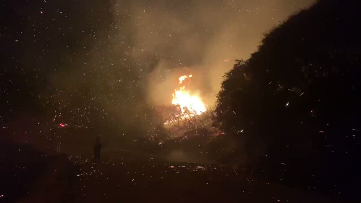
Mandatory evacuations have been issued for the Painted Cave community as a 15-acre brush fire, named the Cave Fire, grows.
Santa Barbara County Fire Department, Los Padres National Forest Fire Department, and Montecito Fire Department are on scene near Painted Cave and E. Camino Cielo. Crews are battling a wind-driven fire that sparked around 4:13 p.m. Monday.
Strong wind is in the forecast tonight and it's encouraged that residents are vigilant and aware of what is happening. Evacuation orders can quickly change.
California Highway Patrol have closed Highway 154 at SR-246 and Foothill Road as well as Cathedral Oaks at S San Marcos Rd.

116 people are talking about this
Update by Office of Emergency Management
5:42 p.m., November 25, 2019
5:42 p.m., November 25, 2019
Due to the fire in the Panted Cave area, an Evacuation order is issued for the area between Highway 154 and Ontare, and below East Camino Cielo and Foothill road. more information will follow as it becomes available.
Debido al incendio en el área de Painted Cave, se emitio una orden de evacuación para el área entre la Carretera 154 y Ontare, y debajo de la East Camino Cielo y Foothill Rd. Más información se proporcionará cuando esté disponible.
74 people are talking about this
Reported by Roger the Scanner Guy
4:24 p.m., November 25, 2019
Brush fire off Camino De Cielo at Painted Cave. SB County Fire Department sending a full response.
PHOTOS BY EDHAT READERS
Cave Fire view from Decker's Building in Goleta (Photo: Robert Bernstein)

2:43am from Painted Cave (Photos: Lynn)


Cathedral Oaks from Highway 154 (Photos: John Wiley)


Photos by Patti Gutshall


Photos by Christian Puga


Upper State Street by Beverly Cross


View from the Turnpike shopping center


No comments:
Post a Comment