Atmospheric river could bring a travel nightmare after Thanksgiving holiday
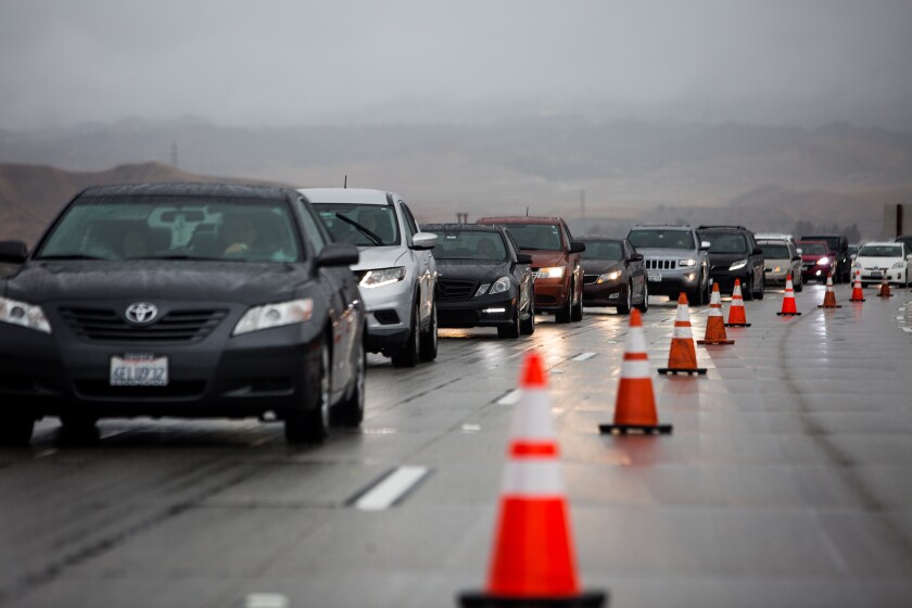
Traffic is backed up along the northbound 5 Freeway after the Grapevine was closed on Thanksgiving.
(Jason Armond / Los Angeles Times)
Much is made about traffic in the days before Thanksgiving.
But the traffic back home after the holiday weekend can also be nasty — and this year be particularly problematic because of the weather.
Just on the heels of California’s first statewide storm of the wet season, an even more powerful storm is expected to hit Northern and Central California on Saturday and persist through Tuesday. Southern California will miss the atmospheric river, but could see some rain starting Tuesday as the weather pattern changes.
The storm will likely tie up roads for skiers returning home to the San Francisco Bay Area from Lake Tahoe ski resorts and the Los Angeles area from Mammoth beginning Saturday night. Also, Interstate 5 between Redding and Mount Shasta city — which saw a 24-hour closure just before Thanksgiving — could see a foot of snow.
If people want to avoid getting stuck, they should head back as early as possible Saturday morning. The worst precipitation will begin Saturday night.
This storm is forecast to be longer lasting for Northern and Central California, posing a risk of mudslides. The moisture fueling the storm starting this weekend will be fed by an atmospheric river of subtropical moisture.
What is an atmospheric river?
An atmospheric is a long plume of water vapor that can pour over from the Pacific Ocean through California.
![This Car Puts the Joy Back in Driving [See More]](https://ntvcld-a.akamaihd.net/image/upload/w_600,h_338,c_fill,f_auto/assets/21C2A430AB4443F181AC63C902E3804A.gif)
This Car Puts the Joy Back in Driving [See More]
Discover the legacy that only gets better with time.
It carries so much water that it’s like a river in the sky. A strong atmospheric river can carry 7½ to 15 times the average flow of liquid water at the Mississippi River’s mouth.
Just a few atmospheric river events can bring West Coast states such as California from one-third to one-half of their annual precipitation.
How will this atmospheric river hit California?
Forecasters are tracking a new region of low pressure dropping south out of the Gulf of Alaska. By Friday night into Saturday morning, it’ll trek east into Northern California, and be fed by a plume of moisture coming all the way in the Pacific Ocean just north of Hawaii, according to Carolina Walbrun, meteorologist with the weather service’s Monterey office.
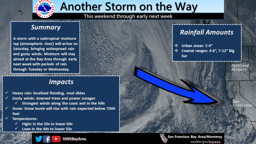
(National Weather Service)
How will this storm affect California?
San Francisco Bay Area and Central California: The storm is expected to bring rain across the Bay Area starting Saturday afternoon and persist through Tuesday before tapering off Wednesday; a fresh storm system is expected next Friday. Unlike the pre-Thanksgiving storm, which brought rain in a narrow band that moved fairly quickly through the region, this storm will have a lot more moisture, and bring rain almost everywhere, varying between light rain to periods of heavy rain for the weekend, Walbrun said.
“It’s feast or famine in California — if we have drought, we’ve got drought; if we have rain, we have rain,” Walbrun said.
The warmer storm carries a lot more moisture than the pre-Thanksgiving colder storm. The storm will likely spread as far south as Monterey County on Saturday and as far south as Santa Barbara County on Sunday.
Mountains of Northern California: Forecasters are warning of major travel delays, near white-out conditions and road closures generally starting Saturday afternoon. People trying to leave out of the Sierra Nevada could face problems through late Monday.
The snow could ease in the Interstate 5 area between Redding and Mount Shasta city by Sunday afternoon, but is expected to continue to be troublesome for Sierra Nevada roads through Monday.
Anyone traveling between Mount Shasta city and Redding on Interstate 5 should try to avoid the roadway between Saturday afternoon and Sunday morning. This part of the roadway reaches an elevation of 3,912 feet and could get a foot of snow; too many motorists without chains during a snowstorm brought this section of roadway closed for 24 hours before Thanksgiving.
Forecasters urged motorists to just avoid traveling during this time, but if they have to, “they gotta have chains, have blankets, food and water,” said Ryan Sandler, meteorologist with the Medford, Ore., weather service office.
Southern California: Southern California will miss out of this atmospheric river, but initial indications are rain could return by Tuesday afternoon as low pressure moves in from the Gulf of Alaska. Next week’s storm for Los Angeles, at this point, is forecast to not produce nearly as much rain as the pre-Thanksgiving and Thanksgiving storm, according to Tom Fisher, meteorologist with the weather service’s Oxnard office.
No comments:
Post a Comment