begin quote from:
Rain, Traffic and Flood Reports | Edhat
https://www.edhat.com/news/rain-traffic-and-flood-reports
1 day ago - Rain, Traffic and Flood Reports. Rain ... #CAstorm-Rain runoff flows and crosses East Valley Road Wednesday March 21 in Montecito near San Ysidro Creek. ... Now expecting total rain amounts through 2-4" coast/valleys 4-8" foothills/mtns for SLO/SB/western Ventura Counties, and 1-2" coast/valleys, 2-5" ...RAIN, TRAFFIC AND FLOOD REPORTS

Montecito residents Greg Giloth and Ellen Easton check the flow of Montecito Creek from East Valley Road Wednesday (Photo: Mike Eliason / SBCFD)
Below are the latest reports of storm traffic, flooding, and rain. Add your updates in the comments section and send any photos or graphics to to be posted.
Thursday, March 22, 2018
4:00 p.m., Santa Barbara County
The Santa Barbara County Sheriff’s Office, in consultation with Unified Command and other public safety officials, has announced that effective today (Thursday, March 22) at 5 p.m., Mandatory Evacuation Orders will be lifted for all areas. Read the full report .
3:30 p.m., Edhat reader Loren
San Antonio Creek at Tuckers Grove is handling the rain well. Picture taken at 3:30pm Thursday. There was a little blockage and backup upstream but flowing well.

3:28 p.m. City of Santa Barbara
1:37 p.m.,
As water flows, an excavator is used to clear boulders and debris out of San Ysidro Basin in Montecito Thursday March 22 following heavy rains. The scars from the deadly 1/9 debris flow are still visible surrounding the basin and creek.
1:11 p.m.,
Montecito creek at Hammonds Beach
11:13 a.m., City of Santa Barbara
12:06 p.m, COSB Public Works
ROAD CLOSURE: As of 10:15am, Refugio at Calle Real closed due to flooding of creek crossings.
10:47 a.m., Santa Barbara City Fire Department
Video taken in the last 30 minutes from El Capitan taken by Santa Barbara County Battalion Chief Rob Hazard.
10:42 a.m.,
Cold Spring Basin is doing its job above Montecito.
10:16 a.m.,
Rain band just West of El Capitan State Beach - dropping rain at 0.54 inches 15-min rate, impressive. Great campground (on a dry day!!)

9:46 a.m., Santa Barbara County
Update from incident personnel: Rain falling at .83 inches per hour near Refugio right now. System is moving east, towards Santa Barbara area.
9:28 a.m.,
Flash Flood Warning including Santa Barbara County, CA until 12:30 PM PDT

9:11 a.m.,
The yellow line south of Solvang is some heavier rain moving into the Sherpa and Whittier Fire burn areas at 0910.

7:21 a.m.,
Thursday morning briefing underway at Earl Warren Showgrounds in Santa Barbara for firefighters from multiple counties and California Army National Guard. The resources are assigned to the Santa Barbara South Coast Area during this rain event.

7:05 a.m., Santa Barbara County
2700 block of Tepesquet Road in the Santa Maria area is flooded with mudslides on the road. Please avoid this this area which is currently impassible. CHP in route.
5:55 a.m.,
The flow of Montecito Creek and others increased dramatically early Thursday morning following a brief but intense rain in the Santa Barbara and Montecito area. While it is not raining at the moment, more is on the way. For updates go to .
4:46 a.m., Santa Barbara County
NWS has issued a flash flood watch for all SBCounty through 5pm. Risk for debris flows in burn area and periods of urban and small stream flooding. Rainfall rates will range from .5 -1 inches per hour with rates in excess of 1 inch per hour near thunderstorms
Wednesday, March 21, 2018
9:32 p.m., Caltrans District 5
Highway 192 is CLOSED each way near Toro Creek in Carpinteria by downed tree in power lines. Please avoid non-essential overnight highway travel during heavy storm activity.
2:06 p.m.,
Rain runoff flows and crosses East Valley Road Wednesday March 21 in Montecito near San Ysidro Creek. In the background are homes that were destroyed during the January 9 debris flow.
2:03 p.m., Amtrak
UPDATE: Tracks are now clear of debris & have re-opened south of - Train 782 is anticipated up to 45 mins late arriving in . We will remain in contact with local authorities & post any service updates here if conditions change.
1:58 p.m.,
Intense rainfall expected over northwest SanLuisObispo County around midnight tonight. Rainfall rates over 1.00 inch per hour are expected. Flash flooding possible anywhere. Be prepared for rockslides and flooding in roads, and dangerous flow in creeks.

1:46 p.m., Amtrak
ALERT: Train 782 is currently stopped south of Carpinteria while the Union Pacific maintenance crews remove a mudslide near to the tracks. No current estimate for when track will re-open. more info to appear here as it becomes available
1:15 p.m.,
Radar estimated storm total precipitation through 1 PM today. A few locations approaching 3 inches of total precipitation. Focus so far has been Santa Barbara & Ventura Counties.

1:13 p.m.,
Now expecting total rain amounts through 2-4" coast/valleys 4-8" foothills/mtns for SLO/SB/western Ventura Counties, and 1-2" coast/valleys, 2-5" foothills/mtns for eastern Ventura and LA Counties
1:07 p.m.
Line 14 to Montecito is canceled for the rest of the day due to road closures and flooding. Line 20 is currently missing stops on Coast Village Road.
12:34 p.m.,
Yup, coming down pretty hard
12:31 p.m.,
This is our creek as of right now directly beside our house from one of our surveillance cameras. Looks like an animal has washed up in the creek but I hope that’s just a log.
11:30 a.m., of KEYT News
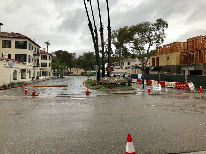
Flooding at Coast Village Road in Montecito.
11:15 a.m.,
Montecito Creek flows Wednesday morning March 21 under East Valley Rd. in Montecito. Nearby are homes that were destroyed from the deadly Jan 9 debris flow.
7:25 a.m.,
Mark Jackson, Meteorologist-in-charge for the Los Angeles area office of the National Weather Service, briefs emergency personnel about the ongoing rain event Wednesday morning at Santa Barbara County Fire’s Headquarters.


No comments:
Post a Comment