Here is a photo I found of the mud flow I believe covering Pilgrim Creek Road from KRON TV
Main stream media glacier stories here:

MT. SHASTA (KRON) — Officials are monitoring a mudflow that has closed roads in Siskiyou County after a glacier broke off Mt. Shasta.
A large mudflow and debris began cascading down the mountain at about 3 p.m. Saturday on the southeastern side of Mt. Shasta, according to the National Weather Service.
The weather service initially issued a flash flood warning Saturday night but downgraded it to a flash flood watch.
Resources have been monitoring since this event began and the flow seems to be receding this morning, according to Andrea Capps, Forest Service spokesperson.
The warning is in effect through 5 p.m. Sunday.
Capps said that while the exact cause hasn’t been determined yet, it is believed that drought conditions “have left Mt Shasta’s glaciers exposed to the sun’s heat.”
“Visitors to Mt. Shasta should be aware that similar conditions could occur in other drainages on Mt. Shasta and that additional mudslides are possible,” Capps said.
Facebook user Seth Fortna posted video showing an area of the mud and debris-strewn terrain and said, “I couldn’t get too close, but you can see how spread out it was.”
Pilgrim Creek Road and Winding Way (Forest Road 31) have been closed.
Officials say that more mudslides could occur in other areas near the mountain and leaving nearby roads closed for a couple of days.
“Water is continuing to accumulate upstream behind the debris flow along the Mud and and Pilgrim creeks and could break free at any time,” the weather service said.
Forest Service officials say motorists should not attempt to drive over the slide area because they say even small amounts of mud and debris can overpower a vehicle.
“A flash flood warning means flash flooding is occurring or is imminent, officials said. Most flood related deaths occur in automobiles. Do not attempt to cross water covered bridges, dips, or low water crossings,” officials warned.
end quote from:
http://dutchsinse.tatoott1009.com/9212014-glacier-breaks-off-mount-shasta-volcano-in-north-california-lahar-mud-flow/
He said at this site he was concerned about earthquake activity on Mt. Saint Helens and Mt. Shasta and other local volcanoes. He thinks the Glacier breaking off is from these small earthquakes on various volanic mountains and not just from sun heating the glaciers up from lack of new snow.
Here is one of the machines trying to clear the debris from the Glacier break:


Here is one of the machines trying to clear the debris from the Glacier break:
Mt Shasta mudflow
Mt Shasta mudflow; a view from up top. Some Forest Services roads remains closed Monday due to a weekend event where a glacier broke off the mountain, send a mudflow down river.
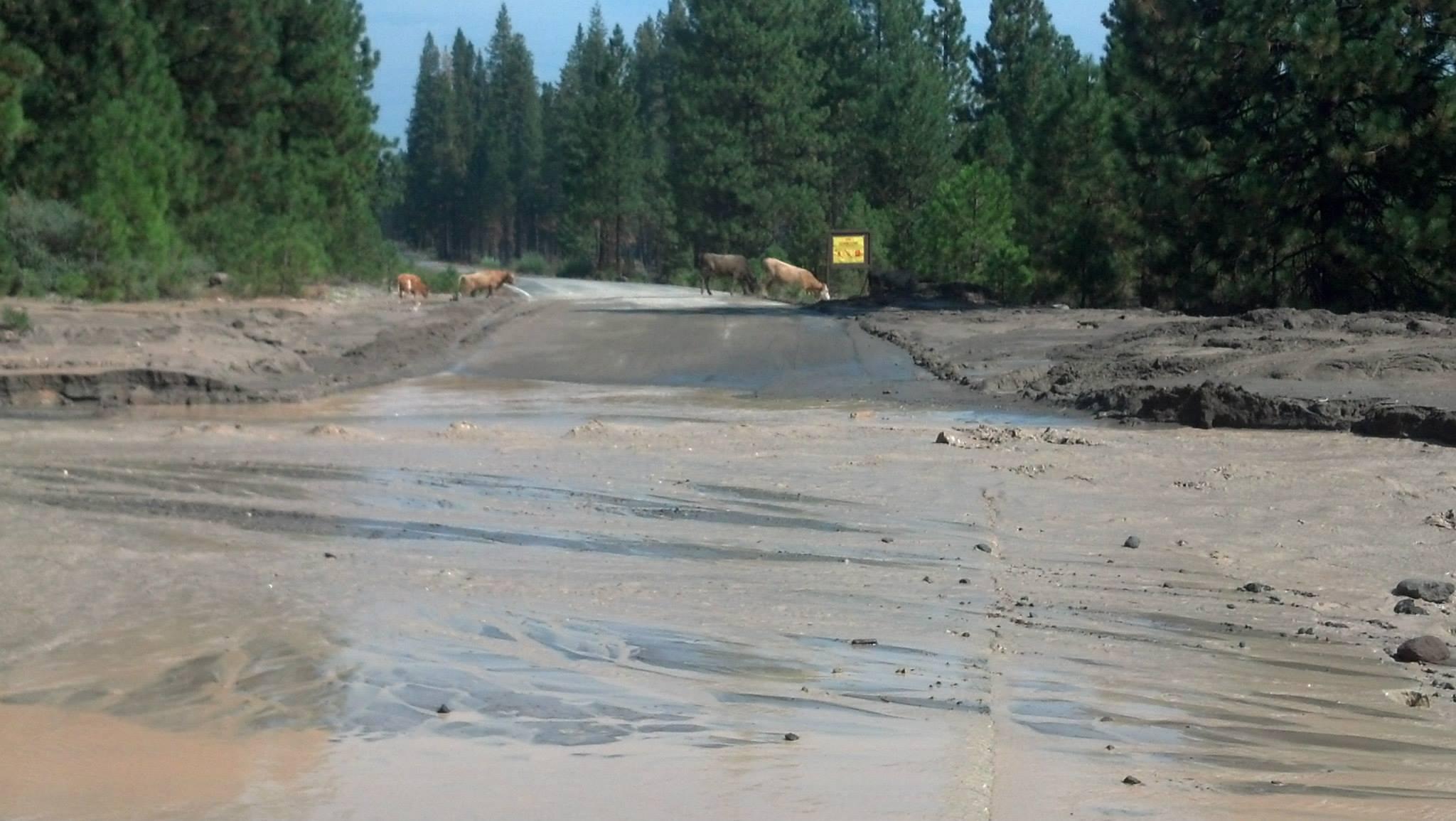
This is one of the roads overrun with mud. You cannot cross this even in a 4 wheel drive because the mud is just too fine because it is volcanic dust mixed with water. You can see likely cattle in the background crossing the road, although I suppose it also could be something else, but it looks a lot like Cattle to me. IT's cattle for sure when I loaded the page I had a plus sign which enlarged the photo for me to see that it is for sure cattle and that the water is flowing by towards the McCloud River.
There used to be a bridge here but now it's buried so I'm not sure what they are going to do in the long run. Also, the water has always been cloudy at this point since I first visited this point around 1979 or 1980. However, McCloud River isn't usually muddy like this from fine volcanic dust like this place usually is. So, that is something new and will likely last for several weeks time on the McCloud River too. the Hearst Family (used to own the Hearst Castle) does or did own a beautiful place on the McCloud River too as this country is very remote. The nearest town of any size is McCloud which is actually a very small town. The city of Mt. Shasta is at least 20 miles or more away from this point along Hiway 89 and Mt. Shasta is I think between 5000 and 7000 people. Redding is about 60 to 80 miles away from here and Ashland about the same in Oregon.
There used to be a bridge here but now it's buried so I'm not sure what they are going to do in the long run. Also, the water has always been cloudy at this point since I first visited this point around 1979 or 1980. However, McCloud River isn't usually muddy like this from fine volcanic dust like this place usually is. So, that is something new and will likely last for several weeks time on the McCloud River too. the Hearst Family (used to own the Hearst Castle) does or did own a beautiful place on the McCloud River too as this country is very remote. The nearest town of any size is McCloud which is actually a very small town. The city of Mt. Shasta is at least 20 miles or more away from this point along Hiway 89 and Mt. Shasta is I think between 5000 and 7000 people. Redding is about 60 to 80 miles away from here and Ashland about the same in Oregon.
Mount Shasta Mudslide Reaches McCloud River
UPDATED | Monday 5 PM
Sediment from the weekend mudslide on Mount Shasta reached Lake McCloud and the lower McCloud River early Monday. The water is likely to stay cloudy for weeks.
The Saturday slide covered two roads near Mount Shasta, and caused the National Weather Service to issue a Flash Flood Watch, which was lifted Sunday evening. State highway 89 remains open.
The Shasta Trinity National Forest says the Konwakiton Glacier on the southeast side of the mountain is probably the source of the debris flow. Pockets of liquid water trapped in glaciers can be released when the glacier either breaks or melts.
The Forest Service says mudslides are not unprecedented, particularly in the Mud Creek drainage where this one happened. And such events are more common in drought years, when glaciers are exposed to the sun for longer periods.
Crews are working to reopen Pilgrim Creek Road and Forest Service Road 31; visitors were warned to stay out of the area while the unstable conditions persist.
And those conditions could be aggravated by precipitation forecast for later in the week. Warm rains can also trigger mudslides.
end quote from:
http://ijpr.org/post/mount-shasta-mudslide-reaches-mccloud-river
No comments:
Post a Comment