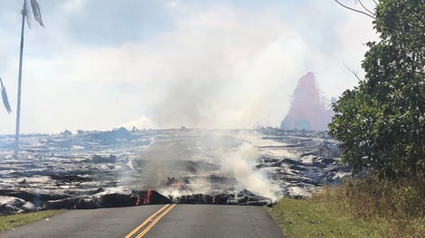
This is a partial quote from the following website. It shows where the lava river heads to the ocean. If you have been to this area like I have many times I believe the main road to the National park from Pahoa, and Hilo where the main airport on this side of the island is now has been severed by the path of the Lava river. But, likely there are paved or dirt back roads where people can still get to the national Park nearby as well even though I have no idea when it will be open again because of the acidic Laze which could destroy people's lungs trying to breathe in this area now. If you want to be able to breathe in the future you need to NOT be downwind of the LAZE (Lava Haze).or (Lava Fog) which is acidic and lung burning by nature. This is why you see helicopters always flying up wind of the Laze so they can still breathe fresh air coming off the ocean from thousands of miles of open sea. IN 1974 I lived in Hilo, Hawaii nearby so I know this area a lot. Also, I have flown here more than once and also I flew into Kona and snorkeled on the Kona side within the last couple of years and visited Hilo, Pahoa and Volcanoes National park in this area then by car.
begin partial quote from:
https://gizmodo.com/kilauea-volcano-has-turned-this-hawaiian-shore-into-an-1826859435
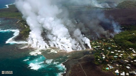
The video of the shoreline was taken as the helicopter traveled from north to south. The devastation seems to go on forever, but the affected shoreline is roughly a mile long. As the video shows, no stretch within this area has been spared—it’s total devastation. Small litoral explosions, when lava from the channel hits the ocean, can be seen, along with several plumes ot toxic laze.


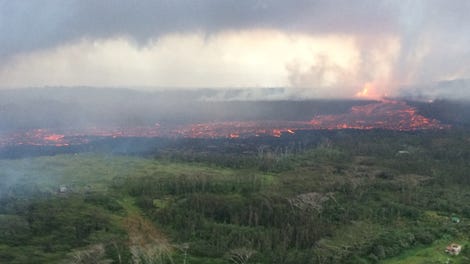
Meanwhile, a second video released by the USGS shows what’s going on at Halema‘uma‘u crater at Kīlauea’s summit. This drone footage, captured on June 13, is providing a unique look at the gigantic hole, which began erupting in mid-May. The UAV footage allows officials and the public a close look at what is clearly a very hazardous area.
The perimeter around the crater can be seen slumping inward and downward. The deepest part of the crater is now about 1,000 feet (300 m) below the rim. The flat section at the bottom of the crater is the former Halema‘uma‘u crater floor, which has dropped at least 300 feet (100 m) over the past several weeks. Ground cracks near the crater rim can be seen cutting across the parking lot, the former site of a visitor overlook (which was closed back in 2008).
The scenes along the Hawaiian shoreline certainly look awful, but the good news is that this region will eventually rebound once Kilauea settles down. The beautiful islands of Hawaii wouldn’t exist if it weren’t for these volcanic processes, as problematic as they are to those who live there.
[USGS]
ABOUT THE AUTHOR


No comments:
Post a Comment