


Why all this rain? Blame a strong 'atmospheric river' known as the 'pineapple express'


Lompoc firefighter Chris Martinez, part of a regional search-and-rescue task force, scouts Montecito Creek at the East Valley bridge on Wednesday. (Al Seib / Los Angeles Times)
California is facing the strongest storm of 2018, coming on something called an “atmospheric river” or a “pineapple express.” Here’s an explainer.
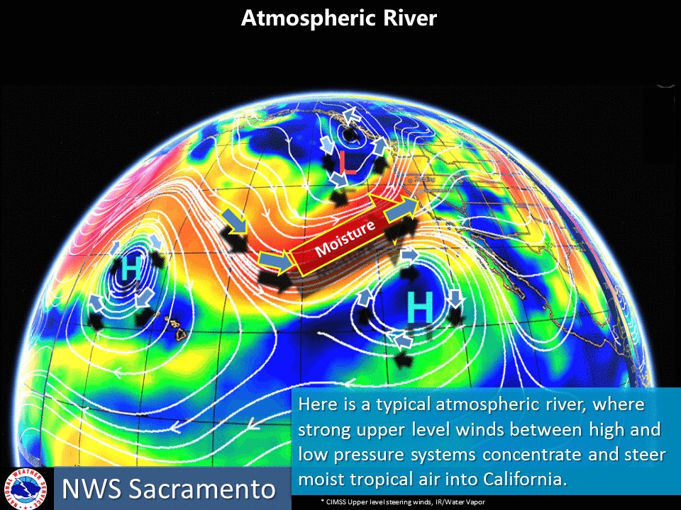
What is an atmospheric river?
Atmospheric river storms are long plumes of water vapor that can pour over from the Pacific Ocean through California.

Why is it called an atmospheric river?
It carries so much water, it’s like a river in the sky.
A strong atmospheric river can carry 7½ to 15 times the average flow of liquid water at the Mississippi River’s mouth.
What's an Atmospheric River? They are long, narrow regions in the atmosphere that transport large amounts of the water vapor from the tropics. #cawx #atmosphericriver
What is a pineapple express?
A pineapple express is a particular kind of strong atmospheric river. It brings in water vapor from the tropical Pacific Ocean, near Hawaii, to the American West Coast.

Is this week’s storm in California a pineapple express?
Yes.
Are atmospheric rivers good or bad?
Atmospheric rivers can be good and bad.
They’re good, because most are weak. Weak ones bring in the rain and snow that Californians rely on for water supply.
Just a few atmospheric river events can bring West Coast states such as California between one-third to one-half of annual precipitation.
And the bad?
They can be destructive when they are too strong.
Atmospheric rivers can bring storms that create intense rainfall and floods, and trigger mudslides and deaths.


This really is a spectacular, photogenic storm. #AtmosphericRiver becoming entrained in warm sector of deepening cut-off low to the west, exhibiting "textbook" #PineappleExpress structure. Can't take my eyes off the satellite imagery. #CAwx #CAwater
What’s an example of a recent atmospheric river?
The storm that came to Southern California on Jan. 9 that triggered catastrophic mudslides in Montecito, killing 21 people, came on an atmospheric river.
Is this atmospheric river bad?
It might be. UCLA climate scientist Daniel Swain wrote on his California Weather Blogthat this storm is the strongest of the year. Heavy precipitation is expected from California’s central coast and southern Sierra Nevada all the way south to the Southern California coastal plain.
“This storm concerns me at least as much as the January 9th storm and perhaps somewhat more given the higher expected rain totals, broader region affected, and the potential for the [atmospheric river] to stall out somewhere inopportune,” Swain wrote.
A big problem is that very heavy precipitation appears to be focused on Santa Barbara and possibly Ventura County, which endured recent wildfires. In a burned area, a wildfire can make soils repellant to water, creating a floodlike flow on the ground that picks up rock and debris, which is known as a debris flow.
What should people living in the recently burned areas of Santa Barbara and Ventura counties expect?
The National Weather Service has warned that debris flows — powerful flows of water and mud — are likely in recently burned areas. Forecasters warned that 5 to 10 inches of rain are expected in the foothills and mountains.
How fast is the rain expected to fall?
There’s a slight chance of thunderstorms, which could produce rainfall rates of up to 1 inch per hour in burn areas. “Significant debris flows likely!” the weather service tweeted.
The U.S. Geological Survey has said that based on past data, rainfall rates of half an inch per hour can produce debris flows in Santa Barbara County burn areas.
Highest rainfall rates for this event across the Thomas, Whittier, and Sherpa burn areas expected Thursday morning.. A slight chance of thunderstorms with rates possibly up to 1 inch per hour. Significant debris flows likely! #CAstorm #cawx #LArain #ThomasFire #Montecito
When is the worst to come?
Heavy rain is expected Wednesday night for San Luis Obispo County. Santa Barbara, Ventura and Los Angeles counties are expected to get hit Thursday.

Latest details on storm. Most dangerous conditions still to come. #SanLuisObispo Counties Tonight. #SantaBarbara #Ventura #LosAngeles Counties on Thursday. Stay alert! #cawx #CAstorm #LARain
What’s the connection between atmospheric rivers and California’s history of devastating floods?
Most of California’s major historical floods have come from slow-moving or stalled atmospheric rivers, Swain wrote.
Why is this storm stronger than the Jan. 9 event?
It’ll probably bring more precipitation than the Jan. 9 event, Swain said.
So will this storm certainly produce worse floods in Santa Barbara and Ventura counties?
Not necessarily, but it’s important to be on guard.
“The Montecito event was largely the product of an extremely intense localized downpour,” Swain wrote. “But the risk during this storm will extend across a much broader region, and there is a real possibility of major flash flooding and large debris flows/mudslides.”
What about Northern California?
Northern California will get rain and wind, but nothing too extreme, Swain said.
Support our journalism
Please consider subscribing today to support stories like this one. Get full access to our signature journalism for just 99 cents for the first four weeks. Already a subscriber? Your support makes our work possible. Thank you.
UPDATES:
8:00 p.m.: This article was updated to include the latest forecast on how fast the rain was expected to fall and that the heavy rain was forecast to fall on Thursday in Santa Barbara, Ventura and Los Angeles counties.
6 p.m.: This article was updated to include information on how much water vapor is contained in a strong atmospheric river.
This article was originally published at 1 p.m.
end quote from:
http://www.latimes.com/la-me-ln-what-is-an-atmospheric-river-pineapple-express-20180321-htmlstory.html
No comments:
Post a Comment