begin quote from:https://www.cnn.com/2022/07/29/weather/weekend-forecast-heat-drought-floods/index.html
Extreme heat, flash drought and more flash flooding are all on tap this weekend. See if you’re affected


Extreme heat or flooding could affect your weekend.
Heat alerts are extended through Sunday in the Pacific Northwest, flash-drought conditions will worsen across the southern Plains, and the Mid-South is bracing for more weekend rainfall following days of devastating floods.
Oregon and Washington are ending July in the thick of blistering heat, reaching 10 to 20 degrees above average in the central valleys.
While the Northwest is seeing hot temperatures for the first time this summer, the southern Plains have been smothered with intense heat for weeks, sending them into worsening drought and causing agriculture concerns across Texas and Oklahoma.
Just east of the heat wave, Kentucky and Missouri have been battling torrential rainfall and deadly flash floods reaching record river heights, as thunderstorms and rain are predicted to continue.
The desert Southwest has been experiencing a fair share of flooding too, as monsoon season will ramp up thunderstorm chances overnight.
Here is what to expect and where:
A record weeklong heat wave bakes the Northwest
Portland has been flirting with temperatures in the triple digits since Monday, prompting an extension of excessive heat warnings for the region through Sunday evening.
Large portions of central Oregon and Washington will see temperatures pass the century mark Friday and Saturday, before cooling off next week.
Temperatures in Portland, Oregon, are forecast to remain at least in the upper 90s until Sunday, which would make the seven-day heat wave the longest streak above 95 degrees in more than four decades.
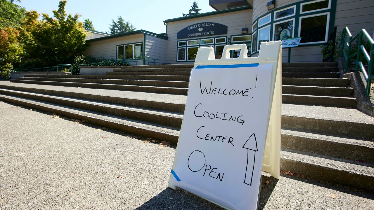
Portland Mayor Ted Wheeler has issued an emergency declaration and cooling centers have been opened in Multnomah County.
Seattle is also on track to reach one of the longest hot-day stretches on record. The current forecast shows temperatures remaining above 90 degrees until at least Saturday, with excessive heat warnings extended until Sunday at 9 p.m.
“Confidence is high (70-80%) chance that it will remain hot in the Willamette Valley and Columbia River Gorge through at least Saturday,” the National Weather Service office in Portland said.
The heat has already proved to be deadly.
As of Thursday afternoon, the Oregon State Medical Examiner’s Office has been informed of five suspected heat-related deaths since the current heat advisory began, Mindy McCartt, communications director for the Oregon State Police told CNN in an email.
Three suspected deaths occurred in Multnomah County on Monday, Wednesday and Thursday; one suspected death in Umatilla County on Tuesday, and there was one possible heat-related death on Thursday in Marion County, McCartt added.
“This designation as a heat-related death is preliminary and further investigation may reveal a cause of death that’s unrelated to hyperthermia. The final determination of the cause of death may not be known for several months after the death,” the statement says.
Excessive heat can be deadly for residents who are unable to cool off. Last year, Oregon reported nearly 100 deaths from a record heat wave, which included an all-time record 116-degree high in Portland.
Only 44% of Seattle residents have AC, making it one of the least-prepared metros for a heat wave, according to a US Census Bureau survey, and poses a greater challenge for those in historically underserved communities of color.
Officials are informing people to call 211 to find the nearest cooling center and to close blinds or curtains to keep homes cool.
Poor air quality has also been a concern in the region. Ground-level ozone, a harmful air pollutant, is expected to increase chances for health problems for susceptible populations over the next week.
Multnomah County, Oregon’s most populous county including, Portland, issued a wood burning curtailment on July 27, triggering burn bans, which will remain in effect “until air quality and weather forecasting conditions improve.”
A cool-down is expected next Monday when temperatures will head back to the mid-80s.
Flash drought worsens in the Plains
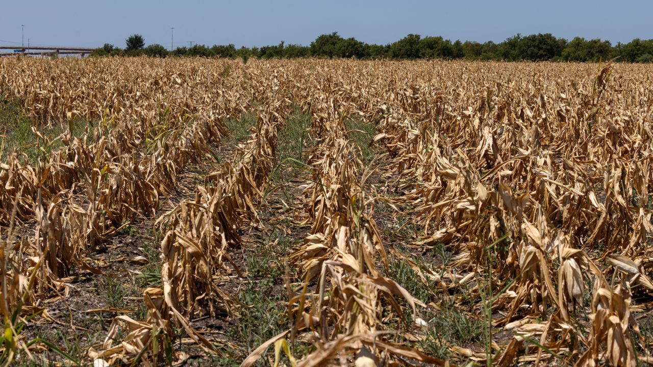
Extreme heat is not only sizzling in the Northwest. Temperatures are continuing to bake the southern Plains, soaking up any remaining moisture.
Dallas has had temperatures above 100 degrees for 13 days in a row, and is just two days away from reaching its second-longest precipitation-free streak on record. Texas is forecast to continue its 100 degree streak and remain dry, for at least the next week.
This will continue to intensify the flash drought which worsened this past week across the Great Plains and Mississippi Valley, according to the latest US Drought monitor report released Thursday morning.
The region has been experiencing temperatures well above normal this summer, resulting in extreme drought for 27 percent of Oklahoma, the second-highest level. Thunderstorm chances ramp up through the weekend, bringing some precipitation to areas most in need.
“Organized storm activity is expected across western and southern Oklahoma, and western north Texas late Friday afternoon into Friday evening. Some storms will be capable of damaging wind gusts,” the weather service office in Norman said.
Prolonged heat and precipitation deficits are pressing the fast-forward button on drought, creating rapidly intensifying dry conditions in the South. Parched soil is preventing agriculture from thriving, which could end up boosting grocery prices in the long run.
“Crop failure and related problems are widespread in the part of the region experiencing flash drought, especially in northeast Texas, eastern and central Oklahoma, and northern Arkansas,” the US Drought Monitor wrote.
McLennan County, where the city of Waco is located, went from 17.5 percent of the county in exceptional drought, the highest level, to over 62 percent this week. Waco, Texas is currently on track to having one of its driest years on record.
The Northeast has also seen reductions in streamflow, poor soil moisture, and water shortages in some areas.
“Severe drought expanded in coverage in eastern Massachusetts, Rhode Island, and eastern Connecticut,” the Drought Monitor reported. “Widespread calls for water conservation occurred from New England to the Hudson Valley and New Jersey, and hay fields struggled in Rhode Island.”
Flooding continues in Missouri, Kentucky and Southwest
On the other hand, an abundance of moisture has had dire consequences. Rainfall, made worse by the same climate change causing severe drought, brought heaps of rainfall to other areas this week. Now, more rain may be on the way.
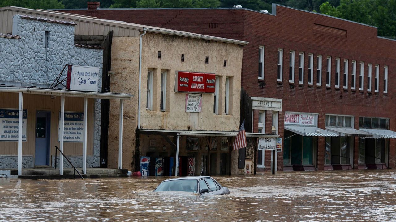
St. Louis, where record rainfall devastated the region on Tuesday, experienced back-to-back flooding events. Part of the city was submerged seven feet from flooding due to excessive rain on Thursday, sending emergency responders to rescue residents from their homes.
And in eastern Kentucky, a rapid onset of rainfall caused catastrophic flash flooding and record river heights.
The Weather Prediction Center has forecast a slight to moderate risk of flash flooding extending from eastern Kentucky into West Virginia through Friday evening as additional showers move across the area. An additional 1-3 inches of rain is possible within the next 24 hours.
“We’re watching (additional rainfall) pretty close, and it’s not going to take too much to cause some additional flooding issues,” Dustin Jordan, science and operations officer at the weather service office in Jackson, Kentucky, told CNN.
A short relief from the storms will keep most Kentucky locations dry on Saturday, but rain chances ramp up again next week. The weather service office in Jackson, Kentucky, predicts at least an inch of additional rainfall Sunday into Monday, especially in far southeast Kentucky and areas closer to the Tennessee and Virginia borders.
River water levels are still in major flood stage (Level 3 of 3) but are forecast to gradually decrease over the next day or two. Numerous roads remain closed, and Jordan said next week’s rain could be focused over areas hit hardest by recent flooding.
“Showers and thunderstorms are possible at times Sunday through Thursday,” the weather service office in Jackson, Kentucky, said. “Heavy rainfall may occur, especially on Sunday and Monday, and could lead to localized flash flooding. Excess rainfall may also contribute to additional river flooding.”
The desert Southwest is under a flash flood watch until Saturday morning as afternoon thunderstorms move into the area. Rainfall could exceed one to two inches per hour in some areas.
“Monsoonal moisture is forecasted to bring showers and thunderstorms to northern Arizona through the weekend and into early next week,” the weather service office in Flagstaff, Arizona, said. “The greatest threats will be the potential of flash flooding due to heavy rain, along with frequent lightning, gusty winds, and small hail.”
The Flagstaff office added northern Arizona has experienced an “above average monsoon season,” which has been improving long-term drought conditions in the region.
CNN’s Paradise Afshar, Jennifer Henderson and Haley Brink contributed to this report.
No comments:
Post a Comment