The 2011 earthquake off the Pacific coast of Tōhoku (東北地方太平洋沖地震, Tōhoku-chihō Taiheiyō Oki Jishin?) was a magnitude 9.0–9.1 (M w ...
2011 Tōhoku earthquake and tsunami
From Wikipedia, the free encyclopedia
2011 Tōhoku earthquake and tsunami

An aerial view of the Sendai region with black smoke coming from the Nippon Oil refinery |
|
|
| Date |
11 March 2011; 6 years ago |
| Origin time |
14:46:24 JST (UTC+09:00) |
| Duration |
6 minutes[1] |
| Magnitude |
9.0–9.1 Mw[2] |
| Depth |
29 km (18 mi) |
| Epicenter |
 38.322°N 142.369°ECoordinates: 38.322°N 142.369°E 38.322°N 142.369°ECoordinates: 38.322°N 142.369°E |
| Type |
Megathrust |
| Areas affected |
Japan (shaking, tsunami)
Pacific Rim (tsunami) |
| Total damage |
Tsunami wave, flooding, landslides, fires, building and infrastructure damage, nuclear incidents including radiation releases |
| Max. intensity |
IX (Violent) |
| Peak acceleration |
2.99 g |
| Tsunami |
Up to 40.5 m (133 ft)
in Miyako, Iwate, Tōhoku |
| Landslides |
Yes |
| Foreshocks |
List of foreshocks and aftershocks of the 2011 Tōhoku earthquake |
| Aftershocks |
11,450 (as of 3 March 2015)[3] |
| Casualties |
15,894 deaths,[4]
6,152 injured,[5]
2,562 people missing[6] |
The
2011 earthquake off the Pacific coast of Tōhoku (東北地方太平洋沖地震 Tōhoku-chihō Taiheiyō Oki Jishin?) was a
magnitude 9.0–9.1 (M
w)
undersea megathrust earthquake off the coast of
Japan that occurred at 14:46
JST (05:46
UTC) on Friday 11 March 2011,
[7][8][9] with the
epicentre approximately 70 kilometres (43 mi) east of the
Oshika Peninsula of
Tōhoku and the
hypocenter at an underwater depth of approximately 29 km (18 mi).
[7][10] The earthquake is also often referred to in Japan as the
Great East Japan earthquake (東日本大震災 Higashi nihon daishinsai?)[11][12][13][fn 1] and also known as the
2011 Tōhoku earthquake,
[27] and the
3.11 earthquake. It was the most powerful
earthquake ever recorded to have hit Japan, and the
fourth most powerful earthquake in the world since modern record-keeping began in 1900.
[9][28][29] The earthquake triggered powerful
tsunami waves that reached heights of up to 40.5 metres (133 ft) in
Miyako in Tōhoku's
Iwate Prefecture,
[30][31] and which, in the
Sendai area, traveled up to 10 km (6 mi) inland.
[32] The earthquake moved
Honshu
(the main island of Japan) 2.4 m (8 ft) east, shifted the Earth on its
axis by estimates of between 10 cm (4 in) and 25 cm (10 in),
[33][34][35] and generated infrasound waves detected in perturbations of the low-orbiting
GOCE satellite.
[36]
On 10 March 2015, a Japanese
National Police Agency report confirmed 15,894 deaths,
[37] 6,152 injured,
[38] and 2,562 people missing
[39] across twenty
prefectures, as well as 228,863 people living away from their home in either temporary housing or due to permanent relocation.
[40]
A 10 February 2014 agency report listed 127,290 buildings totally
collapsed, with a further 272,788 buildings "half collapsed", and
another 747,989 buildings partially damaged.
[41]
The earthquake and tsunami also caused extensive and severe structural
damage in north-eastern Japan, including heavy damage to roads and
railways as well as fires in many areas, and a dam collapse.
[32][42] Japanese Prime Minister Naoto Kan said, "In the 65 years after the end of World War II, this is the toughest and the most difficult crisis for Japan."
[43] Around 4.4 million households in northeastern Japan were left without electricity and 1.5 million without water.
[44]
The tsunami caused
nuclear accidents, primarily the
level 7 meltdowns at three reactors in the
Fukushima Daiichi Nuclear Power Plant complex, and the associated evacuation zones affecting hundreds of thousands of residents.
[45][46] Many electrical generators were taken down, and at least three nuclear reactors
suffered explosions
due to hydrogen gas that had built up within their outer containment
buildings after cooling system failure resulting from the loss of
electrical power. Residents within a 20 km (12 mi) radius of the
Fukushima Daiichi Nuclear Power Plant and a 10 km (6.2 mi) radius of the
Fukushima Daini Nuclear Power Plant were evacuated.
Early estimates placed insured losses from the earthquake alone at US$14.5 to $34.6 billion.
[47] The
Bank of Japan offered
¥15 trillion (US$183 billion) to the banking system on 14 March in an effort to normalize market conditions.
[48] The
World Bank's estimated economic cost was US$235 billion, making it the costliest natural disaster in world history.
[49][50]
Earthquake
The 9.1
magnitude (
Mw)
undersea megathrust earthquake occurred on 11 March 2011 at 14:46
JST (05:46 UTC) in the north-western Pacific Ocean at a relatively shallow depth of 32 km (20 mi),
[7][51] with its
epicenter approximately 72 km (45 mi) east of the
Oshika Peninsula of
Tōhoku, Japan, lasting approximately six minutes.
[1][7] The earthquake was initially reported as 7.9 M
w by the USGS before it was quickly upgraded to 8.8 M
w, then to 8.9 M
w,
[52] and then finally to 9.0 M
w.
[8][53] Sendai was the nearest major city to the earthquake, 130 km (81 mi) from the epicenter; the earthquake occurred 373 km (232 mi) from
Tokyo.
[7]
The main earthquake was preceded by a number of large
foreshocks, with hundreds of
aftershocks reported. One of the first major foreshocks was a 7.2 M
w
event on 9 March, approximately 40 km (25 mi) from the epicenter of 11
March earthquake, with another three on the same day in excess of 6.0 M
w.
[7][54] Following the main earthquake on 11 March, a 7.4 M
w aftershock was reported at 15:08 JST (6:06 UTC), succeeded by a 7.9 M
w at 15:15 JST (6:16 UTC) and a 7.7 M
w at 15:26 JST (6:26 UTC).
[55] Over eight hundred aftershocks of magnitude 4.5 M
w or greater have occurred since the initial quake,
[56] including one on 26 October 2013 (local time) of magnitude 7.1 M
w.
[57] Aftershocks follow
Omori's Law,
which states that the rate of aftershocks declines with the reciprocal
of the time since the main quake. The aftershocks will thus taper off in
time, but could continue for years.
[58]
One minute before the earthquake was felt in Tokyo, the
Earthquake Early Warning system, which includes more than 1,000
seismometers in Japan, sent out warnings of impending strong shaking to millions. It is believed that the early warning by the
Japan Meteorological Agency (JMA) saved many lives.
[59][60] The warning for the general public was delivered about 8 seconds after the first
P wave
was detected, or about 31 seconds after the earthquake occurred.
However, the estimated intensities were smaller than the actual ones in
some places in Kanto and Tōhoku regions. This was thought to be because
of smaller estimated earthquake magnitude, smaller estimated fault
plane, shorter estimated fault length, not having considered the shape
of the fault, etc.
[61]
There were also cases where large differences between estimated
intensities by the Earthquake Early Warning system and the actual
intensities occurred in the aftershocks and triggered earthquakes.
[62]
Geology
Map of the Tōhoku earthquake and aftershocks on 11–14 March
Hypocentral region boundaries (Source: The Japanese Headquarters for Earthquake Research Promotion)
This megathrust earthquake was a recurrence of the mechanism of the earlier
869 Sanriku earthquake, which has been estimated as having a magnitude of at least 8.4 M
w, which also created a large tsunami that inundated the Sendai plain.
[63][64]
Three tsunami deposits have been identified within the Holocene
sequence of the plain, all formed within the last 3,000 years,
suggesting an 800 to 1,100 year recurrence interval for large
tsunamigenic earthquakes. In 2001 it was reckoned that there was a high
likelihood of a large tsunami hitting the Sendai plain as more than
1,100 years had then elapsed.
[65] In 2007, the probability of an earthquake with a magnitude of M
w 8.1–8.3 was estimated as 99% within the following 30 years.
[66]
This earthquake occurred where the
Pacific Plate is
subducting under the plate beneath northern Honshu; which plate is a matter of debate amongst scientists.
[34][67]
The Pacific plate, which moves at a rate of 8 to 9 cm (3.1 to 3.5 in)
per year, dips under Honshu's underlying plate building large amounts of
elastic energy. This motion pushes the upper plate down until the
accumulated stress causes a seismic slip-rupture event. The break caused
the sea floor to rise by several metres.
[67]
A quake of this magnitude usually has a rupture length of at least
500 km (310 mi) and generally requires a long, relatively straight fault
surface. Because the plate boundary and
subduction zone in the area of the Honshu rupture is not very straight, it is unusual for the magnitude of its earthquake to exceed 8.5 M
w; the magnitude of this earthquake was a surprise to some seismologists.
[68] The
hypocentral region of this earthquake extended from offshore
Iwate Prefecture to offshore
Ibaraki Prefecture.
[69] The
Japanese Meteorological Agency
said that the earthquake may have ruptured the fault zone from Iwate to
Ibaraki with a length of 500 km (310 mi) and a width of 200 km
(120 mi).
[70][71] Analysis showed that this earthquake consisted of a set of three events.
[72] Other major earthquakes with tsunamis struck the
Sanriku Coast region
in 1896 and
in 1933.
The source area of this earthquake has a relatively high coupling
coefficient surrounded by areas of relatively low coupling coefficients
in the west, north, and south. From the averaged coupling coefficient of
0.5–0.8 in the source area and the seismic moment, it was estimated
that the slip deficit of this earthquake was accumulated over a period
of 260–880 years, which is consistent with the recurrence interval of
such great earthquakes estimated from the tsunami deposit data. The
seismic moment of this earthquake accounts for about 93% of the
estimated cumulative moment from 1926 to March 2011. Hence, earthquakes
with magnitudes about 7 since 1926 in this area only had released part
of the accumulated energy. In the area near the trench, the coupling
coefficient is high, which could act as the source of the large tsunami.
[73]
Most of the foreshocks are interplate earthquakes with thrust-type
focal mechanisms. Both interplate and intraplate earthquakes appeared in
the aftershocks offshore Sanriku coast with considerable proportions.
[74]
The strong ground motion registered at the maximum of 7 on the
Japan Meteorological Agency seismic intensity scale in
Kurihara,
Miyagi Prefecture.
[75] Three other prefectures—
Fukushima,
Ibaraki and
Tochigi—recorded an upper 6 on the JMA scale. Seismic stations in
Iwate,
Gunma,
Saitama and
Chiba Prefecture measured a lower 6, recording an upper 5 in Tokyo.
In
Russia, the main shock could be felt in
Yuzhno-Sakhalinsk (MSK 4) and
Kurilsk (MSK 4). The aftershock at 06:25 UTC could be felt in
Yuzhno-Kurilsk (MSK 5) and Kurilsk (MSK 4).
[76]
Energy
The
surface energy of the seismic waves from the earthquake was calculated to be at
1.9×10¹⁷ joules,
[77] which is nearly double that of the 9.1 M
w 2004 Indian Ocean earthquake and tsunami
that killed 230,000 people. If harnessed, the seismic energy from this
earthquake would power a city the size of Los Angeles for an entire
year.
[58] The
seismic moment (M
0), which represents a physical size for the event, was calculated by the USGS at 3.9×10
22 joules,
[78] slightly less than the 2004 Indian Ocean quake.
Japan's National Research Institute for Earth Science and Disaster Prevention (NIED) calculated a
peak ground acceleration of 2.99
g (29.33 m/s
2).
[79][fn 2]
The largest individual recording in Japan was 2.7 g, in Miyagi
Prefecture, 75 km from the epicentre; the highest reading in the Tokyo
metropolitan area was 0.16 g.
[82]
Geophysical effects
Portions of northeastern Japan shifted by as much as 2.4 metres (7 ft 10 in) closer to
North America,
[33][34] making some sections of Japan's landmass wider than before.
[34] Those areas of Japan closest to the epicenter experienced the largest shifts.
[34]
A 400-kilometre (250 mi) stretch of coastline dropped vertically by 0.6
metres (2 ft 0 in), allowing the tsunami to travel farther and faster
onto land.
[34] One early estimate suggested that the Pacific plate may have moved westward by up to 20 metres (66 ft),
[83] and another early estimate put the amount of slippage at as much as 40 m (130 ft).
[84]
On 6 April the Japanese coast guard said that the quake shifted the
seabed near the epicenter 24 metres (79 ft) and elevated the seabed off
the coast of Miyagi Prefecture by 3 metres (9.8 ft).
[85] A report by the
Japan Agency for Marine-Earth Science and Technology, published in
Science on 2 December 2011, concluded that the seabed in the area between the epicenter and the
Japan Trench
moved 50 metres (160 ft) east-southeast and rose about 7 metres (23 ft)
as a result of the quake. The report also stated that the quake had
caused several major landslides on the seabed in the affected area.
[86]
The Earth's
axis shifted by estimates of between 10 cm (4 in) and 25 cm (10 in).
[33][34][35] This deviation led to a number of small planetary changes, including the
length of a day, the
tilt of the Earth, and the
Chandler wobble.
[35] The speed of the Earth's rotation increased, shortening the day by 1.8
microseconds due to the redistribution of Earth's mass.
[87] The axial shift was caused by the redistribution of mass on the Earth's surface, which changed the planet's
moment of inertia. Because of
conservation of angular momentum, such changes of
inertia result in small changes to the Earth's rate of rotation.
[88] These are expected changes
[35] for an earthquake of this magnitude.
[33][87] The earthquake also generated infrasound waves detected by perturbations in the orbit of the
GOCE satellite, which thus
serendipitously became the first seismograph in orbit.
[36]
Soil liquefaction was evident in areas of
reclaimed land around Tokyo, particularly in
Urayasu,
[89][90] Chiba City,
Funabashi,
Narashino (all in
Chiba Prefecture) and in the
Koto,
Edogawa,
Minato,
Chūō, and
Ōta Wards of Tokyo. Approximately 30 homes or buildings were destroyed and 1,046 other buildings were damaged to varying degrees.
[91] Nearby
Haneda Airport, built mostly on reclaimed land, was not damaged.
Odaiba also experienced liquefaction, but damage was minimal.
[92]
Shinmoedake, a volcano in
Kyushu,
erupted three days after the earthquake. The volcano had previously
erupted in January 2011; it is not known if the later eruption was
linked to the earthquake.
[93] In
Antarctica, the seismic waves from the earthquake were reported to have caused the
Whillans Ice Stream to slip by about 0.5 metres (1 ft 8 in).
[94]
The first sign international researchers had that the earthquake
caused such a dramatic change in the Earth's rotation came from the
United States Geological Survey which monitors Global Positioning
Satellite stations across the world. The Survey team had several GPS
monitors located near the scene of the earthquake. The GPS station
located nearest the epicenter moved almost 4 m (13 ft). This motivated
government researchers to look into other ways the earthquake may have
had large scale effects on the planet. Calculations at NASA's Jet
Propulsion Laboratory determined that the Earth's rotation was changed
by the earthquake to the point where the days are now 1.8
microseconds shorter.
[95]
Aftershocks
Japan has experienced over 1,000 aftershocks since the earthquake, with 80 registering over magnitude 6.0 M
w and several of which have been over magnitude 7.0 M
w.
A magnitude 7.4 M
w at 15:08 (JST), 7.9 M
w at 15:15 and a 7.7 M
w quake at 15:26 all occurred on 11 March.
[96]
A month later, a
major aftershock struck offshore on 7 April with a magnitude of 7.1 M
w. Its epicenter was underwater, 66 km (41 mi) off the coast of Sendai. The
Japan Meteorological Agency assigned a magnitude of 7.4 M
JMA, while the
U.S. Geological Survey lowered it to 7.1 M
w.
[97]
At least four people were killed, and electricity was cut off across
much of northern Japan including the loss of external power to
Higashidōri Nuclear Power Plant and
Rokkasho Reprocessing Plant.
[98][99][100]
Four days later on 11 April, another
magnitude 7.1 Mw aftershock struck Fukushima, causing additional damage and killing a total of three people.
[101][102]
On 7 December 2012 a
large aftershock of magnitude 7.3 Mw caused a minor tsunami, and again on 26 October 2013 small tsunami waves were recorded after a 7.1 M
w aftershock.
[103]
As of 16 March 2012 aftershocks continued, totaling 1887 events over
magnitude 4.0; a regularly updated map showing all shocks of magnitude
4.5 and above near or off the east coast of Honshu in the last seven
days
[104] showed over 20 events.
[105]
As of 11 March 2016 there had been 869 aftershocks of 5.0 M
w or greater, 118 of 6.0 M
w or greater, and 9 over 7.0 M
w as reported by the Japanese Meteorological Agency.
[106]
The number of aftershocks was associated with decreased health across Japan.
[107]
Tsunami
Energy map of the tsunami from
NOAA
An upthrust of 6 to 8 metres along a 180-km-wide seabed at 60 km offshore from the east coast of Tōhoku
[108] resulted in a major
tsunami that brought destruction along the
Pacific
coastline of Japan's northern islands. Thousands of lives were lost
when entire towns were devastated. The tsunami propagated throughout the
Pacific Ocean region reaching the entire Pacific coast of North and
South America from
Alaska to
Chile.
Warnings were issued and evacuations carried out in many countries
bordering the Pacific. However, while the tsunami affected many of these
places, the extent was minor.
[109][110][111]
Chile's Pacific coast, one of the furthest from Japan at about
17,000 km (11,000 mi) distant, was struck by waves 2 m (6.6 ft) high,
[112][113][114] compared with an estimated wave height of 38.9 metres (128 ft) at Omoe peninsula, Miyako city, Japan.
[31]
Japan
The
tsunami warning issued by the
Japan Meteorological Agency was the most serious on its warning scale; it was rated as a "major tsunami", being at least 3 m (9.8 ft) high.
[115] The actual height prediction varied, the greatest being for Miyagi at 6 m (20 ft) high.
[116] The tsunami inundated a total area of approximately 561 km
2 (217 sq mi) in Japan.
[117]
Water column height on 11 March 2011 at
DART Station, 690 NM southeast of Tokyo
The earthquake took place at 14:46 JST (UTC 05:46) around 67 km
(42 mi) from the nearest point on Japan's coastline, and initial
estimates indicated the tsunami would have taken 10 to 30 minutes to
reach the areas first affected, and then areas farther north and south
based on the geography of the coastline.
[118][119] Just over an hour after the earthquake at 15:55 JST, a tsunami was observed flooding
Sendai Airport, which is located near the coast of
Miyagi Prefecture,
[120][121] with waves sweeping away cars and planes and flooding various buildings as they traveled inland.
[122][123] The impact of the tsunami in and around Sendai Airport was filmed by an
NHK News helicopter, showing a number of vehicles on local roads trying to escape the approaching wave and being engulfed by it.
[124] A 4-metre-high (13 ft) tsunami hit
Iwate Prefecture.
[125] Wakabayashi Ward in Sendai was also particularly hard hit.
[126] At least 101 designated tsunami evacuation sites were hit by the wave.
[127]
Like the
2004 Indian Ocean earthquake and tsunami,
the damage by surging water, though much more localized, was far more
deadly and destructive than the actual quake. Entire towns were
destroyed in tsunami-hit areas in Japan, including 9,500 missing in
Minamisanriku;
[128] one thousand bodies had been recovered in the town by 14 March 2011.
[129]
Among several factors causing the high death toll from the tsunami,
one was the unexpectedly large size of the water surge. The tsunami
walls at several of the affected cities were based on much smaller
tsunami heights. Also, many people caught in the tsunami thought that
they were located on high enough ground to be safe.
[130]
Large parts of
Kuji and the southern section of
Ōfunato including the port area were almost entirely destroyed.
[131][132] Also largely destroyed was
Rikuzentakata, where the tsunami was three storeys high.
[133][134][135] Other cities destroyed or heavily damaged by the tsunami include
Kamaishi,
Miyako,
Ōtsuchi, and
Yamada (in Iwate Prefecture),
Namie,
Sōma and
Minamisōma (in Fukushima Prefecture) and
Shichigahama,
Higashimatsushima,
Onagawa,
Natori,
Ishinomaki, and
Kesennuma (in Miyagi Prefecture).
[136][137][138][139][140][141][142] The most severe effects of the tsunami were felt along a 670-kilometre-long (420 mi) stretch of coastline from
Erimo, Hokkaido, in the north to
Ōarai, Ibaraki, in the south, with most of the destruction in that area occurring in the hour following the earthquake.
[143] Near Ōarai, people captured images of a huge
whirlpool that had been generated by the tsunami.
[144] The tsunami washed away the sole bridge to Miyatojima, Miyagi, isolating the island's 900 residents.
[145] A two-metre-high tsunami hit
Chiba Prefecture about 2½ hours after the quake, causing heavy damage to cities such as
Asahi.
[146]
On 13 March 2011, the
Japan Meteorological Agency
(JMA) published details of tsunami observations recorded around the
coastline of Japan following the earthquake. These observations included
tsunami maximum readings of over 3 m (9.8 ft) at the following
locations and times on 11 March 2011, following the earthquake at 14:46
JST:
[147]
Peak tsunami wave height summits, color-coded with red representing most severe
Many areas were also affected by waves of 1 to 3 metres (3.3 to
9.8 ft) in height, and the JMA bulletin also included the caveat that
"At some parts of the coasts, tsunamis may be higher than those observed at the observation sites."
The timing of the earliest recorded tsunami maximum readings ranged
from 15:12 to 15:21, between 26 and 35 minutes after the earthquake had
struck. The bulletin also included initial tsunami observation details,
as well as more detailed maps for the coastlines affected by the tsunami
waves.
[148][149]
JMA also reported offshore tsunami height recorded by
telemetry from
moored GPS wave-height meter buoys as follows:
[150]
On 25 March 2011, Port and Airport Research Institute (PARI) reported tsunami height by visiting the port sites as follows:
[151]
NOAA animation of the tsunami's propagation
- Port of Hachinohe – 5–6 m (16–19 ft)
- Port of Hachinohe area – 8–9 m (26–29 ft)
- Port of Kuji – 8–9 m (26–29 ft)
- Port of Kamaishi – 7–9 m (23–30 ft)
- Port of Ōfunato – 9.5 m (31 ft)
- Run up height, port of Ōfunato area – 24 m (79 ft)
- Fishery port of Onagawa – 15 m (50 ft)
- Port of Ishinomaki – 5 m (16 ft)
- Shiogama section of Shiogama-Sendai port – 4 m (13 ft)
- Sendai section of Shiogama-Sendai port – 8 m (26 ft)
- Sendai Airport area – 12 m (39 ft)
The tsunami at Ryōri Bay (綾里白浜), Ōfunato was about 30 m high. Fishing equipment was scattered on the high cliff above the bay.
[152] At
Tarō, Iwate, the tsunami reached a height of 37.9 m (124 ft) up the slope of a mountain some 200 m (656 ft) away from the
coastline.
[153] Also, at the slope of a nearby mountain from 400 m (1,312 ft) away at Aneyoshi fishery port (姉吉漁港) of Omoe peninsula (重茂半島) in
Miyako, Iwate,
Tokyo University of Marine Science and Technology found estimated tsunami run up height of 38.9 m (127 ft).
[31] This height is deemed the record in Japan historically, as of reporting date, that exceeds 38.2 m (125 ft) from the
1896 Meiji-Sanriku earthquake.
[154]
It was also estimated that the tsunami reached heights of up to 40.5
metres (133 ft) in Miyako in Tōhoku's Iwate Prefecture. The inundated
areas closely matched those of the
869 Sanriku tsunami.
[155]
A Japanese government study found that 58% of people in coastal areas
in Iwate, Miyagi, and Fukushima prefectures heeded tsunami warnings
immediately after the quake and headed for higher ground. Of those who
attempted to evacuate after hearing the warning, only five percent were
caught in the tsunami. Of those who didn't heed the warning, 49% were
hit by the water.
[156]
Elsewhere across the Pacific
Shortly after the earthquake, the
Pacific Tsunami Warning Center
(PTWC) in Hawaii issued tsunami watches and announcements for locations
in the Pacific. At 07:30 UTC, PTWC issued a widespread tsunami warning
covering the entire Pacific Ocean.
[157][158] Russia evacuated 11,000 residents from coastal areas of the
Kuril Islands.
[159] The United States
National Tsunami Warning Center issued a tsunami warning for the coastal areas in most of
California, all of
Oregon, and the western part of
Alaska, and a tsunami advisory covering the Pacific coastlines of most of Alaska, and all of
Washington and
British Columbia, Canada.
[160][161] In
California and
Oregon,
up to 2.4-metre-high (7.9 ft) tsunami surges hit some areas, damaging
docks and harbors and causing over US$10 million in damage.
[162] In
Curry County, Oregon $7 million in damage occurred including the destruction of 1,100 m (3,600 ft) of dockspace at the
Brookings harbor; the county has received over $1 million in
FEMA emergency grants.
[163] Surges of up to 1 m (3.3 ft) hit
Vancouver Island in Canada
[161]
prompting some evacuations, and causing boats to be banned from the
waters surrounding the island for 12 hours following the wave strike,
leaving many island residents in the area without means of getting to
work.
[164][165]
Fishing boats moved to higher ground in anticipation of tsunami arrival, in
Pichilemu, Chile
In the
Philippines,
waves up to 0.5 m (1.6 ft) high hit the eastern seaboard of the
country. Some houses along the coast in Jayapura, Indonesia were
destroyed.
[166] Authorities in
Wewak,
East Sepik,
Papua New Guinea evacuated 100 patients from the city's Boram Hospital
before it was hit by the waves, causing an estimated US$4 million in
damage.
[167]
Hawaii estimated damage to public infrastructure alone at US$3 million,
with damage to private properties, including resort hotels such as
Four Seasons Resort Hualalai, estimated at tens of millions of dollars.
[168] It was reported that a 1.5-metre-high (4.9 ft) wave completely submerged
Midway Atoll's reef inlets and Spit Island, killing more than 110,000 nesting
seabirds at the
Midway Atoll National Wildlife Refuge.
[169] Some other South Pacific countries, including
Tonga and New Zealand, and U.S. territories
American Samoa and
Guam, experienced larger-than-normal waves, but did not report any major damage.
[170] However, in Guam some roads were closed off and people were evacuated from low-lying areas.
[171]
Along the Pacific Coast of
Mexico and South America, tsunami surges were reported, but in most places caused little or no damage.
[172] Peru reported a wave of 1.5 m (5 ft) and more than 300 homes damaged.
[172] The surge in Chile was large enough to damage more than 200 houses,
[173] with waves of up to 3 m (9.8 ft).
[174][175] In the
Galápagos Islands,
260 families received assistance following a 3-metre (9.8 ft) surge
which arrived 20 hours after the earthquake, after the tsunami warning
had been lifted.
[176][177] There was a great deal of damage to buildings on the islands and one man was injured but there were no reported fatalities.
[176][178]
The tsunami broke
icebergs off the
Sulzberger Ice Shelf in
Antarctica,
13,000 kilometres (8,100 mi) away. The main iceberg measured 9.5 by 6.5
kilometres (5.9 mi × 4.0 mi) (approximately the area of
Manhattan Island) and about 80 metres (260 ft) thick. A total of 125 square kilometres (48 sq mi; 31,000 acres) of ice broke away.
[179][180]
As of April 2012, wreckage from the tsunami spread around the oceans, including a
soccer ball which was found in Alaska
[181] and a Japanese motorcycle found in British Columbia, Canada.
[182]
Land subsidence
The
Geospatial Information Authority of Japan reported land
subsidence based on the height of
triangulation stations in the area measured by
GPS as compared to their previous values from 14 April 2011.
[183]
- Miyako, Iwate – 0.50 m (1.64 ft)
- Yamada, Iwate – 0.53 m (1.73 ft)
- Ōtsuchi, Iwate – 0.35 m (1.14 ft)[184]
- Kamaishi, Iwate – 0.66 m (2.16 ft)
- Ōfunato, Iwate – 0.73 m (2.39 ft)
- Rikuzentakata, Iwate – 0.84 m (2.75 ft)
- Kesennuma, Miyagi – 0.74 m (2.42 ft)
- Minamisanriku, Miyagi – 0.69 m (2.26 ft)
- Oshika Peninsula, Miyagi – 1.2 m (3.93 ft)[184]
- Ishinomaki, Miyagi – 0.78 m (2.55 ft)
- Higashimatsushima, Miyagi – 0.43 m (1.41 ft)
- Iwanuma, Miyagi – 0.47 m (1.54 ft)
- Sōma, Fukushima – 0.29 m (0.95 ft)
Scientists say that the subsidence is permanent. As a result, the
communities in question are now more susceptible to flooding during high
tides.
[185]
Casualties
Memorials amongst the ruins, Natori
The
National Police Agency has confirmed 15,894 deaths,
[186] 6,152 injured,
[187] and 2,562 people missing
[188] across twenty
prefectures.
[41]
Of the 13,135 fatalities recovered by 11 April 2011, 12,143 or 92.5%
died by drowning. Victims aged 60 or older accounted for 65.2% of the
deaths, with 24% of total victims being in their 70s.
[189]
As of March 2012, Japanese police data showed that 70% of the 3,279
still missing were aged 60 or over, all found, including 893 in their
70s and 577 in their 80s. Of the total confirmed victims, 14,308
drowned, 667 were crushed to death or died from internal injuries, and
145 perished from burns.
[190]
Tsunami damage between Sendai and Sendai Bay
Save the Children
reports that as many as 100,000 children were uprooted from their
homes, some of whom were separated from their families because the
earthquake occurred during the school day.
[191] 236 children were orphaned in the prefectures of
Iwate,
Miyagi and
Fukushima by the disaster;
[192][193] 1,580 children lost either one or both parents,
[194] 846 in Miyagi, 572 in Iwate, and 162 in Fukushima.
[195] The quake and tsunami killed 378 elementary, middle-school, and high school students and left 158 others missing.
[196] One elementary school in
Ishinomaki, Miyagi, Okawa Elementary, lost 74 of 108 students and 10 of 13 teachers and staff.
[197][198][199]
The Japanese Foreign Ministry has confirmed the deaths of nineteen foreigners.
[200] Among them are two English teachers from the United States affiliated with the
Japan Exchange and Teaching Program;
[201] a Canadian missionary in
Shiogama;
[202] and citizens of China, North and South Korea, Taiwan, Pakistan and the Philippines.
By 9:30 UTC on 11 March,
Google Person Finder, which was previously used in the
Haitian,
Chilean, and
Christchurch, New Zealand earthquakes, was collecting information about survivors and their locations.
[203][204] The
Next of Kin Registry (
NOKR) is assisting the Japanese government in locating next of kin for those missing or deceased.
[205]
Japanese funerals
are normally elaborate Buddhist ceremonies that entail cremation. The
thousands of bodies, however, exceeded the capacity of available
crematoriums and
morgues, many of them damaged,
[206][207] and there were shortages of both kerosene—each cremation requires 50 litres—and
dry ice for preservation.
[208] The single crematorium in
Higashimatsushima, for example, could only handle four bodies a day, although hundreds were found there.
[209] Governments and the military were forced to bury many bodies in hastily dug
mass graves with rudimentary or no rites, although relatives of the deceased were promised that they would be cremated later.
[210]
The tsunami is reported to have caused several deaths outside Japan. One man was killed in
Jayapura,
Papua, Indonesia after being swept out to sea.
[211] A man who is said to have been attempting to photograph the oncoming tsunami at the mouth of the
Klamath River, south of
Crescent City, California, was swept out to sea.
[212][213][214] His body was found on 2 April along Ocean Beach in
Fort Stevens State Park, Oregon, some 330 miles (530 km) to the north.
[215][216]
Noted individual fatalities within Japan included 103-year-old
Takashi Shimokawara,
holder of the world athletics records in the men's shot put, discus
throw and javelin throw for the over-100s age category. He was killed by
the earthquake and tsunami at
Kamaishi, Iwate.
[217]
As of 27 May 2011, three
Japan Ground Self-Defense Force members had died while conducting relief operations in Tōhoku.
[218]
As of March 2012, the Japanese government had recognized 1,331 deaths
as indirectly related to the earthquake, such as caused by harsh living
conditions after the disaster.
[219] As of 30 April 2012, 18 people had died and 420 had been injured while participating in disaster recovery or clean-up efforts.
[220]
Damage and effects
Panorama of the Hirota Peninsula in Rikuzentakata swept away
Aerial photo of Minato, devastated by both the earthquake and subsequent tsunami
The degree and extent of damage caused by the earthquake and
resulting tsunami were enormous, with most of the damage being caused by
the tsunami. Video footage of the towns that were worst affected shows
little more than piles of rubble, with almost no parts of any structures
left standing.
[221] Estimates of the cost of the damage range well into the tens of billions of
US dollars; before-and-after
satellite photographs of devastated regions show immense damage to many regions.
[222][223]
Although Japan has invested the equivalent of billions of dollars on
anti-tsunami seawalls which line at least 40% of its 34,751 km
(21,593 mi) coastline and stand up to 12 m (39 ft) high, the tsunami
simply washed over the top of some seawalls, collapsing some in the
process.
[224]
A fire which broke out in
Tokyo after the earthquake
Japan's
National Police Agency
said on 3 April 2011, that 45,700 buildings were destroyed and 144,300
were damaged by the quake and tsunami. The damaged buildings included
29,500 structures in Miyagi Prefecture, 12,500 in Iwate Prefecture and
2,400 in Fukushima Prefecture.
[225] Three hundred hospitals with 20 beds or more in Tōhoku were damaged by the disaster, with 11 being completely destroyed.
[226] The earthquake and tsunami created an estimated 24–25 million tons of rubble and debris in Japan.
[227][228]
An estimated 230,000 automobiles and trucks were damaged or destroyed
in the disaster. As of the end of May 2011, residents of Iwate, Miyagi,
and Fukushima prefectures had requested deregistration of 15,000
vehicles, meaning that the owners of those vehicles were writing them
off as unrepairable or unsalvageable.
[229]
Ports
Ship and crane damage at Sendai port
All of Japan's ports were briefly shut down after the earthquake,
though the ones in Tokyo and southwards soon re-opened. Fifteen ports
were located in the disaster zone. The north eastern ports of Hachinohe,
Sendai, Ishinomaki and Onahama were destroyed, while the
Port of Chiba (which serves the hydrocarbon industry) and Japan's ninth-largest container port at
Kashima
were also affected, though less severely. The ports at Hitachinaka,
Hitachi, Soma, Shiogama, Kesennuma, Ofunato, Kamashi and Miyako were
also damaged and closed to ships.
[230] All 15 ports reopened to limited ship traffic by 29 March 2011.
[231] A total of 319 fishing ports, about 10% of Japan's fishing ports, were damaged in the disaster.
[232] Most were restored to operating condition by 18 April 2012.
[233]
The
Port of Tokyo
suffered slight damage; the effects of the quake included visible smoke
rising from a building in the port with parts of the port areas being
flooded, including
soil liquefaction in
Tokyo Disneyland's parking lot.
[234][235]
Dams and water problems
|
|
This section needs to be updated. Please update this article to reflect recent events or newly available information. (March 2013) |
The
Fujinuma irrigation dam in
Sukagawa ruptured,
[236] causing flooding and washing away five homes.
[237] Eight people were missing and four bodies were discovered by the morning.
[238][239] Reportedly, some locals had attempted to repair leaks in the dam before it completely
failed.
[240] On 12 March 252 dams were inspected and it was discovered that six
embankment dams had shallow cracks on their crests. The reservoir at one concrete
gravity dam suffered a small non-serious
slope failure.
All damaged dams are functioning with no problems. Four dams within the
quake area were unreachable. When the roads clear, experts will be
dispatched to conduct further investigations.
[241]
In the immediate aftermath of the calamity, at least 1.5 million households were reported to have lost access to water supplies.
[44][242] By 21 March 2011, this number fell to 1.04 million.
[243]
Electricity
A map of Japan's electricity distribution network shows the geographic divide between 50 hertz systems and 60 hertz systems
According to the Japanese trade ministry, around 4.4 million households served by
Tōhoku Electric Power (TEP) in northeastern Japan were left without electricity.
[244] Several nuclear and conventional power plants went offline after the earthquake, reducing TEPCO's total capacity by 21 GW.
[245] Rolling blackouts began on 14 March due to power shortages caused by the earthquake.
[246] The
Tokyo Electric Power Company (TEPCO), which normally provides approximately 40
GW
of electricity, announced that it could only provide about 30 GW. This
was because 40% of the electricity used in the greater Tokyo area was
supplied by reactors in the
Niigata and
Fukushima prefectures.
[247] The reactors at the
Fukushima Daiichi and
Fukushima Dai-ni
plants were automatically taken offline when the first earthquake
occurred and sustained major damage related to the earthquake and
subsequent tsunami. Rolling blackouts of approximately three hours were
experienced throughout April and May while TEPCO scrambled to find a
temporary power solution. The blackouts affected Tokyo,
Kanagawa, Eastern
Shizuoka,
Yamanashi,
Chiba,
Ibaraki,
Saitama,
Tochigi, and
Gunma prefectures.
[248]
Voluntary reduced electricity use by consumers in the Kanto area helped
reduce the predicted frequency and duration of the blackouts.
[249] By 21 March 2011, the number of households in the north without electricity fell to 242,927.
[243]
Damage to electricity transmission lines
Tōhoku Electric Power was not able to provide the Kanto region with
additional power, because TEP's power plants were also damaged in the
earthquake.
Kansai Electric Power Company
(Kepco) cannot share electricity, because its system operates at 60
hertz, whereas TEPCO and TEP operate their systems at 50 hertz; this is
due to early industrial and infrastructure development in the 1880s that
left Japan without a unified national
power grid.
[250]
Two substations, one in Shizuoka Prefecture and one in Nagano
Prefecture, were able to convert between frequencies and transfer
electricity from Kansai to Kanto and Tōhoku, but their capacity to do so
is limited to 1 GW. With the damage to so many power plants, it may be
years before a long-term solution can be found.
[251]
In an effort to help alleviate the shortage, three steel
manufacturers in the Kanto region contributed electricity produced by
their in-house conventional power stations to TEPCO for distribution to
the general public.
Sumitomo Metal Industries could produce up to 500 MW,
JFE Steel 400 MW, and
Nippon Steel 500 MW of electric power
[252]
Auto and auto parts makers in Kanto and Tōhoku agreed in May 2011 to
operate their factories on Saturdays and Sundays and close on Thursdays
and Fridays to assist in alleviating the electricity shortage during the
summer of 2011.
[253]
Oil, gas and coal
Fire at the Cosmo Oil refinery in
Ichihara
A 220,000-barrel (35,000 m
3)-per-day
[254] oil refinery of
Cosmo Oil Company was set on fire by the quake at
Ichihara,
Chiba Prefecture, to the east of Tokyo.
[255][256] It was extinguished after ten days, injuring six people, and destroying storage tanks.
[257] Others halted production due to safety checks and power loss.
[258][259] In Sendai, a 145,000-barrel (23,100 m
3)-per-day refinery owned by the largest refiner in Japan,
JX Nippon Oil & Energy, was also set ablaze by the quake.
[254] Workers were evacuated,
[260] but tsunami warnings hindered efforts to extinguish the fire until 14 March, when officials planned to do so.
[254]
An analyst estimates that consumption of various types of oil may increase by as much as 300,000 barrels (48,000 m
3) per day (as well as LNG), as back-up power plants burning
fossil fuels try to compensate for the loss of 11 GW of Japan's nuclear power capacity.
[261][262]
The city-owned plant for importing
liquefied natural gas in Sendai was severely damaged, and supplies were halted for at least a month.
[263]
In addition to refining and storage, several power plants were
damaged. These include Sendai #4, New-Sendai #1 and #2, Haranomachi #1
and #2, Hirono #2 and #4 and Hitachinaka #1.
[264]
Nuclear power plants
The
Fukushima Daiichi,
Fukushima Daini,
Onagawa Nuclear Power Plant and
Tōkai nuclear power stations, consisting of a total eleven reactors, were
automatically shut down following the earthquake.
[265] Higashidōri, also on the northeast coast, was already shut down for a periodic inspection. Cooling is needed to remove
decay heat after a
Generation II reactor
has been shut down, and to maintain spent fuel pools. The backup
cooling process is powered by emergency diesel generators at the plants
and at
Rokkasho nuclear reprocessing plant.
[266]
At Fukushima Daiichi and Daini, tsunami waves overtopped seawalls and
destroyed diesel backup power systems, leading to severe problems at
Fukushima Daiichi, including three large explosions and radioactive
leakage. Subsequent analysis found that many Japanese nuclear plants,
including Fukushima Daiichi, were not adequately protected against
tsunami.
[267] Over 200,000 people were evacuated.
[268]
7 April aftershock caused the loss of external power to Rokkasho
Reprocessing Plant and Higashidori Nuclear Power Plant but backup
generators were functional.
Onagawa Nuclear Power Plant
lost 3 of 4 external power lines and temporarily lost cooling function
in its spent fuel pools for "20 to 80 minutes". A spill of "up to
3.8 litres" of radioactive water also occurred at Onagawa following the
aftershock.
[269]
A report by the
IAEA in 2012 found that the
Onagawa Nuclear Power Plant,
the closest nuclear plant to the epicenter of the 2011 earthquake and
tsunami, had remained largely undamaged. The plant's 3 reactors
automatically shut down without damage and all safety systems functioned
as designed. The plant's 14-metre-high (46 ft) seawall successfully
withstood the tsunami.
[270]
Europe's
Energy Commissioner Günther Oettinger addressed the European Parliament on 15 March, explaining that the nuclear disaster was an "apocalypse".
[271]
As the nuclear crisis entered a second month, experts recognized that
Fukushima Daiichi is not the worst nuclear accident ever, but it is the
most complicated. Nuclear experts stated that Fukushima will go down in
history as the second-worst nuclear accident ever.... while not as bad
as
Chernobyl disaster, worse than
Three Mile Island accident.
It could take months or years to learn how damaging the release of
dangerous isotopes has been to human health and food supplies, and the
surrounding countryside.
[272]
Later analysis indicated three reactors at
Fukushima I (Units 1, 2, and 3) had suffered meltdowns and continued to leak coolant water,
[45]
and by summer the Vice-minister for Economy, Trade and Industry, the
head of the Nuclear and Industrial Safety Agency, and the head of the
Agency for Natural Resources and Energy, had lost their jobs.
[273]
Fukushima meltdowns
Loose livestock roam the evacuation zone
Japan declared a state of emergency following the failure of the cooling system at the
Fukushima Daiichi Nuclear Power Plant, resulting in the evacuation of nearby residents.
[274][275][276] Officials from the Japanese
Nuclear and Industrial Safety Agency reported that radiation levels inside the plant were up to 1,000 times normal levels,
[277] and that radiation levels outside the plant were up to 8 times normal levels.
[278] Later, a state of emergency was also declared at the
Fukushima Daini nuclear power plant about 11 km (6.8 mi) south.
[279] This brought the total number of problematic reactors to six.
[280]
It was reported that radioactive iodine was detected in the tap water
in Fukushima, Tochigi, Gunma, Tokyo, Chiba, Saitama, and Niigata, and
radioactive cesium in the tap water in Fukushima, Tochigi and Gunma.
[281][282][283] Radioactive cesium, iodine, and strontium
[284] were also detected in the soil in some places in Fukushima. There may be a need to replace the contaminated soil.
[285] Many radioactive hotspots were found outside the evacuation zone, including Tokyo.
[286] Food products were also found contaminated by radioactive matter in several places in Japan.
[287] On 5 April 2011, the government of the
Ibaraki Prefecture banned the fishing of
sand lance after discovering that this species was contaminated by radioactive
cesium above legal limits.
[288] As late as July 2013 slightly elevated levels of radioactivity were found in beef on sale at Tokyo markets.
[289]
Incidents elsewhere
A fire occurred in the turbine section of the
Onagawa Nuclear Power Plant following the earthquake.
[266][290] The blaze was in a building housing the turbine, which is sited separately from the plant's reactor,
[274] and was soon extinguished.
[291] The plant was shut down as a precaution.
[292]
On 13 March the lowest-level state of emergency was declared regarding the Onagawa plant as radioactivity readings temporarily
[293] exceeded allowed levels in the area of the plant.
[294][295]
Tōhoku Electric Power Co. stated this may have been due to radiation
from the Fukushima Daiichi nuclear accidents but was not from the
Onagawa plant itself.
[296]
As a result of 7 April aftershock, Onagawa Nuclear Power Plant lost 3
of 4 external power lines and lost cooling function for as much as
80 minutes. A spill of a couple of litres of radioactive water occurred
at Onagawa.
[269]
The number 2 reactor at
Tōkai Nuclear Power Plant was shut down automatically.
[265] On 14 March it was reported that a cooling system pump for this reactor had stopped working;
[297]
however, the Japan Atomic Power Company stated that there was a second
operational pump sustaining the cooling systems, but that two of three
diesel generators used to power the cooling system were out of order.
[298]
Wind power
None of
Japan's commercial wind turbines, totaling over 2300 MW in
nameplate capacity, failed as a result of the earthquake and tsunami, including the Kamisu offshore wind farm directly hit by the tsunami.
[299]
Transport
A highway bridge damaged and severed
Japan's transport network suffered severe disruptions. Many sections of
Tōhoku Expressway serving northern Japan were damaged. The expressway did not reopen to general public use until 24 March 2011.
[300][301] All railway services were suspended in Tokyo, with an estimated 20,000 people stranded at major stations across the city.
[302] In the hours after the earthquake, some train services were resumed.
[303] Most Tokyo area train lines resumed full service by the next day—12 March.
[304] Twenty thousand stranded visitors spent the night of 11–12 March inside
Tokyo Disneyland.
[305]
A tsunami wave flooded
Sendai Airport at 15:55 JST,
[120] about 1 hour after the initial quake, causing severe damage.
Narita and
Haneda Airport both briefly suspended operations after the quake, but suffered little damage and reopened within 24 hours.
[235] Eleven airliners bound for Narita were diverted to nearby
Yokota Air Base.
[306][307]
Various train services around Japan were also canceled, with
JR East suspending all services for the rest of the day.
[308] Four trains on coastal lines were reported as being out of contact with operators; one, a four-car train on the
Senseki Line, was found to have derailed, and its occupants were rescued shortly after 8 am the next morning.
[309] Minami-Kesennuma Station on the
Kesennuma Line was obliterated save for its platform;
[310] 62 of 70 (31 of 35) JR East train lines suffered damage to some degree;
[231]
in the worst-hit areas, 23 stations on 7 lines were washed away, with
damage or loss of track in 680 locations and the 30-km radius around the
Fukushima Daiichi nuclear plant unable to be assessed.
[311]
There were no derailments of
Shinkansen bullet train services in and out of Tokyo, but their services were also suspended.
[235] The
Tōkaidō Shinkansen resumed limited service late in the day and was back to its normal schedule by the next day, while the
Jōetsu and
Nagano Shinkansen resumed services late on 12 March. Services on
Yamagata Shinkansen resumed with limited numbers of trains on 31 March.
[312]
Derailments were minimized because of an early warning system that
detected the earthquake before it struck. The system automatically
stopped all high-speed trains, which minimized the damage.
[313]
The
Tōhoku Shinkansen
line was worst hit, with JR East estimating that 1,100 sections of the
line, varying from collapsed station roofs to bent power pylons, will
need repairs. Services on the Tōhoku Shinkansen partially resumed only
in Kantō area on 15 March, with one round-trip service per hour between
Tokyo and
Nasu-Shiobara,
[314] and Tōhoku area service partially resumed on 22 March between
Morioka and
Shin-Aomori.
[315] Services on
Akita Shinkansen resumed with limited numbers of trains on 18 March.
[316] Service between Tokyo and
Shin-Aomori
was restored by May, but at lower speeds due to ongoing restoration
work; the pre-earthquake timetable was not reinstated until late
September.
[317]
The rolling blackouts brought on by the crises at the nuclear power
plants in Fukushima had a profound effect on the rail networks around
Tokyo starting on 14 March. Major railways began running trains at
10–20 minute intervals, rather than the usual 3–5 minute intervals,
operating some lines only at rush hour and completely shutting down
others; notably, the
Tōkaidō Main Line,
Yokosuka Line,
Sōbu Main Line and
Chūō-Sōbu Line were all stopped for the day.
[318]
This led to near-paralysis within the capital, with long lines at train
stations and many people unable to come to work or get home. Railway
operators gradually increased capacity over the next few days, until
running at approximately 80% capacity by 17 March and relieving the
worst of the passenger congestion.
Telecommunications
Damaged utility pole in Ishinomaki
Cellular and landline phone service suffered major disruptions in the affected area.
[319]
Immediately after the earthquake cellular communication was jammed
across much of Japan due to a surge of network activity. On the day of
the quake, American broadcaster NPR was unable to reach anyone in Sendai
with working phone or Internet.
[320]
Internet services were largely unaffected in areas where basic
infrastructure remained, despite the earthquake having damaged portions
of several
undersea cable systems landing in the affected regions; these systems were able to reroute around affected segments onto redundant links.
[321][322] Within Japan, only a few websites were initially unreachable.
[323] Several
Wi-Fi hotspot providers reacted to the quake by providing free access to their networks,
[323] and some American telecommunications and
VoIP companies such as
AT&T,
Sprint,
Verizon,
[324] T-Mobile[325] and VoIP companies such as
netTALK[326] and
Vonage[327] have offered free calls to (and in some cases, from) Japan for a limited time, as did Germany's
Deutsche Telekom.
[328]
Defense
Matsushima Air Field of the
Japan Self-Defense Force in Miyagi Prefecture was struck by the tsunami, flooding the base and resulting in damage to all 18
Mitsubishi F-2 fighter jets of the 21st Fighter Training Squadron.
[329][330][331]
12 of the aircraft were scrapped, while the remaining 6 were slated for
repair at a cost of 80 billion yen ($1 billion), exceeding the original
cost of the aircraft.
[332]
Space center
JAXA (Japan Aerospace Exploration Agency) evacuated the
Tsukuba Space Center in
Tsukuba, Ibaraki. The Center, which houses a control room for part of the
International Space Station, was shut down and some damage was reported.
[333][334]
The Tsukuba control center resumed full operations for the space
station's Kibo laboratory and the HTV cargo craft on 21 March 2011.
[335]
Cultural properties
754
cultural properties were damaged across nineteen prefectures, including five
National Treasures (at
Zuigan-ji,
Ōsaki Hachiman-gū,
Shiramizu Amidadō, and
Seihaku-ji); 160
Important Cultural Properties (including at
Sendai Tōshō-gū, the
Kōdōkan, and
Entsū-in, with its
western decorative motifs); one hundred and forty-four
Monuments of Japan (including
Matsushima,
Takata-matsubara,
Yūbikan, and the
Site of Tagajō); six
Groups of Traditional Buildings; and four
Important Tangible Folk Cultural Properties. Stone monuments at the UNESCO
World Heritage Site:
Shrines and Temples of Nikkō were toppled.
[336][337][338] In Tokyo, there was damage to
Koishikawa Kōrakuen,
Rikugien,
Hamarikyū Onshi Teien, and the walls of
Edo Castle.
[339] Information on the condition of collections held by museums, libraries and archives is still incomplete.
[340] There was no damage to the
Historic Monuments and Sites of Hiraizumi in Iwate Prefecture, and the recommendation for their inscription on the
UNESCO World Heritage List in June was seized upon as a symbol of international recognition and recovery.
[341]
Aftermath
Rescue operations in the floodwaters in downtown
Ishinomaki
The aftermath of the earthquake and tsunami included both a
humanitarian crisis and a major economic impact. The tsunami resulted in
over 340,000 displaced people in the Tōhoku region, and shortages of
food, water, shelter, medicine and fuel for survivors. In response the
Japanese government mobilized the Self-Defence Forces (under Joint Task
Force – Tōhoku, led by Lieutenant General
Eiji Kimizuka),
while many countries sent search and rescue teams to help search for
survivors. Aid organizations both in Japan and worldwide also responded,
with the Japanese Red Cross reporting $1 billion in donations. The
economic impact included both immediate problems, with industrial
production suspended in many factories, and the longer term issue of the
cost of rebuilding which has been estimated at ¥10 trillion
($122 billion). In comparison to the
1995 Great Hanshin earthquake, the East Japan earthquake brought serious damage to an extremely wide range.
[342]
The aftermath of the twin disasters also left Japan's coastal cities
and towns with nearly 25 million tons of debris. In Ishinomaki alone,
there were 17 trash collection sites 180 metres long and at least 4.5
metres high. An official in the city's government trash disposal
department estimated that it would take three years to empty these
sites.
[343]
In April 2015, authorities off the coast of Oregon discovered debris
that is thought to be from a boat destroyed during the tsunami. Cargo
contained yellowtail jack fish, a species that lives off the coast of
Japan, still alive. KGW estimates that more than 1 million tons of
debris still remain in the Pacific Ocean.
[344]
Humanitarian response
Japanese students collecting funds for the victims of the 2011 Tōhoku earthquake and tsunami at the
University of Pécs,
Hungary
Emergency vehicles staging in the ruins of Sukuiso, Japan following the tsunami
According to Japan's foreign ministry, 116 countries and 28
international organizations offered assistance. Japan specifically
requested assistance from teams from
Australia,
New Zealand,
South Korea, and the
United States.
[345]
Media coverage
Anti-nuclear protest following the disaster
Japan's national public broadcaster,
NHK, and
Japan Satellite Television suspended their usual programming to provide ongoing coverage of the situation.
[346] Other nationwide Japanese and international TV networks also broadcast uninterrupted coverage of the disaster.
Ustream Asia broadcast live feeds of NHK,
Tokyo Broadcasting System,
Nippon TV,
Fuji TV,
TV Asahi,
TV Tokyo,
Tokyo MX,
TV Kanagawa, and
CNN on the Internet starting on 12 March 2011.
[347] YokosoNews,
an Internet webcast in Japan, dedicated its broadcast to the latest
news gathered from Japanese news stations, translating them in real time
to English.
[348]
It was noted that the Japanese news media has been at times overly
cautious to avoid panic and reliance on confusing statements by experts
and officials.
[349]
In this national crisis, the Japanese government provided
Japanese Sign Language (JSL) interpreting at the press conferences related to the earthquake and tsunami.
[350] Television broadcasts of the press conferences of
Prime Minister Naoto Kan and
Chief Cabinet Secretary Yukio Edano included simultaneous JSL interpreters standing next to the Japanese flag on the same platform.
[351]
According to
Jake Adelstein,
most Japanese media accepted and parroted the misinformation put out by
the Japanese government and TEPCO about the unfolding Fukushima nuclear
crisis. Notable exceptions, according to Adelstein, were newspapers
Sankei Shimbun and
Chunichi Shimbun
which questioned the accuracy of the information coming from the
government and TEPCO. Because of the unquestioning nature of most
Japanese media to hold to the "party line", many Japanese mid-level
officials and experts spoke to foreign media to get their opinions and
observations publicized.
[352]
Atsushi Funahashi, director of
Nuclear Nation notes that "when the overseas media was calling Fukushima a '
meltdown,' the Japanese government and media waited two months before admitting it."
[353]
Nine days after the earthquake hit, a
visualization and
sonification were uploaded to
YouTube allowing listeners to hear the earthquake as it unfolded in time. Two days of seismic activity made available by the
IRIS Consortium
were compressed into two minutes of sound. The large number of views
made the video one of the most popular examples of sonification on the
web.
[354]
Also, following the earthquake, for the first time in Japanese
history, the Emperor addressed the nation in a pre-recorded television
broadcast.
[355][356]
Scientific and research response
Seismologists anticipated a very large quake would strike in the same place as the
1923 Great Kantō earthquake — in the
Sagami Trough, southwest of Tokyo.
[357][358] The Japanese government had tracked plate movements since 1976 in preparation for the so-called
Tokai earthquake, predicted to take place in that region.
[359]
However, occurring as it did 373 km (232 mi) north east of Tokyo, the
Tōhoku earthquake came as a surprise to seismologists. While the
Japan Trench was known for creating large quakes, it had not been expected to generate quakes above an 8.0 magnitude.
[358][359]
The quake gave scientists the opportunity to collect a large amount
of data so as to model in great detail the seismic events that took
place.
[33]
This data is expected to be used in a variety of ways, providing as it
does unprecedented information about how buildings respond to shaking,
and other effects.
[360] Gravimetric data from the quake has been used to create a model for
increased warning time compared to seismic models, as gravity fields travel faster than seismic waves.
[361]
Researchers have also analysed the economic effects of this
earthquake and have developed models of the nationwide propagation via
interfirm supply networks of the shock originated in Tōhoku region.
[362][363]
Researchers soon after the full extent of the disaster was known
launched a project to gather all digital material relating to the
disaster into an online searchable archive to form the basis of future
research into the events during and after the disaster. The
Japan Digital Archive is presented in English and Japanese and is hosted at the
Reischauer Institute of Japanese Studies at
Harvard University in Boston, Massachusetts. Some of the first research to come from the archive was a 2014
paper from the Digital Methods Initiative in Amsterdam about patterns of
Twitter usage around the time of the disaster.
After the 2011 disaster the UNISDR,
United Nations International Strategy for Disaster Reduction, held its
World Conference on Disaster Risk Reduction in Tohoku in March 2015, which produced the
Sendai Framework
document to guide efforts by international development agencies to act
before disasters instead of reacting to them after the fact. At this
time
Japan's Disaster Management Office (Naikakufu Bosai Keikaku) published a bi-lingual guide in Japanese and English,
Disaster Management in Japan,
to outline the several varieties of natural disaster and the
preparations being made for the eventuality of each. In the fall of 2016
Japan's
National Research Institute for Earth Science and Disaster Resilience (NIED; Japanese abbreviation, Bosai Kaken; full name Bousai Kagaku Gijutsu Kenkyusho) launched the online interactive "
Disaster Chronology Map for Japan, 416–2013" (map labels in Japanese) to display in visual form the location, disaster time, and date across the islands.
See also
Fukushima radiation comparison to other incidents and standards, with
graph of recorded radiation levels and specific accident events. (Note: Does not include all radiation readings from Fukushima Daini site)
Notes


 Tokyo
Tokyo A seismogram recorded in Massachusetts, USA
 The 9.1 magnitude (Mw) undersea megathrust earthquake occurred on 11 March 2011 at 14:46 JST (05:46 UTC) in the north-western Pacific Ocean at a relatively shallow depth of 32 km (20 mi),[7][51] with its epicenter approximately 72 km (45 mi) east of the Oshika Peninsula of Tōhoku, Japan, lasting approximately six minutes.[1][7] The earthquake was initially reported as 7.9 Mw by the USGS before it was quickly upgraded to 8.8 Mw, then to 8.9 Mw,[52] and then finally to 9.0 Mw.[8][53] Sendai was the nearest major city to the earthquake, 130 km (81 mi) from the epicenter; the earthquake occurred 373 km (232 mi) from Tokyo.[7]A visual depiction of the type of faulting that caused the main tremor, low-angle thrusting on a west-dipping fault plane
 Map of the Tōhoku earthquake and aftershocks on 11–14 March
 This megathrust earthquake was a recurrence of the mechanism of the earlier 869 Sanriku earthquake, which has been estimated as having a magnitude of at least 8.4 Mw, which also created a large tsunami that inundated the Sendai plain.[63][64] Three tsunami deposits have been identified within the Holocene sequence of the plain, all formed within the last 3,000 years, suggesting an 800 to 1,100 year recurrence interval for large tsunamigenic earthquakes. In 2001 it was reckoned that there was a high likelihood of a large tsunami hitting the Sendai plain as more than 1,100 years had then elapsed.[65] In 2007, the probability of an earthquake with a magnitude of Mw 8.1–8.3 was estimated as 99% within the following 30 years.[66]Hypocentral region boundaries (Source: The Japanese Headquarters for Earthquake Research Promotion)
 The surface energy of the seismic waves from the earthquake was calculated to be at 1.9×10¹⁷ joules,[77] which is nearly double that of the 9.1 Mw 2004 Indian Ocean earthquake and tsunami that killed 230,000 people. If harnessed, the seismic energy from this earthquake would power a city the size of Los Angeles for an entire year.[58] The seismic moment (M0), which represents a physical size for the event, was calculated by the USGS at 3.9×10²² joules,[78] slightly less than the 2004 Indian Ocean quake.Damage to the antenna of Tokyo Tower
 The Earth's axis shifted by estimates of between 10 cm (4 in) and 25 cm (10 in).[33][34][35] This deviation led to a number of small planetary changes, including the length of a day, the tilt of the Earth, and the Chandler wobble.[35] The speed of the Earth's rotation increased, shortening the day by 1.8 microseconds due to the redistribution of Earth's mass.[87] The axial shift was caused by the redistribution of mass on the Earth's surface, which changed the planet's moment of inertia. Because of conservation of angular momentum, such changes of inertia result in small changes to the Earth's rate of rotation.[88] These are expected changes[35] for an earthquake of this magnitude.[33][87] The earthquake also generated infrasound waves detected by perturbations in the orbit of the GOCE satellite, which thus serendipitously became the first seismograph in orbit.[36]Soil liquefaction in Kōtō, Tokyo
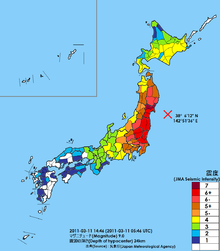 The first sign international researchers had that the earthquake caused such a dramatic change in the Earth's rotation came from the United States Geological Survey which monitors Global Positioning Satellite stations across the world. The Survey team had several GPS monitors located near the scene of the earthquake. The GPS station located nearest the epicenter moved almost 4 m (13 ft). This motivated government researchers to look into other ways the earthquake may have had large scale effects on the planet. Calculations at NASA's Jet Propulsion Laboratory determined that the Earth's rotation was changed by the earthquake to the point where the days are now 1.8 microseconds shorter.[95]Map of seismic intensity observations resulting from mainshock
 An upthrust of 6 to 8 metres along a 180-km-wide seabed at 60 km offshore from the east coast of Tōhoku[108] resulted in a major tsunami that brought destruction along the Pacific coastline of Japan's northern islands. Thousands of lives were lost when entire towns were devastated. The tsunami propagated throughout the Pacific Ocean region reaching the entire Pacific coast of North and South America from Alaska to Chile. Warnings were issued and evacuations carried out in many countries bordering the Pacific. However, while the tsunami affected many of these places, the extent was minor.[109][110][111] Chile's Pacific coast, one of the furthest from Japan at about 17,000 km (11,000 mi) distant, was struck by waves 2 m (6.6 ft) high,[112][113][114] compared with an estimated wave height of 38.9 metres (128 ft) at Omoe peninsula, Miyako city, Japan.[31]Energy map of the tsunami from NOAA
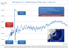 The earthquake took place at 14:46 JST (UTC 05:46) around 67 km (42 mi) from the nearest point on Japan's coastline, and initial estimates indicated the tsunami would have taken 10 to 30 minutes to reach the areas first affected, and then areas farther north and south based on the geography of the coastline.[118][119] Just over an hour after the earthquake at 15:55 JST, a tsunami was observed flooding Sendai Airport, which is located near the coast of Miyagi Prefecture,[120][121] with waves sweeping away cars and planes and flooding various buildings as they traveled inland.[122][123] The impact of the tsunami in and around Sendai Airport was filmed by an NHK News helicopter, showing a number of vehicles on local roads trying to escape the approaching wave and being engulfed by it.[124] A 4-metre-high (13 ft) tsunami hit Iwate Prefecture.[125] Wakabayashi Ward in Sendai was also particularly hard hit.[126] At least 101 designated tsunami evacuation sites were hit by the wave.[127]Water column height on 11 March 2011 at DART Station, 690 NM southeast of Tokyo
 Large parts of Kuji and the southern section of Ōfunato including the port area were almost entirely destroyed.[131][132] Also largely destroyed was Rikuzentakata, where the tsunami was three storeys high.[133][134][135] Other cities destroyed or heavily damaged by the tsunami include Kamaishi, Miyako, Ōtsuchi, and Yamada (in Iwate Prefecture), Namie, Sōma and Minamisōma (in Fukushima Prefecture) and Shichigahama, Higashimatsushima, Onagawa, Natori, Ishinomaki, and Kesennuma (in Miyagi Prefecture).[136][137][138][139][140][141][142] The most severe effects of the tsunami were felt along a 670-kilometre-long (420 mi) stretch of coastline from Erimo, Hokkaido, in the north to Ōarai, Ibaraki, in the south, with most of the destruction in that area occurring in the hour following the earthquake.[143] Near Ōarai, people captured images of a huge whirlpool that had been generated by the tsunami.[144] The tsunami washed away the sole bridge to Miyatojima, Miyagi, isolating the island's 900 residents.[145] A two-metre-high tsunami hit Chiba Prefecture about 2½ hours after the quake, causing heavy damage to cities such as Asahi.[146]Tsunami flooding on the Sendai Airport runway
 Peak tsunami wave height summits, color-coded with red representing most severe
 Shortly after the earthquake, the Pacific Tsunami Warning Center (PTWC) in Hawaii issued tsunami watches and announcements for locations in the Pacific. At 07:30 UTC, PTWC issued a widespread tsunami warning covering the entire Pacific Ocean.[157][158] Russia evacuated 11,000 residents from coastal areas of the Kuril Islands.[159] The United States National Tsunami Warning Center issued a tsunami warning for the coastal areas in most of California, all of Oregon, and the western part of Alaska, and a tsunami advisory covering the Pacific coastlines of most of Alaska, and all of Washington and British Columbia, Canada.[160][161] In California and Oregon, up to 2.4-metre-high (7.9 ft) tsunami surges hit some areas, damaging docks and harbors and causing over US$10 million in damage.[162] In Curry County, Oregon $7 million in damage occurred including the destruction of 1,100 m (3,600 ft) of dockspace at the Brookings harbor; the county has received over $1 million in FEMA emergency grants.[163] Surges of up to 1 m (3.3 ft) hit Vancouver Island in Canada[161] prompting some evacuations, and causing boats to be banned from the waters surrounding the island for 12 hours following the wave strike, leaving many island residents in the area without means of getting to work.[164][165]A Bonin petrel trapped in the sand on Midway Atoll by the tsunami, before being rescued
 In the Philippines, waves up to 0.5 m (1.6 ft) high hit the eastern seaboard of the country. Some houses along the coast in Jayapura, Indonesia were destroyed.[166] Authorities in Wewak, East Sepik, Papua New Guinea evacuated 100 patients from the city's Boram Hospital before it was hit by the waves, causing an estimated US$4 million in damage.[167] Hawaii estimated damage to public infrastructure alone at US$3 million, with damage to private properties, including resort hotels such as Four Seasons Resort Hualalai, estimated at tens of millions of dollars.[168] It was reported that a 1.5-metre-high (4.9 ft) wave completely submerged Midway Atoll's reef inlets and Spit Island, killing more than 110,000 nesting seabirds at the Midway Atoll National Wildlife Refuge.[169] Some other South Pacific countries, including Tonga and New Zealand, and U.S. territories American Samoa and Guam, experienced larger-than-normal waves, but did not report any major damage.[170] However, in Guam some roads were closed off and people were evacuated from low-lying areas.[171]Fishing boats moved to higher ground in anticipation of tsunami arrival, in Pichilemu, Chile
 The tsunami broke icebergs off the Sulzberger Ice Shelf in Antarctica, 13,000 kilometres (8,100 mi) away. The main iceberg measured 9.5 by 6.5 kilometres (5.9 mi × 4.0 mi) (approximately the area of Manhattan Island) and about 80 metres (260 ft) thick. A total of 125 square kilometres (48 sq mi; 31,000 acres) of ice broke away.[179][180]A sign informing beachgoers about proper tsunami debris disposal procedures at Cape Lookout State Park, Oregon, USA
 The Geospatial Information Authority of Japan reported land subsidence based on the height of triangulation stations in the area measured by GPS as compared to their previous values from 14 April 2011.[183]
 The National Police Agency has confirmed 15,894 deaths,[186] 6,152 injured,[187] and 2,562 people missing[188] across twenty prefectures.[41]Memorials amongst the ruins, Natori
 Save the Children reports that as many as 100,000 children were uprooted from their homes, some of whom were separated from their families because the earthquake occurred during the school day.[191] 236 children were orphaned in the prefectures of Iwate, Miyagi and Fukushima by the disaster;[192][193] 1,580 children lost either one or both parents,[194] 846 in Miyagi, 572 in Iwate, and 162 in Fukushima.[195] The quake and tsunami killed 378 elementary, middle-school, and high school students and left 158 others missing.[196] One elementary school in Ishinomaki, Miyagi, Okawa Elementary, lost 74 of 108 students and 10 of 13 teachers and staff.[197][198][199]Tsunami damage between Sendai and Sendai Bay
 Panorama of the Hirota Peninsula in Rikuzentakata swept away
 The degree and extent of damage caused by the earthquake and resulting tsunami were enormous, with most of the damage being caused by the tsunami. Video footage of the towns that were worst affected shows little more than piles of rubble, with almost no parts of any structures left standing.[221] Estimates of the cost of the damage range well into the tens of billions of US dollars; before-and-after satellite photographs of devastated regions show immense damage to many regions.[222][223] Although Japan has invested the equivalent of billions of dollars on anti-tsunami seawalls which line at least 40% of its 34,751 km (21,593 mi) coastline and stand up to 12 m (39 ft) high, the tsunami simply washed over the top of some seawalls, collapsing some in the process.[224]Aerial photo of Minato, devastated by both the earthquake and subsequent tsunami
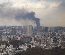 Japan's National Police Agency said on 3 April 2011, that 45,700 buildings were destroyed and 144,300 were damaged by the quake and tsunami. The damaged buildings included 29,500 structures in Miyagi Prefecture, 12,500 in Iwate Prefecture and 2,400 in Fukushima Prefecture.[225] Three hundred hospitals with 20 beds or more in Tōhoku were damaged by the disaster, with 11 being completely destroyed.[226] The earthquake and tsunami created an estimated 24–25 million tons of rubble and debris in Japan.[227][228]A fire which broke out in Tokyo after the earthquake
 All of Japan's ports were briefly shut down after the earthquake, though the ones in Tokyo and southwards soon re-opened. Fifteen ports were located in the disaster zone. The north eastern ports of Hachinohe, Sendai, Ishinomaki and Onahama were destroyed, while the Port of Chiba (which serves the hydrocarbon industry) and Japan's ninth-largest container port at Kashima were also affected, though less severely. The ports at Hitachinaka, Hitachi, Soma, Shiogama, Kesennuma, Ofunato, Kamashi and Miyako were also damaged and closed to ships.[230] All 15 ports reopened to limited ship traffic by 29 March 2011.[231] A total of 319 fishing ports, about 10% of Japan's fishing ports, were damaged in the disaster.[232] Most were restored to operating condition by 18 April 2012.[233]Ship and crane damage at Sendai port
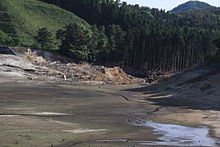 Dam failure at Fujinuma
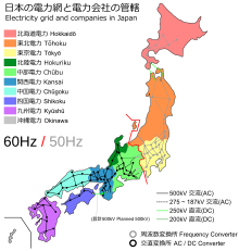 According to the Japanese trade ministry, around 4.4 million households served by Tōhoku Electric Power (TEP) in northeastern Japan were left without electricity.[244] Several nuclear and conventional power plants went offline after the earthquake, reducing TEPCO's total capacity by 21 GW.[245] Rolling blackouts began on 14 March due to power shortages caused by the earthquake.[246] The Tokyo Electric Power Company (TEPCO), which normally provides approximately 40 GW of electricity, announced that it could only provide about 30 GW. This was because 40% of the electricity used in the greater Tokyo area was supplied by reactors in the Niigata and Fukushima prefectures.[247] The reactors at the Fukushima Daiichi and Fukushima Dai-ni plants were automatically taken offline when the first earthquake occurred and sustained major damage related to the earthquake and subsequent tsunami. Rolling blackouts of approximately three hours were experienced throughout April and May while TEPCO scrambled to find a temporary power solution. The blackouts affected Tokyo, Kanagawa, Eastern Shizuoka, Yamanashi, Chiba, Ibaraki, Saitama, Tochigi, and Gunma prefectures.[248] Voluntary reduced electricity use by consumers in the Kanto area helped reduce the predicted frequency and duration of the blackouts.[249] By 21 March 2011, the number of households in the north without electricity fell to 242,927.[243]A map of Japan's electricity distribution network shows the geographic divide between 50 hertz systems and 60 hertz systems
 Tōhoku Electric Power was not able to provide the Kanto region with additional power, because TEP's power plants were also damaged in the earthquake. Kansai Electric Power Company (Kepco) cannot share electricity, because its system operates at 60 hertz, whereas TEPCO and TEP operate their systems at 50 hertz; this is due to early industrial and infrastructure development in the 1880s that left Japan without a unified national power grid.[250] Two substations, one in Shizuoka Prefecture and one in Nagano Prefecture, were able to convert between frequencies and transfer electricity from Kansai to Kanto and Tōhoku, but their capacity to do so is limited to 1 GW. With the damage to so many power plants, it may be years before a long-term solution can be found.[251]Damage to electricity transmission lines
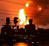 A 220,000-barrel (35,000 m3)-per-day[254] oil refinery of Cosmo Oil Company was set on fire by the quake at Ichihara, Chiba Prefecture, to the east of Tokyo.[255][256] It was extinguished after ten days, injuring six people, and destroying storage tanks.[257] Others halted production due to safety checks and power loss.[258][259] In Sendai, a 145,000-barrel (23,100 m3)-per-day refinery owned by the largest refiner in Japan, JX Nippon Oil & Energy, was also set ablaze by the quake.[254] Workers were evacuated,[260] but tsunami warnings hindered efforts to extinguish the fire until 14 March, when officials planned to do so.[254]Fire at the Cosmo Oil refinery in Ichihara
 Japan declared a state of emergency following the failure of the cooling system at the Fukushima Daiichi Nuclear Power Plant, resulting in the evacuation of nearby residents.[274][275][276] Officials from the Japanese Nuclear and Industrial Safety Agency reported that radiation levels inside the plant were up to 1,000 times normal levels,[277] and that radiation levels outside the plant were up to 8 times normal levels.[278] Later, a state of emergency was also declared at the Fukushima Daini nuclear power plant about 11 km (6.8 mi) south.[279] This brought the total number of problematic reactors to six.[280]Loose livestock roam the evacuation zone
 Japan's transport network suffered severe disruptions. Many sections of Tōhoku Expressway serving northern Japan were damaged. The expressway did not reopen to general public use until 24 March 2011.[300][301] All railway services were suspended in Tokyo, with an estimated 20,000 people stranded at major stations across the city.[302] In the hours after the earthquake, some train services were resumed.[303] Most Tokyo area train lines resumed full service by the next day—12 March.[304] Twenty thousand stranded visitors spent the night of 11–12 March inside Tokyo Disneyland.[305]A highway bridge damaged and severed
 Various train services around Japan were also canceled, with JR East suspending all services for the rest of the day.[308] Four trains on coastal lines were reported as being out of contact with operators; one, a four-car train on the Senseki Line, was found to have derailed, and its occupants were rescued shortly after 8 am the next morning.[309] Minami-Kesennuma Station on the Kesennuma Line was obliterated save for its platform;[310] 62 of 70 (31 of 35) JR East train lines suffered damage to some degree;[231] in the worst-hit areas, 23 stations on 7 lines were washed away, with damage or loss of track in 680 locations and the 30-km radius around the Fukushima Daiichi nuclear plant unable to be assessed.[311]Remains of Shinchi Station
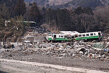 The rolling blackouts brought on by the crises at the nuclear power plants in Fukushima had a profound effect on the rail networks around Tokyo starting on 14 March. Major railways began running trains at 10–20 minute intervals, rather than the usual 3–5 minute intervals, operating some lines only at rush hour and completely shutting down others; notably, the Tōkaidō Main Line, Yokosuka Line, Sōbu Main Line and Chūō-Sōbu Line were all stopped for the day.[318] This led to near-paralysis within the capital, with long lines at train stations and many people unable to come to work or get home. Railway operators gradually increased capacity over the next few days, until running at approximately 80% capacity by 17 March and relieving the worst of the passenger congestion.Train washed away uphill from Onagawa Station
 Cellular and landline phone service suffered major disruptions in the affected area.[319] Immediately after the earthquake cellular communication was jammed across much of Japan due to a surge of network activity. On the day of the quake, American broadcaster NPR was unable to reach anyone in Sendai with working phone or Internet.[320] Internet services were largely unaffected in areas where basic infrastructure remained, despite the earthquake having damaged portions of several undersea cable systems landing in the affected regions; these systems were able to reroute around affected segments onto redundant links.[321][322] Within Japan, only a few websites were initially unreachable.[323] Several Wi-Fi hotspot providers reacted to the quake by providing free access to their networks,[323] and some American telecommunications and VoIP companies such as AT&T, Sprint, Verizon,[324] T-Mobile[325] and VoIP companies such as netTALK[326] and Vonage[327] have offered free calls to (and in some cases, from) Japan for a limited time, as did Germany's Deutsche Telekom.[328]Damaged utility pole in Ishinomaki
 754 cultural properties were damaged across nineteen prefectures, including five National Treasures (at Zuigan-ji, Ōsaki Hachiman-gū, Shiramizu Amidadō, and Seihaku-ji); 160 Important Cultural Properties (including at Sendai Tōshō-gū, the Kōdōkan, and Entsū-in, with its western decorative motifs); one hundred and forty-four Monuments of Japan (including Matsushima, Takata-matsubara, Yūbikan, and the Site of Tagajō); six Groups of Traditional Buildings; and four Important Tangible Folk Cultural Properties. Stone monuments at the UNESCO World Heritage Site: Shrines and Temples of Nikkō were toppled.[336][337][338] In Tokyo, there was damage to Koishikawa Kōrakuen, Rikugien, Hamarikyū Onshi Teien, and the walls of Edo Castle.[339] Information on the condition of collections held by museums, libraries and archives is still incomplete.[340] There was no damage to the Historic Monuments and Sites of Hiraizumi in Iwate Prefecture, and the recommendation for their inscription on the UNESCO World Heritage List in June was seized upon as a symbol of international recognition and recovery.[341]
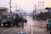 Rescue operations in the floodwaters in downtown IshinomakiMain article: Aftermath of the 2011 Tōhoku earthquake and tsunamiThe aftermath of the earthquake and tsunami included both a humanitarian crisis and a major economic impact. The tsunami resulted in over 340,000 displaced people in the Tōhoku region, and shortages of food, water, shelter, medicine and fuel for survivors. In response the Japanese government mobilized the Self-Defence Forces (under Joint Task Force – Tōhoku, led by Lieutenant General Eiji Kimizuka), while many countries sent search and rescue teams to help search for survivors. Aid organizations both in Japan and worldwide also responded, with the Japanese Red Cross reporting $1 billion in donations. The economic impact included both immediate problems, with industrial production suspended in many factories, and the longer term issue of the cost of rebuilding which has been estimated at ¥10 trillion ($122 billion). In comparison to the 1995 Great Hanshin earthquake, the East Japan earthquake brought serious damage to an extremely wide range.[342]
 Japanese students collecting funds for the victims of the 2011 Tōhoku earthquake and tsunami at the University of Pécs, Hungary
 According to Japan's foreign ministry, 116 countries and 28 international organizations offered assistance. Japan specifically requested assistance from teams from Australia, New Zealand, South Korea, and the United States.[345]Emergency vehicles staging in the ruins of Sukuiso, Japan following the tsunami
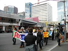 Japan's national public broadcaster, NHK, and Japan Satellite Television suspended their usual programming to provide ongoing coverage of the situation.[346] Other nationwide Japanese and international TV networks also broadcast uninterrupted coverage of the disaster. Ustream Asia broadcast live feeds of NHK, Tokyo Broadcasting System, Nippon TV, Fuji TV, TV Asahi, TV Tokyo, Tokyo MX, TV Kanagawa, and CNN on the Internet starting on 12 March 2011.[347] YokosoNews, an Internet webcast in Japan, dedicated its broadcast to the latest news gathered from Japanese news stations, translating them in real time to English.[348]Anti-nuclear protest following the disaster
 Fukushima radiation comparison to other incidents and standards, with graph of recorded radiation levels and specific accident events. (Note: Does not include all radiation readings from Fukushima Daini site)


No comments:
Post a Comment