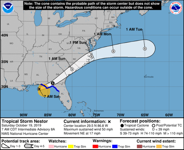
Tropical Storm Nestor bears down on the Gulf Coast
Storm surge and winds are lashing much of Florida's Gulf Coast as Tropical Storm Nestor approaches. "Strong winds, storm surge, heavy rainfall and dangerous rip currents are expected," the National Weather Service said.
But unlike Michael, a powerful storm that left thousands of people homeless and nearly wiped the Panhandle city of Mexico Beach off the map, Florida isn't bracing for a catastrophe.
"We've done very little preparation only because there's nothing really to prepare for," said Mexico City Beach Mayor Al Cathey. "We haven't seen any alarm at all."
Trending News
As of Friday evening, the state had activated its emergency operations center at its lowest level. In an area that's recently gone weeks without rain, the storm was seen more as a welcome sight.
"You have to keep it in perspective: 75 percent of our city was destroyed," Cathey said. "A little rain is welcome. Hopefully it won't be something crazy, but if that's all it is, I can deal with that. There's nothing in this system that I've seen that tells me Mexico Beach needs to be alarmed."
By early Saturday morning, the storm was centered about 85 miles south-southwest of Panama City, Florida. It had top sustained winds of 50 mph and was moving northeast at 17 mph.
Nestor was expected to move inland over the Florida Panhandle later Saturday morning, and then move across parts of the southeastern U.S. on Saturday and Sunday. It's expected to move offshore of the coast of North Carolina and into the western Atlantic Ocean by late Sunday.
The storm's expected to further weaken once it moves inland, and is forecast to become a post-tropical cyclone later Saturday. A tropical storm warning west of the Okaloosa/Walton County line in Florida has been discontinued.

No comments:
Post a Comment