begin quote from:
River Fire: Evacuations, Unhealthy Air In Monterey County As Wildfire Grows To 10,000 Acres
Filed Under:Monterey County, river fire, Salinas, Salinas News
 CBSN Bay Area Continuing Coverage00:00 - JUST NOW
 CBSN Bay Area Live (12 of 12)05:00 - 5M AGO
 CBSN Bay Area Live (11 of 12)05:00 - 10M AGO
 CBSN Bay Area Live (10 of 12)05:00 - 15M AGO
 CBSN Bay Area Live (9 of 12)05:00 - 20M AGO
 CBSN Bay Area Live (8 of 12)05:00 - 25M AGO
 CBSN Bay Area Live (7 of 12)05:00 - 30M AGO
 CBSN Bay Area Live (6 of 12)05:00 - 35M AGO
 CBSN Bay Area Live (5 of 12)05:00 - 40M AGO
 CBSN Bay Area Live (4 of 12)05:00 - 45M AGO
 CBSN Bay Area Live (3 of 12)05:00 - 50M AGO
 CBSN Bay Area Live (2 of 12)05:00 - 55M AGO
 CBSN Bay Area Live (1 of 12)05:00 - 1H AGO
MONTEREY COUNTY (CBS SF) – The River Fire in Monterey County, one of several in the region caused by last weekend’s rare lightning storm and exacerbated by the ongoing heat wave, has more than doubled in size overnight.
According to Cal Fire, the fire burning south of Salinas has burned 10,672 acres (16.6 square miles) as of Wednesday morning, up from 4,500 acres Tuesday afternoon. The fire is 7 percent contained.
ADVERTISING
Six structures have been destroyed and two others have been damaged. Meanwhile, 1,560 structures remain threatened. At least four firefighters have suffered minor injuries.
The agency said in its Wednesday morning update that mountainous, steep terrain has been a challenge, along with the absence of a marine layer due to the ongoing heat wave in the region. Monterey County remains under an Excessive Heat Warning through Wednesday night, according to the National Weather Service.
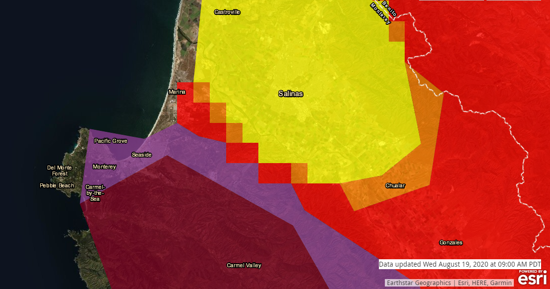
Poor air quality is also an issue. According to AirNow.gov data, particulate matter pollution has reached very unhealthy and hazardous levels on the Monterey Peninsula as of 9 a.m., including the communities of Monterey, Seaside, Carmel and the Carmel Valley.
People across Monterey County reported widespread smoke and ash Wednesday morning.
Numerous evacuation orders and evacuation warnings remain in effect. Additional evacuation orders were announced around 10 a.m. Wednesday.
More than 820 personnel have been assigned to the fire, including crews from the Bay Area.
Full containment of the River Fire is not expected until at least August 30th.
Evacuation Orders:
- Pine Canyon Rd, Parker Rd, Laurel Ln, and Trimble Hill Ln.
- West of River Rd to Parker Rd, South to Limekiln Rd to include Limekiln Rd.
- Limekiln Road South to Gonzales River Road.
Evacuation Advisory:
- South of River Rd from Tara Dr. to Pine Canyon Rd. to include all roads off of: Las Palmas Pkwy, Ranchito Dr, Indian Springs Rd, Berry Dr, Enos Dr, Redding Dr, and Belmont Circle.
- Indian Canyon, Mt. Toro Access Rd and San Benancio Rd from Troy Ln to Corral de Tierra, including Corral del Cielo Rd, Lucie Ln, and Covie Ln.
- Southwest of Parker Rd, Northwest of Corral del Cielo Rd and Rana Creek, southeast of the intersection of Chualar River Rd and River Rd, northwest of Limekiln Rd/Creek.
- Harper Canyon Area, all areas north of San Benancio Rd, west of Troy Ln, southeast of Harper Canyon Rd, to include Harper Canyon Rd, Weather Rock Way, and Rimrock Canyon Rd.
Evacuation center:
- Monterey County has opened an evacuation center at Toro Park School, 22500 Portola Drive, Salinas, Ca.
- Residents who need emergency housing or have lost homes, may reach out to the American Red Cross 24 hour disaster dispatch helpline: 1-866-272-2237. To assist with evacuees being effected please visit the link
Road closures:
Pine Canyon at Mesa Road
River Road at Parker Road
Animal evacuation centers: Please call SPCA Monterey County at 831-264-5455


No comments:
Post a Comment