Willamette Falls
From Wikipedia, the free encyclopedia
Human history
Drawing of the falls prior to development
Native American legends taught that the falls were placed there by a
great god so that their people would have fish to eat all winter.
[2] Many local tribes built villages in the area because of the abundance of
salmon that could only pass the falls at certain water levels. Native Americans still harvest
Pacific Lamprey
at the falls each year in the early summer. Willamette Falls is a
traditional fishing site for the Warm Springs Indians as well as other
tribes.
It was first discovered by European fur traders in 1810.
John McLoughlin established a land claim at the falls in the name of the
Hudson's Bay Company in 1829.
[3] Oregon City was established in 1842 near the east end of the falls. The town of
Linn City
was founded on the western shore one year later in 1843. The two towns
competed economically, vying for the lucrative steamboat traffic and the
trade it generated. With the falls representing the end of the line for
boat traffic, river boat captains were forced to choose a side of the
river on which they would dock to unload their passengers and goods;
some of which would continue their upriver journey on winding portage
toll roads. Competition between the towns was fierce until the
Great Flood of 1862. Oregon City was inundated and badly damaged, but the unluckier Linn City was obliterated.
Navigating past the falls was not possible until the completion of the
Willamette Falls Locks
in 1873. During construction of the locks, channels were blasted from
the very rocks that formerly supported the town of Linn City. Along with
the locks, the modern city of
West Linn
sits on a portion of the former town site. The locks were sold by the
Willamette Falls Canal and Locks Company to the United States
Army Corps of Engineers in 1915.
Modern history
The falls in 2009 from the east with West Linn in the background
The Willamette Falls Electric Company (later renamed
Portland General Electric)
was formed in 1888 to build a hydro-electric generation facility at the
falls. Four turbine driven dynamos were built on the east end of the
falls. A 14-mile (23-kilometre) long transmission line to
Portland was built, becoming 1889 the United States' first long distance
transmission of electrical energy.
[4][5] In 1895
Portland General Electric
built a second generation station on the west side of the falls. The
newer plant, Station B, is still in operation with a capacity of 14,000
kilowatts. The old plant is currently part of the Blue Heron Paper
Company.
The falls have been home to several paper mills beginning with the
Oregon City Paper Manufacturing Co. in 1866. The Willamette Pulp and
Paper Co. opened on the West Linn side during 1889. The ownership of the
mills has changed several times. The last two remaining mills in 2011
were owned by the West Linn Paper Company and the Blue Heron Paper
Company, but the latter closed its mill in February 2011. The Blue Heron
site has subsequently been auctioned off, for redevelopment. The
milling facilities were sold to a Canadian investment firm, NRI Global,
Inc., which has begun work removing the old machinery and cleaning the
grounds of contamination.
[6] An agreement for the sale of the site itself was announced in June 2013,
[7] but later fell apart.
[8] In May 2014, another developer, George Heidgerken, purchased the property.
[9] Plans for redevelopment of the site were being developed in fall 2014.
[10]
The industrialization of the area led to diminishing
salmon and
steelhead runs, prompting the construction of a
fish ladder in 1882. A new
fish ladder, built in 1971, is currently operated by the
Oregon Department of Fish and Wildlife. The estimated spring chinook
salmon run for 2007 is 52,000.
[11]
The industrialization has also precluded public access to the base of
the waterfall for well over a century, but as of 2017 a process to
redevelop the Blue Heron Paper Mill site and provide public access to
the area, including a river walk, is underway.
Details
The falls is a
horseshoe shaped block waterfall caused by a
basalt
shelf in the river floor. The 40 ft (12 m) high and 1500 ft (457 m)
wide falls occur 26 river miles (42 km) upstream from the Willamette's
confluence with the
Columbia River.
Operated by the U.S. Army Corps of Engineers, the lock is a four lock
canal and was the oldest continuous operating, multiple lift navigation
canal in the United States.
The public can view the falls from viewpoints on the bluffs of
Oregon City, from a signed viewpoint along
Highway 99E, from the
Oregon City Bridge, from a viewpoint on northbound
I-205, or from boats in the river.
-
-
-
View is downriver facing northeast. The locks are at far left.
-
An aerial view of the Willamette Falls with the river near flood stage, taken on January 22, 2006
-
Panorama of the paper mill on October 23, 2010
-
Panorama of the Willamette Falls on March, 2012
References

 Drawing of the falls prior to development
 Native American legends taught that the falls were placed there by a great god so that their people would have fish to eat all winter.[2] Many local tribes built villages in the area because of the abundance of salmon that could only pass the falls at certain water levels. Native Americans still harvest Pacific Lamprey at the falls each year in the early summer. Willamette Falls is a traditional fishing site for the Warm Springs Indians as well as other tribes.Willamette Falls boat basin in 1867, photograph by Carleton Watkins
 The Willamette Falls Electric Company (later renamed Portland General Electric) was formed in 1888 to build a hydro-electric generation facility at the falls. Four turbine driven dynamos were built on the east end of the falls. A 14-mile (23-kilometre) long transmission line to Portland was built, becoming 1889 the United States' first long distance transmission of electrical energy.[4][5] In 1895 Portland General Electric built a second generation station on the west side of the falls. The newer plant, Station B, is still in operation with a capacity of 14,000 kilowatts. The old plant is currently part of the Blue Heron Paper Company.The falls in 2009 from the east with West Linn in the background
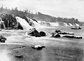 The falls in 1918
 The falls after the December 2006 Pacific Northwest storms swelled the Willamette River and part of the paper mill
 View is downriver facing northeast. The locks are at far left.
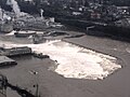 An aerial view of the Willamette Falls with the river near flood stage, taken on January 22, 2006
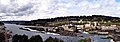 Panorama of the paper mill on October 23, 2010
 Panorama of the Willamette Falls on March, 2012
 | Weather Underground")


No comments:
Post a Comment