A shattered tectonic plate underpins the Tibetan Plateau — explaining the area’s weird earthquakes
A new geophysical model shines some light on the Tibetan Plateau’s unique geology.
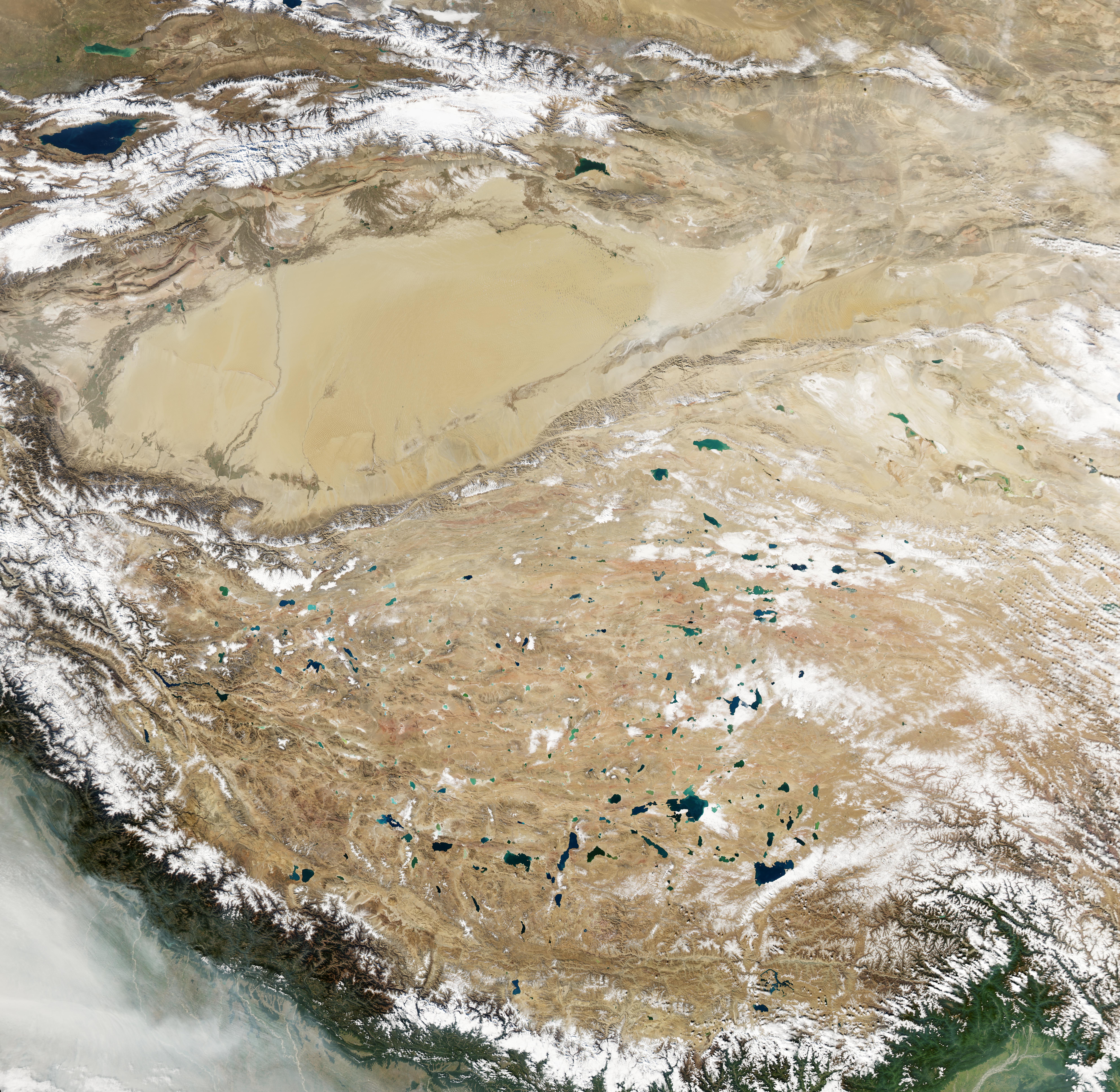
Natural-color image of the Tibetan Plateau.
Image credits NASA Earth Observatory.
Image credits NASA Earth Observatory.
Some 50 million years ago, India was a huge hit in Asia — quite literally, as the peninsula smashed into the continent after breaking up with Gondwana, creating the Himalayas of today. We don’t know very much about the specifics of this collision, as the Tibetan Plateau — an area at the epicenter of this collision — is quite inhospitable and hard to reach, for earth scientists and laymen alike.
New research, led by scientists from the University of Illinois at Urbana-Champaign, comes to shed more light on the event. Not only do the findings help patch our understanding of the area’s geology. The results also help explain the highly-peculiar — and very violent — seismic activity in this area.
Shaking things up
“The continental collision between the Indian and Asian tectonic plates shaped the landscape of East Asia, producing some of the deadliest earthquakes in the world,” said Xiaodong Song, a geology professor at the University of Illinois and co-author of the new study.“However, the vast, high plateau is largely inaccessible to geological and geophysical studies.”
Song and his team drew on high-resolution seismic (earthquake) data to generate the clearest model of the Tibetan Plateau’s geology to date. They pooled together geophysical data from various studies and other sources, and collated them to generate seismic tomography images of Tibet — think of them as ultrasound imaging for geology — that peer down to about 160 kilometers under the surface.
Their work reveals that the upper mantle layer of the Indian tectonic plate is broken into four distinct pieces that push under the Eurasian plate. Each of these four fragments lies at a different distance from the origin of the tear and moves at a different angle relative to the surface than its peers. The new data match well with recorded earthquake activity, geological, and geochemical observations in the area, the team writes, which helps improve confidence in the results.
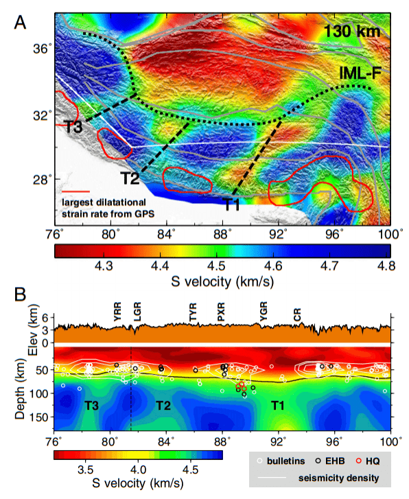
Seismic wave velocity images of the Tibetan Plateau in image a (map view) and image b (cross-section view). In image b, T1, T2 and T3 mark mantle tears, the circles indicate earthquakes deeper than 40 kilometers and the white contours show earthquake density.
Image credits Jiangtao Lia, Xiaodong Songa, (2018), PNAS.
Image credits Jiangtao Lia, Xiaodong Songa, (2018), PNAS.
“The presence of these tears helps give a unified explanation as to why mantle-deep earthquakes occur in some parts of southern and central Tibet and not others,” Song said.
While the Indian plate was definitely shredded after the impact, the bodies of intact crustbetween the tears (the four fingers themselves) are still strong enough to accumulate strain — and such strain, when released, is what causes earthquakes. At the same time, heat upwelling from the deeper mantle can pass through the torn areas more readily. Areas of crust directly above the tears become more ductile and less susceptible to earthquakes as they warm.
This last tidbit of information helps explain the “unusual locations” of some of the earthquakes in the plateaus’ southern reaches, according to co-author Jiangtao Li, who adds that “there is a striking correlation with the location of the earthquakes and the orientation of the fragmented Indian upper mantle”.
The model also helps us get a better idea of the local geology as a whole, explaining some of the area’s more peculiar surface deformation patterns, such as a series of unusual north-south rifts along the plateau, for example. Such deformation patterns, together with the location of most earthquakes in the area, further suggest that the crust and upper mantle are strongly coupled in southern Tibet — i.e. surface rocks are very well ‘glued’ to deeper formations.
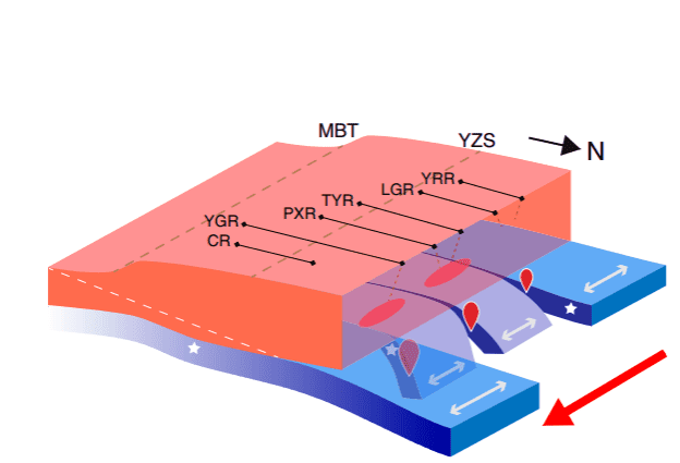
Idealized cartoon illustration of the tearing of the Indian plate and coupling between the crust (orange) and the mantle lithosphere (blue) in south-central Tibet. The thickness of the crust and mantle lithosphere is not to scale. The white dashed line marks the possible boundary between the underthrusting Indian crust and the overriding Himalayan orogenic prism and Tibetan crust.
Image credits Jiangtao Lia, Xiaodong Songa, (2018), PNAS.
Image credits Jiangtao Lia, Xiaodong Songa, (2018), PNAS.
Overall, the findings offer a clearer picture of the state of the crust and upper mantle in the Tibetan Plateau. The findings will also help us better assess areas that are at risk from earthquakes, the team adds, with the potential to safeguard lives and property from their devastating effects.
The paper “Tearing of Indian mantle lithosphere from high-resolution seismic images and its implications for lithosphere coupling in southern Tibet” has been published in the journal Proceedings of the National Academy of Sciences.
How much money can a solar roof save you in California?
Profit from your roof space: find local deals on solar in your area, eliminate your power bill.

Enjoyed this article? Join 40,000+ subscribers to the ZME Science newsletter. Subscribe now!
end quote from:https://www.zmescience.com/science/tibet-plateau-tectonic-fingers-95973523/
No comments:
Post a Comment