
From the perspective of being in Mt.
begin quote from:
Lava Fire continues to spread near Mt. Shasta
The nearby Tennant Fire has burned over 9,000 acres
Updated at 7:22 a.m. PDT July 1, 2021
Lava Fire
The Lava Fire was most active Wednesday on the east side, north of Mt. Shasta, where beginning at 4:30 p.m. it spread to the east for more than a mile. It chewed up another 2,000 acres to bring the size up to 19,680 acres.
Firefighters conducted burning operations Tuesday night on the west side, south of Highway 97. On Wednesday they made progress on the southwest side with the heavy use of hand crews, dozers, helicopters, and air tankers.
(To see all articles on Wildfire Today about the Lava Fire, including the most current, click HERE.)
Resources assigned to the fire Wednesday evening included 26 hand crews, 86 fire engines, and 13 helicopters for a total of 1,273 personnel. Air tankers are used as needed and available, but are not assigned to any one fire.
No information has been released about the number of structures destroyed.
Evacuation orders are in effect; details for the Lava and Tennant Fires are at https://arcg.is/1CrfH40.
Tennant Fire
The Tennant Fire, 15 miles northeast of the Lava Fire, was active on both the east and west sides on Wednesday, spreading for about 0.4 of a mile on both sides. It has burned on both sides of Highway 97 and as of 11:30 p.m. on Wednesday had blackened 9,439 acres, an increase of about 1,300 acres over 24 hours.
The Incident Management Team reported that five structures have been destroyed.
Wednesday evening there were 278 personnel assigned to the Tenant Fire, including 7 hand crews, 14 engines, 5 dozers, 13 helicopters, and 50 overhead personnel. Air tankers are used as needed, but are not assigned to any one fire.
Weather
The weather forecast for Thursday calls for sunny skies, almost no chance of rain, 91 degrees, 15 percent relative humidity, and in the mid-afternoon 15 mph winds out of the south gusting to 23 mph. This could, again, lead to active fire behavior after 1 p.m. The outlook for Friday is about the same.

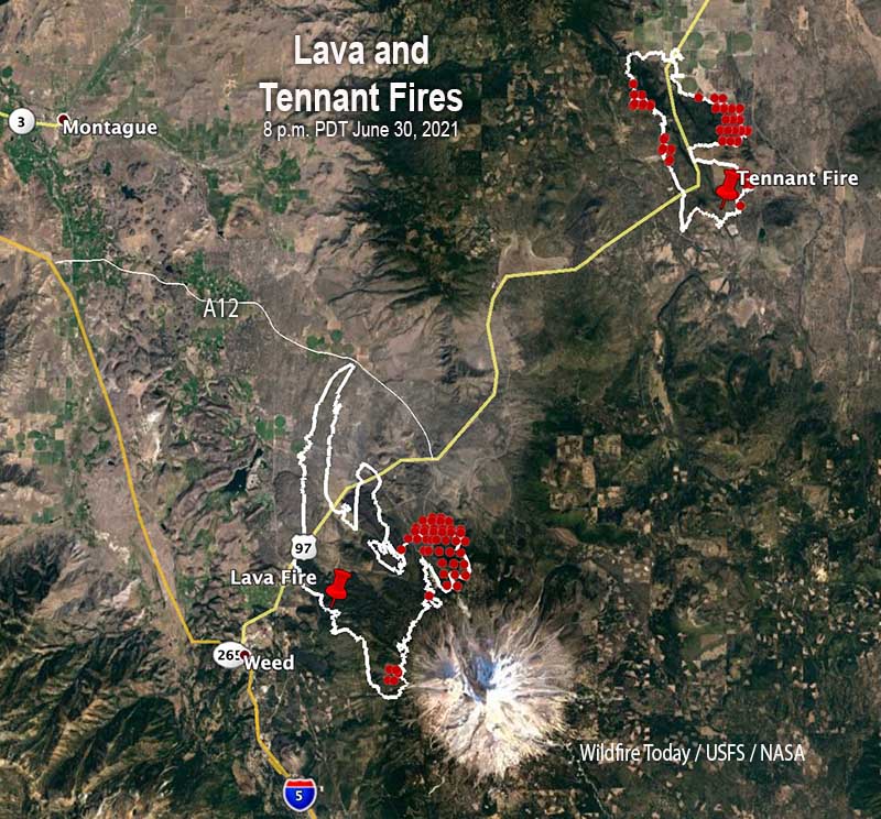
7:10 a.m. PDT June 30, 2021

Lava Fire
The Lava Fire about two miles east of Weed, California was very active late in the afternoon Tuesday, putting up a large convection column of smoke topped by a pyrocumulus cloud. There was some growth to the north into Juniper Flats near Highway A12, but the majority of the movement was to the south and east in timber stands on the west and north slopes of Mt. Shasta. Spotting from torching trees created spot fires up to 0.75 mile out.
It was mapped Tuesday night at 17,591 acres.
The fire is burning through brush and timber which is interrupted by numerous patches of lava rock left over from many volcanic eruptions over the last 593,000 years. The fire is driven by very dry vegetation, spot fires, and occasional gusty winds.
(To see all articles on Wildfire Today about the Lava Fire, including the most current, click HERE.)
The U.S. Forest Service fire organization has entered into unified command, with CAL FIRE assuming the north branch containing the most community protection.

Approximately 3,200 residents have been evacuated in the community of Lake Shastina.
Crews initially attacked the fire when it was small, then left
The San Francisco Chronicle reported that in a town hall meeting Monday night the Forest Fire Management Officer (FMO) of the Shasta-Trinity National Forest said fire crews initially attacked the Lava Fire Friday afternoon when it was 1/4 acre.
Shasta-Trinity National Forest spokesperson Adrienne Freeman said the crews, thinking it was safe, left at 4 p.m. with plans to watch it from afar and return Saturday morning. However an hour later it flared up and spread rapidly.
“I apologize for that getting out”, the FMO said in the town hall meeting. “I’ll take the heat for that … I will own that … They got in with an initial attack and they got beat. It happens sometimes and is not the intended outcome, not what we want. We’re all disappointed that this happened, but it happened.”
Tennant Fire
The Tennant Fire first reported at 4 p.m. June 28 is 16 miles northeast of the Lava Fire on both sides of Highway 97 near Tennant Road. It is mostly on land protected by the Forest Service but is also on private property protected by CAL FIRE. The Forest Service reported Wednesday morning that it was mapped at 8,159 acres. It was very active Tuesday.
California Interagency Incident Management Team 15 will assume command of the Tennant Fire Wednesday.
Evacuation orders are in effect; details for both fires are at https://arcg.is/1CrfH40.

Weather
The weather forecast for Wednesday calls for 98 degrees, relative humidity in the low teens, and in mid-afternoon 14 mph winds out of the south gusting to 21 mph. This could result in fire behavior similar to what was seen Tuesday. A red flag warning is in effect Wednesday for Southern Oregon 17 miles north of the Tennant Fire.
The outlook for Thursday is about the same, but the wind will be from variable directions at 2 to 7 mph.

No comments:
Post a Comment