We left about noon today for Mt. Shasta. We were able to rent a friends Guest House for the rest of the month which is good. The colder weather has left Oregon And Northern California even though it is about 35 Degrees Fahrenheit right now as I write this around midnight Tuesday night. We drove up today Tuesday. The weather driving north from the SF Bay area was surprisingly warm too with I think Almond trees the whole way were in bloom which seems pretty early for that. But, after all it's been a warm and mostly droughty Winter season so far except for one really intense Atmospheric river that flooded homes with mud and pinned one lady in her house and cut Highway 1 around Big Sur for maybe 6 months or more it looks like.
Anyway, driving north there were temperatures as high as 79 degrees which seemed pretty hot for February of ANY year this far north. But, that's Global Warming for you. So, whether you get warmer than normal temperatures this year like much of California or The North Pole coming to you From Texas to Montana and points east, Global Climate Change is changing all our live irrevocably along with the pandemic (which is also a part of Global Climate change and the 6th Great Extinction of species on earth.
Where we live on the coast it was supposed to be 69 degrees today too and yesterday it was 68 which is pretty good for the coast this time of year too. High tomorrow here in Mt. Shasta is 47 degrees which is not bad for 3700 feet up in the mountains of northern California.
Highway 1 through Big Sur will be repaired. How long that takes is unclear


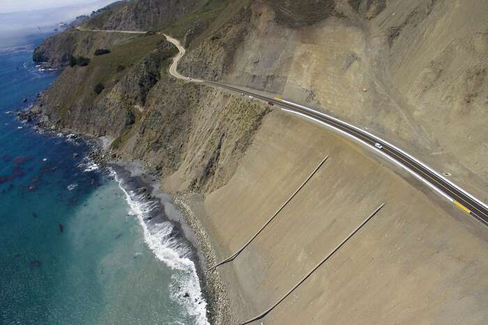
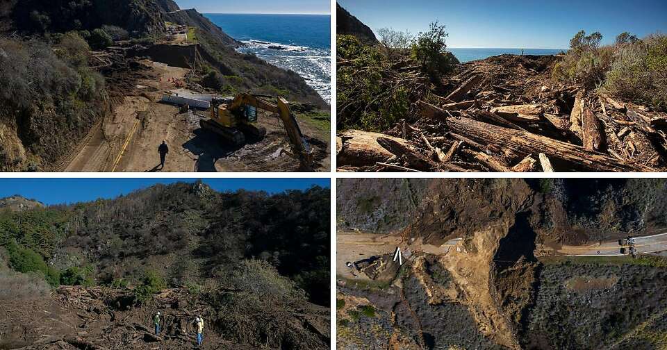
BIG SUR — Ryan Turner stood high on the ocean bluff, his hard hat and construction vest firmly fastened, and eyed a 150-foot gap in Highway 1 where the road had tumbled into the sea.
As a geotechnical engineer with the California Department of Transportation, Turner, 38, must help devise a fix for the latest Big Sur washout.
The road collapse, which occurred during last month’s powerful storm, has shut down a segment of the famously rugged highway about 50 miles south of Monterey. It not only severed the local community’s only thoroughfare but left Big Sur fans everywhere awed by photos of the wreckage and wondering how — and how soon — they might see a repair.
As everyone knows, putting things back together in Big Sur is not easy. The place was never meant to stay put. And the job is only getting tougher. While the region has been in motion ever since tectonic forces lifted the Santa Lucia Mountains to their towering heights above the Pacific millions of years ago, climate change is likely accelerating the wear and tear.
“Yeah, it’s a challenge,” said Turner, who was on his seventh straight day of work surveying the damage at Rat Creek late last week. “The Big Sur coast, obviously, is very active geologically.”
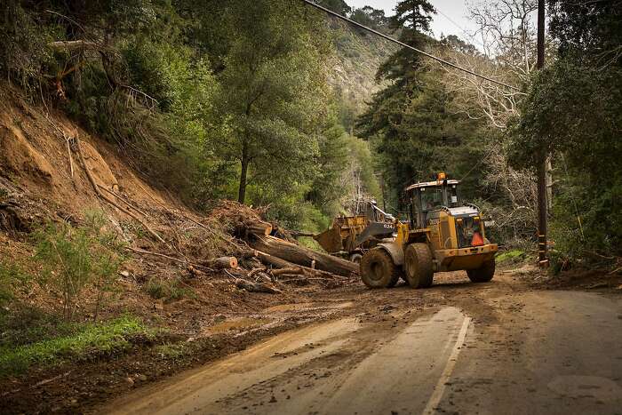
The past five years have exposed Mother Nature’s mounting fury. In 2016, one of the Central Coast’s biggest wildfires, the drought-fueled Soberanes Fire, ravaged 132,000 acres of Big Sur, leaving vast patches of unstable trees and hillsides. Many parks and roads are still shut down because of the hazards.
The following year, one of California’s wettest winters thrashed the area. The near-record rain culminated in a giant landslide at Mud Creek, near the community of Gorda, which buried Highway 1 and closed the area for 14 months while the road was rebuilt.
At the recent Rat Creek washout, water and flames combined to wreak havoc. The Dolan Fire last summer destabilized the southern end of Big Sur, making it ripe to slide when the January storm hit. With 16 inches of rain in some spots, runoff carried weakened trees and shaky slopes down the mountain, ultimately pouring across the road near mile marker 30 and breaking the highway apart.
At least 50 smaller slides occurred along Highway 1 in the burn area. Most have been cleared, but several are still being repaired.
“The two variables that influence all this are wildfire intensity and rainfall intensity,” said Jon Warrick, a research geologist for the U.S. Geological Survey who studies Big Sur’s shifting topography. “If climate change influences wildfire occurrence and intensity, that can increase the likelihood of debris flows. And if climate change influences rainfall intensity, it can also increase debris activity.”
Turner and his colleagues at Caltrans remain undeterred by the growing challenges.
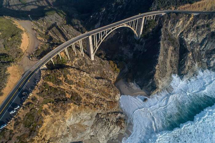
They are committed to keeping Big Sur’s roughly 90 miles of Highway 1 open, even though the 1930s-era road was designed as a seasonal route, like the storm-prone passes in the Sierra that are closed in the winter. Their calculus stems from the road’s high value to the economy.
“This highway has interest worldwide. People are traveling from all over the world to see this,” said Jim Shivers, a spokesman for Caltrans. “Abandoning the highway or walking away from it (seasonally) just never enters the discussion.”
Caltrans has spent about $200 million to repair damage to Highway 1 in Big Sur over the past decade, according to agency records. Officials say the benefits of having a functional artery far outweigh the maintenance costs.
Big Sur resident Dream Mullick, 49, was strolling down the closed section of road last week under sunny skies. She wanted to peek at the mess at Rat Creek.
Like many in the region, Mullick moved to Big Sur to escape city life. The Southern California transplant was seduced by the area’s wild beauty and a bohemian vibe, which has dimmed only slightly with the influx of tech money and tourists. The road — without cars — had Mullick imagining a quieter era.
“I’m told it’s like Big Sur in the ’70s,” she said. “But actually, there’s all the Cats (construction equipment) going ‘vroom, vroom.’”
Those living south of the slide face real inconvenience. Most of the region’s limited services, including the grange or community center, health clinic and general stores, are in the community of Big Sur north of the slide. Additional services are another 30 miles north in Monterey.
That means Surge Withrow, 48, who lives with his family near Lucia, has to drive a circuitous three-hour route inland to get to doctor’s appointments on the Monterey Peninsula for his special-needs son. If the road were open, it would be an hour’s drive.
“We’re in lockdown,” Withrow said. “We have only one way in or out.”
A volunteer group that has been providing food to needy residents during the coronavirus pandemic has made a point of continuing its services, even if it means making the cumbersome trip from north of the slide to the south.
“We’re trying to figure out who’s on this side and who’s on that side,” said Helen Handshy, 41, who lives on Pfeiffer Ridge and started the Big Share organization with her partner, Joseph Bradford, in March.
On Friday, Handshy packed a truck and van with supplies, including locally sourced organic peppers, collard greens, tangerines and frozen turkeys, and convoyed to 25 families in the Lucia area.
Big Sur’s tourist-dependent businesses also face hurdles. Most restaurants, spas, art galleries and lodges, which are located north of the slide, will see fewer people from the south, reducing visitation by as much as a third, the Big Sur Chamber of Commerce estimates. The region sees 5 million visitors or more a year, when conditions allow it.
“It’s a particular challenge because we’re already restricted because of COVID,” said chamber President Kirk Gafill, who operates Nepenthe, a popular restaurant and gift shop perched on a cliff along Highway 1. “To add anything else that reduces demand is adding insult to injury.”
Visitor spending can amount to a couple of billion dollars annually, according to the Monterey County Convention and Visitors Bureau, a hearty sum for the local economy.
Whether entrepreneurs can survive the closure, Gafill said, will depend largely on whether the road reopens for at least part of the summer high season.
Caltrans’ Turner said it’s too early to know how long Highway 1 at Rat Creek will remain closed.
The engineer, who has dissected the highway failure like a football coach poring over plays after a big game, expects it will be weeks before he and his colleagues develop a repair plan.
The debacle began at least a half mile up the drainage, Turner said, pointing to a ridge above the road that was scorched by last year’s Dolan Fire. There, a combination of burnt vegetation, which was no longer able to secure the hillside, along with slick “hydrophobic” soils caused by the fire allowed the recent rain to shear chunks of dirt, rocks and trees.
“When the debris flow originated from the canyon, it almost immediately plugged the culvert” beneath the road, Turner explained.
A “lake” of water and debris then pooled on the inland side of the highway, he said, and eventually overtopped the road and tore it down.
Much of the debris remained in the canyon late last week. It included boulders and downed redwood trees, some 5 feet in diameter. Trees that were still standing were caked with mud, sometimes 25 feet up their trunks, revealing the stunning depth of the water.
The U.S. Geological Survey had recently assessed the area of the Dolan Fire for the potential of sliding. According to the agency’s hazard map, Rat Creek had a 60% to 80% probability of experiencing a debris flow with heavy rain, defined as 1 inch in an hour.
“It’s no surprise to us or anyone on the coast that these things happen,” said Jason Kean, a USGS research hydrologist who helped with the hazard mapping. “The Big Sur coast is well known for landslides with or without fire. Fire just makes them easier to happen.”
More than 1,500 active or dormant slides exist along the Highway 1 corridor in Big Sur, according to a 2005 assessment by the California Department of Conservation.
At the Rat Creek slide, the ocean below was still chocolaty with debris a week after the storm. But the crashing waves and sandy cliffs were framed by a cloudless sky that gave little clue of the recent turbulence.
Turner said he and his co-workers have narrowed the possible fixes for the highway to two. They can build a bridge across the new, storm-carved canyon or they can replace the missing soil and rock, reinsert a larger culvert and build the road over the top. There’s no estimated cost or timeline for either option.
“Given what happened,” Turner said, “we just don’t want to have to come back again and repeat this.”
Kurtis Alexander is a San Francisco Chronicle staff writer. Email: kalexander@sfchronicle.com Twitter: @kurtisalexander
No comments:
Post a Comment