https://www.google.com/maps/@38.6474825,-120.8251307,9z/data=!4m3!15m2!1m1!1s%2Fg%2F11rwptxy0p
And here are the map coordinates for the Dixie Fire:
begin quote from:
https://www.mercurynews.com/2021/08/16/map-dixie-fire-perimeter-and-evacuation-zones/
Map: Dixie Fire perimeter and evacuation zones
Support local journalism
The mandatory evacuation area for the Dixie Fire has been extended to the edge of Susanville and along Highway 395.
The Tuesday morning report from the Forest Service fire managers put Dixie’s area at 604,511 acres (945 square miles), up 25,000 acres from the previous evening. Containment remained at 31%.
The latest perimeter map shows an eastern arm of the fire within 7 miles of Susanville. On its west side, flames have reached Highway 36 between Chester and Westwood and at a spot fire just east of Mineral.
Firefighters are expecting the fire to be particularly active at its east edge Tuesday; strong southwest winds are forecast, and a red-flag warning is in effect through 11 p.m.


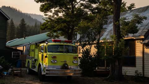


The California Department of Forestry and Fire Protection said that 1,173 structures have been destroyed by the fire; of those, 633 are residences. Click here for a searchable map showing the status of buildings in the fire zone.
The evacuation zone of about 1,800 square miles in Plumas, Tehama, Shasta and Lassen counties is shown by the orange border on the map above, and in more detail — including warning areas — on the counties’ official map at the bottom of this article.
Dixie, now California’s second-largest wildfire on record, was reported on July 13 along Highway 70 just north of the scar of the 2018 Camp Fire. Its cause is under investigation.
No comments:
Post a Comment