Top stories


Ellicott City flood devastation: Stunning videos, photos from flooding
https://www.usatoday.com/story/news/nation/2018/05/29/...flood.../650489002/
1 day ago - ELLICOTT CITY, Md.Eastern flooding continues as Plains see more severe storms - ABC ...
https://abcnews.go.com/US/eastern-flooding-continues-plains-severe-storms/story?id...
5 hours ago - Evacuations are in effect this morning in McDowell County, North Carolina, which is experiencing its worst flash flood emergency since ...begin quote from:
Ellicott City, Maryland, flooding: Climate change is coming as rain.
https://slate.com/.../ellicott-city-maryland-flooding-climate-change-is-coming-as-rain....
22 hours ago - Two years ago, Ellicott City, Maryland, was hit by a debilitating flash flood that turned the town's historic Main Street into a raging muddy river.
THE SLATEST
The Maryland Flooding Is a Warning
Climate change is hitting America as rain, and we’re making it worse.
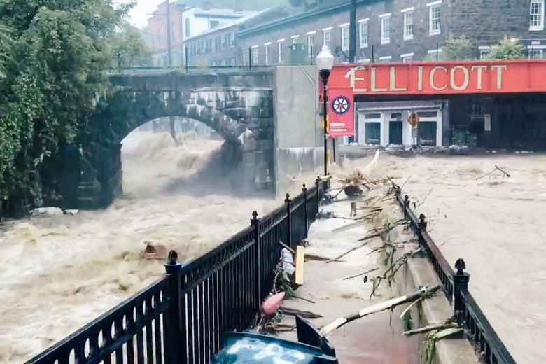
Flooding is seen in Ellicott City, Maryland, on Sunday in this still image from video from social media.
Todd Marks/Reuters
Two years ago, Ellicott City, Maryland, was hit by a debilitating flash flood that turned the town’s historic Main Street into a raging muddy river. Scientists said the July 2016 rainstorm was a once-in-a-thousand-year event.
But on Sunday it happened again: 7 to 9 inches of rain fell in the area, 10 miles west of Baltimore, and another torrent swept cars and trees through town. More than 1,000 911 calls were recorded on Sunday afternoon, more than 300 residents were evacuated, and a National Guard sergeant died trying to rescue someone.
“This is worse,” said Howard County executive Allan Kittleman, compared with the 2016 storm, which caused tens of millions in damages and lost business.
Ellicott City isn’t some postwar boomtown built inside a reservoir or a vacation community playing chicken with the ocean waves. It’s a 250-year-old river town, and like many river towns, it’s known flooding, chiefly from the rising waters of the Patapsco, the river at the foot of town that drains into Baltimore Harbor.
But these past two storms—as well as September 2011 flooding from Tropical Storm Lee—have worked differently. Instead of the water rising from the river at the base of the town, it’s come roaring in down two tiny tributaries, the Tiber and the Hudson, which merge just before entering the Patapsco. According to a Baltimore Sun investigation, prior to 2011, it had been 60 years since runoff on the Tiber stream produced a flash flood. Now it has happened three times in seven years.
It’s a reminder that heavy rain, rather than rising seas, may be the earliest severe consequence of climate change. We’ve prepared for it in the worst way possible.
Between 1958 and 2012, according to the 2014 National Climate Assessment, the amount of rain falling in “very heavy events”—those at the top 1 percent of all rainstorms—has risen by 27 percent in the Southeast, 37 percent in the Midwest, and a whopping 71 percent in the Northeast. The most extreme downpours are getting more extreme. (Coincidentally, this weekend also saw just the ninth classified storm to make landfall before hurricane season since 1851 when Alberto hit the Florida panhandle, and a virtually unprecedented Category 3 Tropical Cyclone in Oman.)
But climate change isn’t the only reason these disasters aren’t quite natural. Unchecked sprawl has built a concrete funnel around Ellicott City. “All this natural vegetation that would act as sponges is being replaced by concrete and impervious surfaces,” explains Stephen Strader, a professor at Villanova who studies environmental risk. Nearly one-third of the Tiber–Hudson “sub-watershed” was covered by hard surfaces 10 years ago, according to the Chesapeake Bay Trust, and sprawling development hasn’t stopped since. The result, Strader says, is a flash-flood scenario more reminiscent of the American West, where naturally impervious land creates the conditions for sudden, dramatic floods that, over time, have carved out slot canyons.
The sprawling, asphalt-based model of American postwar planning has permanently altered the way the landscape drains water. The Federal Emergency Management Agency bases flood maps on elevations and channels but ignores the impact of the built environment. Doing so, Texas A&M professor Samuel Brody told me a few months ago, is a critical mistake. “The bigger issue is that we’ve [completely] misconceptualized what flood risk is,” he argues. “We’re not baking in the human element that’s driving some of these flood problems.” How urban floods form and move owes as much to parking lots, soundwalls, highways, railroad tracks, and sewer backups as to natural topography.
Going back to 1972, about half of all flood insurance claims in Harris County—home of Houston—have been made outside the FEMA flood plain, according to Brody’s research, and the rate was even higher after Hurricane Harvey dumped dozens of inches of rain there last summer. That’s in part due to the increased severity of modern storms, but also to the category error by which FEMA plans without accounting for the postwar landscape. In Cook County, Illinois, more than $773 million was paid out for urban flooding damage between 2007 and 2011.
There was no correlation between ZIP codes with FEMA flood plains and those with damage payouts.
There was no correlation between ZIP codes with FEMA flood plains and those with damage payouts.
To further complicate matters, new development can change flooding patterns miles away. In the 1960s developers built Meyerland, one of the Houston neighborhoods that flooded for the third year running during Hurricane Harvey last year. At the time, only a sliver of it was in the flood plain along the bayou. Since then, the booming exurbs of Harris County have thrust more and more of the neighborhood into flood territory, leading to hundreds of millions in federal insurance payouts. Three-quarters of the absorbent Katy Prairie grassland has been paved over, sending water rushing downstream through obsolete infrastructure. “You get flood plains moving into people, not just the other way around,” says Brody.
That is what seems to have happened in Ellicott City, too: an old downtown in a new flood plain.
No comments:
Post a Comment