00:00
00:28
NATION-NOW
40 million in West face scorching heat; 30 million under flood watch in East
20% of Americans at risk of extreme heat or floods
Author: John Bacon and Doyle Rice, USA TODAY
Published: 8:41 AM EDT July 24, 2018
Updated: 5:29 PM EDT July 24, 2018

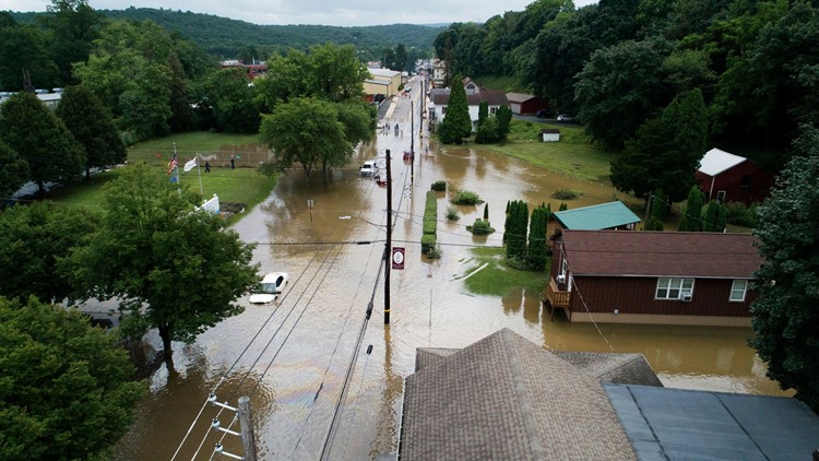
Floodwater covers North Tulpehocken Street in Pine Grove, Pa., Monday, July 23, 2018, after rain passed through the area.
David McKeown, AP
Heavy rains drenched much of the Northeast for a fourth consecutive day Tuesday, swelling rivers and flooding roads, while the western U.S. endured scorching temperatures and heat warnings.
About 40 million people from Washington state to Arizona were under an excessive heat warning or advisory Tuesday afternoon, the National Weather Service said. About 32 million people were under a flood watch, most of them in the East.
Phoenix hit 113 degrees by early afternoon Tuesday, with Wednesday's forecast also calling for a high of 113. Monday's high was a record 115, the weather service said.
Maricopa County public health officials said people should take the heat warnings seriously, noting 155 people died in the Phoenix area last year from heat exhaustion and heatstroke.
Death Valley will see highs above 120 the next couple of days, with nighttime temperatures dropping to only about 100.
Southern California also was locked in a pattern of triple-digit temperatures, and people were urged to ease off the air conditioner and other appliances during peak power usage from 5-9 p.m. Wednesday.
In the normally mild Northwest. Portland, Oregon, was under a heat advisory, with temperatures expected in the mid-90s through Thursday.
Summer's #heat may be absent in parts of Midwest, Plains this week but hot temperatures will continue to bake much of the West: https://wxch.nl/2JPDt42
Rain and floods continued in the mid-Atlantic and East. Tuesday's rain pushed Baltimore to its wettest July on record, with more than a foot of rain this month. Washington, D.C., could also set a record for its rainiest July by next week.
Paul Walker, a senior meteorologist for AccuWeather, said other daily and monthly record rainfall totals are likely Wednesday as more storms roll through the region.
The heaviest rain Wednesday is forecast for eastern Pennsylvania, northern New Jersey and parts of upstate New York, the weather service said. By Thursday, the rain should slide east and bring relief for the end of the week. Scattered showers could again fall over the weekend.

Taylor Jeremiah cools off while walking through a fountain early July 23, 2018, in downtown Phoenix.
Matt York, AP
Pennsylvania saw some of the worst flooding. Tourist destinations Hersheypark and ZooAmerica were forced to close Monday because of "excessive rainfall over the past three days and localized flooding." Hersheypark re-opened Tuesday, but ZooAmerica remained closed.
The heavy rains Monday and Tuesday came after a weekend that saw record-setting rainfall trigger flash flooding in Virginia and Maryland, stranding vehicles and forcing water rescues and road closures. Saturday was one of the wettest July days ever recorded in both Washington and Baltimore.
"Unfortunately, looking long-range, this pattern may reset itself next Tuesday and Wednesday of next week. More of same," Walker said. "Just what everybody wants to hear."
Contributing: BrieAnna J Frank, Arizona Republic; The Associated Press
A stubborn upper trough and wealth of tropical moisture will continue to impact the East with heavy rain and flash flooding through mid-week. The left graphic shows how much precipitation fell over the last 48hrs and the right graphic shows the forecast through Thurs evening.
end quote from:


No comments:
Post a Comment