To the best of my ability I write about my experience of the Universe Past, Present and Future
Top 10 Posts This Month
- Here Are the New Members of Donald Trump’s Administration So Far
- Trump and Musk unleash a new kind of chaos on Washington
- Greenland's leader says "we are not for sale" after Trump suggests U.S. takeover
- She Dances for the Buddha
- Philosophic Inquiry is nothing more than asking questions and looking for real (Not imagined) answers
- Crowdsourcing - Wikipedia
- Thousands of Jews have left Israel since the October 7 attacks
- The state of the Arctic: High temperatures, melting ice, fires and unprecedented emissions
- The AI Translated this about Drone Sightings in Europe from German to English for me
- reprint of: Friday, March 18, 2016 More regarding "As Drones Evolve"
Wednesday, July 4, 2018
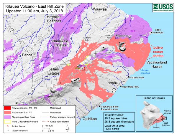
lava map of active lava entries from land to ocean etc. as of July 3rd 2018
Map as of 11:00 a.m. HST, July 3, 2018. Given the dynamic nature of Kīlauea's lower East Rift Zone eruption, with changing vent locations, fissures starting and stopping, and varying rates of lava effusion, map details shown here are accurate as of the date/time noted. Shaded purple areas indicate lava flows erupted in 1840, 1955, 1960, and 2014-2015. (see large map)
end quote from:
https://volcanoes.usgs.gov/volcanoes/kilauea/multimedia_maps.html
Subscribe to:
Post Comments (Atom)
No comments:
Post a Comment