Reports: Lane batters Hawaii with life-threatening flooding, dozens of landslides

By Ashley Williams, AccuWeather staff writer
By Amanda Schmidt, AccuWeather staff writer
August 25, 2018, 11:12:31 PM EDT
Share this article:
As of 5:10 p.m. HST Saturday, the reports below are no longer being updated.
Feet of rain and gusty winds have created catastrophic flooding and left thousands without power across Hawaii as Lane tracked dangerously close to the islands.
"Despite Lane weakening, rain will remain a major threat to the islands," AccuWeather Meteorologist Steve Travis said.
There can be an AccuWeather Local StormMax™ of 60 inches in the steep terrain of the Big Island, leading to more instances of life-threatening and catastrophic flooding and debris flows.

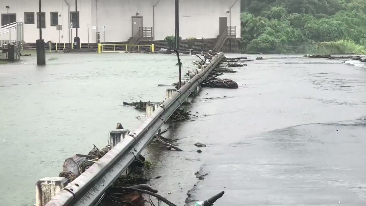
This image shows powerful flash floodwaters in Hilo, Hawaii, with a dangerous flow rate above Rainbow Falls. (Twitter photo/Reed Timmer)
President Donald Trump declared a state of emergency in Hawaii on Wednesday.
The worst conditions are expected into Saturday night as Lane passes dangerously close to the islands. Downpours will persist into early next week, threatening to aggravate ongoing flooding.
Local fire and police departments have urged Big Island residents to evacuate due to the flooding.

This animation shows Tropical Storm Lane spinning west of the Big Island of Hawaii on Saturday, Aug. 25, 2018. (NOAA / GOES Satellite)
The torrents of rain triggered road-blocking landslides on parts of the Big Island starting on Thursday. In Hilo, five people were rescued from a flooded house and taken to a shelter after a nearby gulch overflowed, according to the Associated Press.
Numerous roads remain closed. Even when the heaviest rain eases, residents should remain vigilant of damaged, blocked and flooded roads.
RELATED:
Lane’s extreme rain in Hawaii may approach Harvey’s US rainfall record
Lane looms over Hawaii in these astronaut and satellite photos
Why you should evacuate ahead of a hurricane
1-year anniversary of Harvey's devastation in Texas
Lane’s extreme rain in Hawaii may approach Harvey’s US rainfall record
Lane looms over Hawaii in these astronaut and satellite photos
Why you should evacuate ahead of a hurricane
1-year anniversary of Harvey's devastation in Texas
For previous reports on Lane, click here.
Download the free AccuWeather app for the latest forecast and advisories related to Lane.
3:57 p.m. HST Saturday:
Rainfall amounts of 2 to 3 inches per hour have been pounding the area east of Pahoa, Hawaii.

Prolific rainfall rates from this nearly stationary storm east of Pahoa, HI 2-3" per hour easy. Only good news is this rain is not falling on steep terrain given proximity to shore. Any movement upslope of this rainfall will result in dangerous flash floods @breakingweather #hiwx
12:42 p.m. HST Saturday:
Cleanup is underway after a mudslide covered parts of Highway 19 north of Hilo, Hawaii.
NEW: mudslide cleanup on Highway 19 just north of Hilo, HI at 12 noon with more rain organizing to the southeast. Fire hose setting up again this afternoon/evening @breakingweather @accuweather #TropicalStormLane
9:33 a.m. HST Saturday:
The Maui Bus has resumed fixed-route service as of 7:30 a.m. today.
All landfills have reopened today. However, Molokai Landfill will close early at 1 p.m. HST due to a manpower shortage. Regularly scheduled trash pick-up will start on Monday, August 27.
The Department of Water Supply (DWS) continues to work to restore customers in Haiku after a 4 inch waterline was washed out, affecting customers on Puu Way.
A few announcements from the County of Maui:
The Maui Bus has resumed fixed-route service as of 7:30 a.m. today. MEO will also be providing limited special needs transportation; call 877-7651 for more information.... facebook.com/countyofmaui/p…
DWS also continues to ask West Maui residents to conserve water today while Maui Electric works to get power restored.
All flights are on schedule in airports throughout Maui County.
Road closures include Piiholo Road, Pu'u Way, Piilani Highway, Honokolani, Ulaino and Waikaloa, Haiku Road and Kaupakalua Road.
8:00 a.m. HST Saturday:
The following map from Hawaii County government shows the many incidents of road closures and treacherous driving conditions. The most numerous of which are plaguing the eastern Big Island.

(Image/Hawaii County)
6:30 a.m. HST Saturday:
The U.S. Army Corps of Engineers is deploying a debris management team to Hawaii to help recovery efforts following Lane.
“The engineer team can provide technical support and advice to local authorities who may not be familiar with removal and disposal processes for large amounts of debris. It also can involve physically carrying out various debris removal activities,” the U.S. Army said.
“The Baltimore District also is prepared to deploy its mobile communications vehicle, which provides a full spectrum of communications including radio, satellite and cellular capabilities. The vehicle was deployed to Puerto Rico to help jump-start response and recovery efforts there last fall after Hurricanes Irma and Maria,” the U.S. Army said.
The National Guard is also responding to Tropical Storm Lane and has deployed roughly 400 soldiers in Hawaii.

#HurricaneLane downgrades to a tropical storm after drenching #Hawaii’s Big Island. The @USNationalGuard is ready to support local authorities with recovery efforts if needed. Learn more: go.usa.gov/xUJ87
4:53 a.m. HST Saturday:
Hilo Airport measured 31.85 inches of rain over the three-day period from Aug. 22 to Aug. 24, according to NWS Honolulu. This is the wettest three-day period ever observed at Hilo Airport since record-keeping began in 1949. Hilo also measured 15 inches of rain on Aug. 24, which was the fifth-wettest calendar day on record, the NWS reported.
4:30 a.m. HST Saturday:
Maui Electric informed about 4,800 customers in the West Maui area that an extended power outage may continue through Saturday. Crews are working to repair damaged electrical wires and downed poles in order to restore power. The fire in Maui has restricted some access to affected locations, according to the County of Maui.
2:20 a.m. HST Saturday:
The highest preliminary rainfall total from Lane is 44.88 inches at Waiakea Uka on the Big Island. This is the most rain that a tropical cyclone or rainstorm has produced on Hawaii since Paul drenched the islands with 38.76 inches of rainfall in early November 2000.
AccuWeather is calling for a Local StormMax™ of 60 inches from Lane. That would be the most rain from a tropical cyclone in Hawaii's recorded history. The previous was 52.00 inches from Hurricane Hiki in August 1950. The all-time tropical rain record across the United States was set last year during Harvey with 60.58 inches near Nederland, Texas.
While rainfall has eased over the Hamakua and Hilo Districts, runoff and flooding are ongoing. Numerous road closures are reported, including a full closure of Highway 11 in Kau as well as partial closures of Saddle Road and Highway 130 near Keeau, according to the NWS.

11:45 p.m. HST Friday:
A life-threatening flooding situation is continuing across the Big Island, with persistent rainfall rates of 2-3 inches per hour. This is on top of the heavy rain that has already fallen in the past few days.
Numerous road closures are in place, including Highway 11 between Keeau and Hawaiian Paradise park, according to the NWS.
Motorists are reminded to never attempt to drive through floodwaters. The water may be much deeper than it appears and the roadway underneath could be washed away.

#Maui #Lane our crew sent us this picture from Hana Highway at the bridge at mile marker 17. #turnarounddontdrown
10:30 p.m. HST Friday:
The NWS office in Honolulu has released storm rainfall totals through 9:00 p.m. HST Friday.
On the Big Island, over 40 inches of rain has fallen in Waiakea and Piihonua. On Maui, over 16 inches of rain has fallen in West Wailuaiki.
"Rain bands within the eastern semicircle of Lane's circulation continue to produce torrential rainfall over the Big Island's slopes from Hawi on the north side of the island to Naalehu on the south side," the NWS said. "Significant flash flooding has occurred in multiple areas across the northeast- and east-facing slopes of the island."
9:00 p.m. HST Friday:
Extremely heavy rainfall continues to inundate much of the Big Island, with rainfall rates up to 4 inches per hour being reported.
The National Weather Service (NWS) in Honolulu is warning that this is a very dangerous situation and urging people to avoid travel in the area due to ongoing flood impacts.
Reports that National Guard has abandoned checkpoints in Lower PUNA until the rain stops, due to dangerous flash flooding from persistent 4"/hr rainfall rates! @breakingweather #Lane #PUNA
On Maui, a trained spotter reports that a 30-foot section of Puu Way in Haiku is washed out at a culvert.
7:45 p.m. HST Friday:
Power has been restored to most customers in the Nanakuli area of Oahu, according to Hawaii Electric Light. Nearly 2,000 customers were without power earlier Friday afternoon due to trees on power lines.
715p Nanakuli update: Majority of customers restored. ~120 customers to remain out until crews repair underground cable. Mahalao for your patience. #OahuOutage
Meanwhile, people in Maui are being told to prepare for an extended power outage.
"Due to the high winds from Lane that damaged electrical equipment, Maui Electric is asking about 4,800 customers in the West Maui area currently without power to prepare for an extended outage this evening through Aug. 25," according to a statement from Maui Electric.
A fire that was fanned by Lane's winds earlier on Friday is restricting access to the areas where repairs need to be made to the electrical wires.
6:00 p.m. HST Friday:
Hawaii Governor David Ige held a press conference to discuss the latest impacts of Lane.
The governor announced that Hilo and Kawaihae harbors have been reopened for normal operations.
"We are continuing to work with the Coast Guard and our shipping partners to open the other commercial harbors," he said.
We are not out of the woods yet and could still see flooding and other major impacts. I ask you to remain vigilant. Mahalo to everyone for continuing to look out for your family and your neighbors. #AlohaStrong #HIGov #HINews #HurricaneLane
Ige also reported that all airlines are open and fully operational. "Expect some congestion on Saturday and Sunday as airlines get passengers out," he said.
4:40 p.m. HST Friday:
Lane is now a tropical storm with maximum sustained winds of 70 mph.
Although Lane is no longer a hurricane, it will continue to spread heavy rain across Hawaii that will lead to more flooding into the weekend.
3:15 p.m. HST Friday:
Many roads remain closed across Hawaii due to flooding and landslides.
Over a dozen landslides have occurred on Highway 19 with more possible into the weekend as heavy rain and flooding continues. This road may remain closed for several days as crews work to clear mud, rocks and debris.
Road was opened; however, a second landslide blocked access at MM 25 at 8:50 a.m. Friday, Aug. 24, 2018. Highway 19 near Honomu experienced more than 14 landslides causing four complete road closures.
 Road currently closed at markers 3.5, 6, 15.54, 19, 21.76, 28.5.
Saddle Road/Daniel K. Inouye Highway between markers 8.9 & 11.1 were closed due to water & debris crossing the road. Road reopened to single lane guided access as of 6:15 a.m. Aug. 24. More: bit.ly/2w9xsuY

A landslide blocking both lanes of the Hana Highway in Maui. (Photo/Hawaii DOT)
1:45 p.m. HST Friday:
Lane is becoming very disorganized and is now a Category 1 hurricane. However, the system is nearly stationary and will continue to bring flooding rain to Hawaii into the weekend.
Officials have closed beaches around Honolulu, but many tourists are still swimming and surfing in the dangerous conditions, according to the Associated Press.

A bodyboarder jumps into the surf along Waikiki Beach ahead of Hurricane Lane, Friday, Aug. 24, 2018, in Honolulu. (AP Photo/John Locher)
11:30 a.m. HST Friday:
A brown water advisory has been issued across all of Hawaii due to the significant amount of water flowing into the ocean.
“Hurricane Lane has resulted in storm water runoff entering into coastal waters. The public is advised to stay out of flood waters and storm water runoff due to possible overflowing cesspools, sewer, manholes, pesticides, animal fecal matter, dead animals, pathogens, chemicals and associated flood debris,” the Hawaii Department of Health said.
Officials are saying that if the water appears brown, people should stay out.

A brown water advisory is in effect statewide due to Hurricane #Lane. Not all coastal areas may be impacted by runoff, but if the water is brown stay out. Find the latest information on advisories & health risks & sign up for alerts at eha-cloud.doh.hawaii.gov/cwb/#!/landing #hurricanelane #hiwx
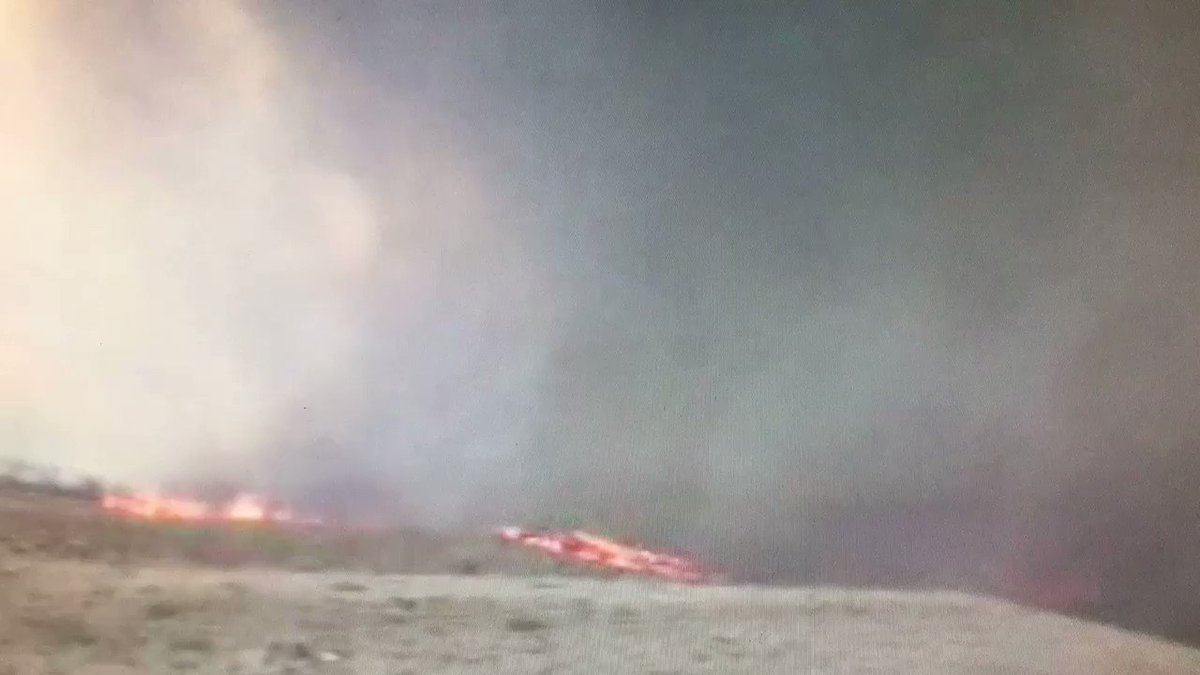
The large brush fires on Maui that are being fanned by winds from Lane have been detected by NOAA weather satellites. Crews are still working to extinguish these fires.

While #HurricaneLane has dumped more than 2 feet of rain on #Hawaii's Big Island, neighboring #Maui is dealing with a large brush fire near the #Lahaina resort area. The Suomi NPP satellite saw the glow of the fire this morning as Lane lurks nearby.
10:00 a.m. HST Friday
As Hurricane Lane continues to approach, airlines continue to cancel their flights to and from Kahului Airport.
American Airlines canceled all flights Friday morning, joining United Airlines, Ohana Airlines, Mokulele Airlines and Aloha Airlines Cargo. Alaska Airlines early flights were canceled between 10 a.m. HST and 2 p.m. HST Friday, according to a County of Maui Facebook post.
Flights are operating today. However, Hurricane #Lane conditions have caused certain West Coast to Maui flights to be delayed, and some interisland flights have been canceled. We encourage guests to please continue checking the status of your flight here: bit.ly/2NgdViZ.
Maui police reopened Honoapiilani Highway in both directions. The highway had been closed earlier due to a large 300-acre brush fire. It is unknown if the fire is related to Hurricane Lane; however, wind gusts overnight helped to spread the fire quickly.
Maui police evacuated more than 100 households at risk from the first brush fire.
The brush fire also forced the closure of the storm evacuation shelter at Lahaina Intermediate. Evacuees were transferred to Lahaina Civic Center. There are approximately 300 evacuees inside the civic center and another 200 on the outside of the property.
It is unknown at this time how many homes were evacuated due to the second brush fire.
There are about 400 evacuees at other local shelters.
One person has been reported injured from the fires. The victim is a female with burns on her arms and legs, according to the County of Maui.
The Department of Water Supply asked that all county and private water customers in Lahaina, Launiupoko and Kaanapali conserve water. This will help ensure that firefighters have enough water to battle the two brush fires.
The Hawaii Department of Transportation reports that heavy rain from the storm is causing potholes on the roads.

Heavy Rain from #Lane causing large potholes. This is HWY 19 at MM 11 on #HawaiiIsland. Please be aware if you are on the road and only get on the road if necessary.

Here’s a photo taken today, Aug. 24, showing some of the damage in Olinda due to the impact of #HurricaneLane passing near the Hawaiian Islands. As of 8 a.m. today, the hurricane is a Category 2 system. We're still expecting major impacts the storm passes through the weekend.
9:15 a.m. HST Friday
Hawaiian Electric spokesman Peter Rosegg said to AP News on Friday that about 6,000 customers in Maui’s Lahaina community have lost power, and some have had it restored.
About 2,600 customers lack power on Molokai, a small island with about 7,000 residents. Power outages affected about 4,000 people on the Big Island.
More than 3,000 lost power overnight on Oahu as strong winds downed tree branches. Most of those affected had service quickly restored, AP News reported.
8:00 a.m. HST Friday
Hurricane Lane is about 170 miles south of Honolulu and 140 miles WSW of Kailua-Kona.
The storm has max sustained winds of 105 mph. Lane is moving toward the north at about 2 mph, and this general motion is expected to continue through tonight, Hawaii Gov. David Ige tweeted.
A second fire broke out on Maui in Kaanapali. Wind gusts are reported up to 50 mph due to Lane, which are fueling the flames.

A second very fast moving fire has broken out in #Maui. Power has been knocked out along kaanapali. much closer to beach and resorts. #hurricanelane
Winds from #hurricaneLane fueling brush fire in Kaanapali in Maui. Residents have been evacuated and now they’re hoping the rain comes soon. #bizarre
6:30 a.m. HST Friday
Approximately 4,000 customers in the West Maui area are without power. The cause of this outage is still being assessed, according to a tweet from Maui Electric.
Maui Electric crews have been redeployed, and they are addressing the issue to bring customers safely back online as quickly as possible. However, work may need to halt if weather conditions worsen.
6:09 a.m. HST Friday
In preparation for Hurricane Lane’s landfall throughout the Hawaiian islands, The American Red Cross has deployed local volunteers and an additional 200 trained disaster workers from across the country, alongside a multitude of supplies and equipment to prepare evacuation centers for residents and tourists escaping the storm.
The evacuation centers, set up by the county government in Hawaii and staffed by The Red Cross, are for those who are in flood-prone areas. They will remain open for 72 hours until the storm has passed and weather conditions are deemed safe.
Although the evacuation centers may transform into emergency shelters post-hurricane, many now do not have cots, running water, food or electricity. The Red Cross is urging those seeking shelter at evacuation centers to bring their own emergency supplies with, such as:
- Water (1 gallon per person per day)
- Food (non-perishable)
- Flashlights
- Radio (NOAA weather radio)
- Extra batteries
- Personal hygiene items
- Cell phone with chargers
To see the entire list of recommended emergency supplies to bring to an evacuation center, go to The Red Cross website.
For residents and tourists that are not in flood-prone areas, The Red Cross suggests preparing enough non-perishable food and water to last at least 14 days. They also advise everyone to have a battery-powered radio, some form of communication, plans for their pets, know the local evacuation routes and listen closely and carefully to local officials in case of an evacuation.
The Red Cross will remain in Hawaii throughout the storm and for post-hurricane relief efforts.
To find the nearest evacuation center, download the free Red Cross Emergency App on your mobile device. Text ‘GETEMERGENCY’ to 90999 to get information sent directly to your device.
5:45 a.m. HST Friday
Approximately 1,358 customers are reported without power from Waimea town to Puukapu Farmlots to lower Kohala Ranch area. First responders en route, according to Hawaii Electric Light.
County of Maui received reports that Hawaiian Tel customers are unable to make or receive phone calls into or out of the Lahaina area at this time.
Cell phone service is also reported to be sporadic, according to the County of Maui.

If you lose power due to Hurricane #Lane:
- Keep freezers & refrigerators closed
- Turn off or disconnect appliances, equipment, & electronics to avoid damage from power surges
- Throw away any food exposed to temps of 40+ degrees for 2 or more hours
- Only use generators outside
4:40 a.m. HST Friday
Parts of the Hawaiian Islands are expected to experience hurricane-force winds mostly in gusts, especially over higher terrain and tall buildings, resulting in wind damage, according to Kottlowski. This could lead to widespread power outages, uprooted trees and flying debris.
Rainfall totals could average 12 to 36 inches in higher-elevated areas, Kottlowski said.
“We are also predicting an AccuWeather Localized StormMax of 50 inches in the more steep-sloped mountain terrain on the Big Island and Maui,” he said. “This extreme rainfall will cause life-threatening flash flooding and mudslides.”
3:30 a.m. HST Friday:
Hurricane Lane's winds are being blamed for starting a brush fire in Lahaina, Maui. Emergency personnel reportedly began responding to the fire in the Kauaula area at about 1 a.m., local time, according to KITV Island News. Residents are being evacuated as the fire, which is estimated to be between 3 and 4 acres, began to spread.
The County of Maui stated on Facebook that the official cause of the fire is currently unknown.
As of 5:45 a.m. HST, fire officials have reported that the fire has jumped Honoapiilani Highway near Dickenson Street and is approaching Aloha Gas Station, according to the County of Maui
Honoapiilani Highway remains closed from Carl’s Junior in Ma’alaea to Shaw Street in Lahaina.
Kahekili Highway is also closed on the Waihee side and is only passable one way, Kapalua to Waihee. However, it is not advisable to drive on due to the weather.
Update 3:30 AM Friday, Aug. 24, 2018 - (Maui) @CountyofMaui reporting Kahekili Highway Lahaina bound is also closed due to the Lahaina fire.
AccuWeather Extreme Meteorologist Reed Timmer reported powerful flash flooding above Hilo, Hawaii, on Thursday.
Strong winds have downed power lines and caused additional power outages in some areas.

1:15 a.m. HST Friday:
NWS Honolulu reports that Hurricane Lane has dropped more than 30 inches of rain in one area of Hawaii's Big Island within the past 24 hours.
11:30 p.m. HST Thursday:
The Hawaii Department of Transportation reports that several roads have been blocked by fallen trees in Maui and the Big Island.
The risk of fallen trees and power outages is expected to increase on Friday as Lane continues on its northward track closer to the islands. With the ground now saturated in many locations, even a modest gust of wind can be enough to knock down trees.
10:15 p.m. HST Thursday:
A brown water advisory has been issued across Hawaii as runoff is entering coastal waters, according to MauiNow.com.
People are being urged to stay out of floodwaters and storm water runoff.
No comments:
Post a Comment