- The Yellowstone Caldera is a volcanic caldera and supervolcano located in Yellowstone National Park in the United States, sometimes referred to as the ...
- Jun 20, 2017 · The supervolcano at Yellowstone National Park has been hit with more than 400 earthquakes since June 12. Researchers say it's nothing to be alarmed about ...
Yellowstone Caldera
From Wikipedia, the free encyclopedia
The Yellowstone Caldera is a volcanic caldera and supervolcano located in Yellowstone National Park in the United States, sometimes referred to as the Yellowstone Supervolcano. The caldera and most of the park are located in the northwest corner of Wyoming. The major features of the caldera measure about 34 by 45 miles (55 by 72 km).[4]Yellowstone Caldera 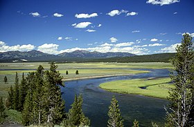 The northeastern part of Yellowstone Caldera, with the Yellowstone River flowing through Hayden Valley and the caldera rim in the distance
Highest point Elevation 9,203[1] ft (2,805 m) Coordinates 44°24′N 110°42′WCoordinates: 44°24′N 110°42′W Geography Location Yellowstone National Park, Wyoming, United States Parent range Rocky Mountains Topo map USGS Yellowstone National Park Geology Age of rock 2,100,000–70,000 years[3] Mountain type Caldera[2] and supervolcano Climbing Easiest route Hike/auto/bus
The caldera formed during the last of three supereruptions over the past 2.1 million years: the Huckleberry Ridge eruption 2.1 million years ago (which created the Island Park Caldera and the Huckleberry Ridge Tuff); the Mesa Falls eruption 1.3 million years ago (which created the Henry's Fork Caldera and the Mesa Falls Tuff); and the Lava Creek eruption approximately 630,000 years ago (which created the Yellowstone Caldera and the Lava Creek Tuff).[5]
Contents
Yellowstone hotspot origin
The source of the Yellowstone hotspot is controversial. Some geoscientists hypothesize that the Yellowstone hotspot is the effect of an interaction between local conditions in the lithosphere and upper mantle convection.[6][7] Others suggest a deep mantle origin (mantle plume).[8] Part of the controversy is the relatively sudden appearance of the hotspot in the geologic record. Additionally, the Columbia Basalt flows appeared at the same approximate time, causing speculation about their origin.[9]
Volcanism
 Volcanism at Yellowstone is relatively recent with calderas that were created during large eruptions that took place 2.1 million, 1.3 million, and 630,000 years ago. The calderas lie over a hotspot where light, hot, molten rock from the mantle rises toward the surface. While the Yellowstone hotspot is now under the Yellowstone Plateau, it previously helped create the eastern Snake River Plain (to the west of Yellowstone) through a series of huge volcanic eruptions. The hotspot appears to move across terrain in the east-northeast direction, but in fact the hotspot is much deeper than terrain and remains stationary while the North American Plate moves west-southwest over it.[10]Yellowstone sits on top of four overlapping calderas. (US NPS)
Over the past 18 million years or so, this hotspot has generated a succession of violent eruptions and less violent floods of basaltic lava. Together these eruptions have helped create the eastern part of the Snake River Plain from a once-mountainous region. At least a dozen of these eruptions were so massive that they are classified as supereruptions. Volcanic eruptions sometimes empty their stores of magma so swiftly that they cause the overlying land to collapse into the emptied magma chamber, forming a geographic depression called a caldera.
The oldest identified caldera remnant straddles the border near McDermitt, Nevada-Oregon, although there are volcaniclastic piles and arcuate faults that define caldera complexes more than 60 km (37 mi) in diameter in the Carmacks Group of southwest-central Yukon, Canada, which are interpreted to have formed 70 million years ago by the Yellowstone hotspot.[11][12] Progressively younger caldera remnants, most grouped in several overlapping volcanic fields, extend from the Nevada-Oregon border through the eastern Snake River Plain and terminate in the Yellowstone Plateau. One such caldera, the Bruneau-Jarbidge caldera in southern Idaho, was formed between 10 and 12 million years ago, and the event dropped ash to a depth of one foot (30 cm) 1,000 miles (1,600 km) away in northeastern Nebraska and killed large herds of rhinoceros, camel, and other animals at Ashfall Fossil Beds State Historical Park. The United States Geological Survey ("USGS") estimates there are one or two major caldera-forming eruptions and 100 or so lava extruding eruptions per million years, and "several to many" steam eruptions per century.[13]
The loosely defined term "supervolcano" has been used to describe volcanic fields that produce exceptionally large volcanic eruptions. Thus defined, the Yellowstone Supervolcano is the volcanic field which produced the latest three supereruptions from the Yellowstone hotspot; it also produced one additional smaller eruption, thereby creating West Thumb Lake[14] 174,000 years ago. The three supereruptions occurred 2.1 million, 1.3 million, and approximately 630,000 years ago, forming the Island Park Caldera, the Henry's Fork Caldera, and Yellowstone calderas, respectively.[15] The Island Park Caldera supereruption (2.1 million years ago), which produced the Huckleberry Ridge Tuff, was the largest and produced 2,500 times as much ash as the 1980 Mount St. Helens eruption. The next biggest supereruption formed the Yellowstone Caldera (~ 630,000 years ago) and produced the Lava Creek Tuff. The Henry's Fork Caldera (1.2 million years ago) produced the smaller Mesa Falls Tuff but is the only caldera from the Snake River Plain-Yellowstone hotspot that is plainly visible today.[16]
Non-explosive eruptions of lava and less-violent explosive eruptions have occurred in and near the Yellowstone caldera since the last supereruption.[17][18] The most recent lava flow occurred about 70,000 years ago, while a violent eruption excavated the West Thumb of Lake Yellowstone around 150,000 years ago. Smaller steam explosions occur as well: an explosion 13,800 years ago left a 5 km (3.1 mi) diameter crater at Mary Bay on the edge of Yellowstone Lake (located in the center of the caldera).[19][3] Currently, volcanic activity is exhibited via numerous geothermal vents scattered throughout the region, including the famous Old Faithful Geyser, plus recorded ground swelling indicating ongoing inflation of the underlying magma chamber.
The volcanic eruptions, as well as the continuing geothermal activity, are a result of a great cove of magma located below the caldera's surface. The magma in this cove contains gases that are kept dissolved by the immense pressure that the magma is under. If the pressure is released to a sufficient degree by some geological shift, then some of the gases bubble out and cause the magma to expand. This can cause a chain reaction. If the expansion results in further relief of pressure, for example, by blowing crust material off the top of the chamber, the result is a very large gas explosion.
According to analysis of earthquake data in 2013, the magma chamber is 80 km (50 mi) long and 20 km (12 mi) wide. It also has 4,000 km3 (960 cu mi) underground mass, of which 6–8% is filled with molten rock. This is about 2.5 times bigger than scientists had previously imagined it to be; however, scientists believe that the proportion of molten rock in the chamber is much too low to allow another supereruption.[20][21]
Hazards
Earthquakes
 Volcanic and tectonic actions in the region cause between 1,000 and 2,000 measurable earthquakes annually. Most are relatively minor, measuring a magnitude of 3 or weaker. Occasionally, numerous earthquakes are detected in a relatively short period of time, an event known as an earthquake swarm. In 1985, more than 3,000 earthquakes were measured over a period of several months. More than 70 smaller swarms were detected between 1983 and 2008. The USGS states these swarms are likely caused by slips on pre-existing faults rather than by movements of magma or hydrothermal fluids.[23][24]Number of earthquakes in Yellowstone National Park region (1973–2014) [22]
In December 2008, continuing into January 2009, more than 500 quakes were detected under the northwest end of Yellowstone Lake over a seven-day span, with the largest registering a magnitude of 3.9.[25][26] The most recent swarm started in January 2010 after the Haiti earthquake and before the Chile earthquake. With 1,620 small earthquakes between January 17, 2010 and February 1, 2010, this swarm was the second largest ever recorded in the Yellowstone Caldera. The largest of these shocks was a magnitude 3.8 which occurred on January 21, 2010.[24][27] This swarm reached the background levels by February 21. On March 30, 2014, at 6:34 AM MST, a magnitude 4.8 earthquake struck Yellowstone, the largest recorded there since February 1980.[28]
Volcanoes
 The last full-scale eruption of the Yellowstone Supervolcano, the Lava Creek eruption which happened approximately 640,000 years ago,[29] ejected approximately 240 cubic miles (1,000 km3) of rock, dust and volcanic ash into the sky.[3]Diagram of the Yellowstone Caldera
Geologists are closely monitoring the rise and fall of the Yellowstone Plateau, which has been rising as fast as 0.6 inches (1.5 cm) per year, as an indication of changes in magma chamber pressure.[30][31]
The upward movement of the Yellowstone caldera floor between 2004 and 2008 — almost 3 inches (7.6 cm) each year — was more than three times greater than ever observed since such measurements began in 1923.[32] From 2004 to 2008, the land surface within the caldera moved upward as much as 8 inches (20 cm) at the White Lake GPS station.[33][34] By the end of 2009, the uplift had slowed significantly and appeared to have stopped.[35] In January 2010, the USGS stated that "uplift of the Yellowstone Caldera has slowed significantly"[36] and that uplift continues but at a slower pace.[37] The U.S. Geological Survey, University of Utah and National Park Service scientists with the Yellowstone Volcano Observatory maintain that they "see no evidence that another such cataclysmic eruption will occur at Yellowstone in the foreseeable future. Recurrence intervals of these events are neither regular nor predictable."[3] This conclusion was reiterated in December 2013 in the aftermath of the publication of a study by University of Utah scientists finding that the "size of the magma body beneath Yellowstone is significantly larger than had been thought." The Yellowstone Volcano Observatory issued a statement on its website stating,
Although fascinating, the new findings do not imply increased geologic hazards at Yellowstone, and certainly do not increase the chances of a 'supereruption' in the near future. Contrary to some media reports, Yellowstone is not 'overdue' for a supereruption.[38]
Other media reports were more hyperbolic in their coverage.[39]
A study published in GSA Today identified three fault zones that future eruptions are most likely to be centered on.[40] Two of those areas are associated with lava flows aged 174,000–70,000 years, and the third area is a focus of present-day seismicity.[40]
Hydrothermal explosions
 Studies and analysis may indicate that the greater hazard comes from hydrothermal activity which occurs independently of volcanic activity. Over 20 large craters have been produced in the past 14,000 years, resulting in such features as Mary Bay, Turbid Lake, and Indian Pond which was created in an eruption about 1300 BC.Path of the Yellowstone hot spot over the past 16 million years
In a 2003 report, USGS researchers proposed that an earthquake may have displaced more than 77 million cubic feet (2,200,000 m3) (576,000,000 US gallons) of water in Yellowstone Lake, creating colossal waves that unsealed a capped geothermal system and led to the hydrothermal explosion that formed Mary Bay.[41][42]
Further research shows that very distant earthquakes reach and have effects upon the activities at Yellowstone, such as the 1992 7.3 magnitude Landers earthquake in California’s Mojave Desert that triggered a swarm of quakes from more than 800 miles (1,300 km) away, and the 2002 7.9 magnitude Denali fault earthquake 2,000 miles (3,200 km) away in Alaska that altered the activity of many geysers and hot springs for several months afterward.[43]
In 2016, the United States Geological Survey announced plans to map the subterranean systems responsible feeding the area's hydrothermal activity. According to the researchers, these maps could help predict when another "super-eruption occurs.[44]
See also
- Iceland hotspot and Iceland plume describes aspects of volcanic processes
- Long Valley Caldera, Valles Caldera, La Garita Caldera: examples of other calderas close to but not related to Yellowstone.
References
- USGS. "Yellowstone Volcano Observatory". United States Geological Survey.


- "We're About to Find Out What's Rumbling Below The Yellowstone Supervolcano". Science Alert. Retrieved 22 May 2017.
Further reading
- Breining, Greg (2007). Super Volcano: The Ticking Time Bomb beneath Yellowstone National Park. St. Paul, MN: Voyageur Press. ISBN 978-0-7603-2925-2.
A popularized scientific look at the Yellowstone area's geological past and potential future
- Vazquez, J.A.; Reid, M.R. (2002). "Time scales of magma storage and differentiation of voluminous rhyolites at Yellowstone caldera". Contributions to Mineralogy & Petrology. Wyoming. 144 (3): 274–285. Bibcode:2002CoMP..144..274V. doi:10.1007/s00410-002-0400-7.
- Sutherland, Wayne; Sutherland, Judy (2003). Yellowstone Farewell. Spur Ridge.
A novel looking at an eruption in the Yellowstone Caldera written by a practicing Wyoming geologist. Contains a wealth of technical details on the geology of western Wyoming
External links
- The Snake River Plain and the Yellowstone Hot Spot
- Yellowstone Volcano Observatory
- Supervolcano documentary from BBC
- Interactive: When Yellowstone Explodes from National Geographic
- The Yellowstone magmatic system from the mantle plume to the upper crust (46,000 km3 magma reservoir below chamber)
Categories:
- Yellowstone Caldera
- Landforms of Park County, Wyoming
- Landforms of Teton County, Wyoming
- Landforms of Yellowstone National Park
- Active volcanoes
- Supervolcanoes
- Extinction events
- Complex volcanoes
- Hotspot volcanoes
- VEI-8 volcanoes
- Volcanism of Wyoming
- Volcanism of Idaho
- Volcanoes of Wyoming
- Volcanoes of Idaho
- Volcanic calderas of the United States
- Snake River
- Potentially active volcanoes
- Yellowstone hotspot
No comments:
Post a Comment