Originally erected 4500 years ago, Avebury is the largest stone circle in the world . In the Old Farmyard you'll find the Alexander Keiller Museum: your gateway to ...
Avebury
From Wikipedia, the free encyclopedia
This article is about the prehistoric site. For the modern village and civil parish containing it, see
Avebury, Wiltshire.
(
) is a
Neolithic henge monument containing three stone circles, around the
village of Avebury in
Wiltshire,
in southwest England. One of the best known prehistoric sites in
Britain, it contains the largest megalithic stone circle in the world,
and is both a tourist attraction and a place of religious importance to
contemporary pagans.
Constructed over several hundred years in the Third Millennium BC,
[1] during the
Neolithic, or New Stone Age, the monument comprises a large
henge
(a bank and a ditch) with a large outer stone circle and two separate
smaller stone circles situated inside the centre of the monument. Its
original purpose is unknown, although archaeologists believe that it was
most likely used for some form of ritual or ceremony. The Avebury
monument is a part of a larger prehistoric landscape containing several
older monuments nearby, including
West Kennet Long Barrow and
Silbury Hill.
By the
Iron Age, the site had been effectively abandoned, with some evidence of human activity on the site during the
Roman occupation.
During the Early Middle Ages, a village first began to be built around
the monument, eventually extending into it. In the Late Medieval and
Early Modern periods, local people destroyed many of the standing stones
around the henge, both for religious and practical reasons. The
antiquarians
John Aubrey and
William Stukeley, however, took an interest in Avebury during the 17th century, and recorded much of the site before its destruction.
Archaeological investigation followed in the 20th century, led primarily by
Alexander Keiller, who oversaw a project which reconstructed much of the monument.
Avebury is owned and managed by the
National Trust.
[2] It has been designated a
Scheduled Ancient Monument,
[3] as well as a
World Heritage Site, in the latter capacity being seen as a part of the wider prehistoric landscape of Wiltshire known as
Stonehenge, Avebury and Associated Sites.
[4]
Location and environment
Avebury Henge and village
At
grid reference SU10266996,
[3] Avebury is respectively about 6 and 7 miles (10 and 11 km) from the modern towns of
Marlborough and
Calne. Avebury lies in an area of chalkland in the
Upper Kennet Valley which forms the
catchment
for the River Kennet and supports local springs and seasonal
watercourses. The monument stands slightly above the local landscape,
sitting on a low chalk ridge 160 m (520 ft) above sea level; to the east
are the
Marlborough Downs,
an area of lowland hills. The site lies at the centre of a collection
of Neolithic and early Bronze Age monuments and was inscribed as a
World Heritage Site in a co-listing with the monuments at Stonehenge, 17 miles (27 km) to the south, in 1986. It is now listed as part of the
Stonehenge, Avebury and Associated Sites World Heritage Site.
[2]
The monuments are preserved as part of a Neolithic and Bronze Age
landscape for the information they provide regarding prehistoric
people's relationship with the landscape.
[5]
Boundary and key sites for the Avebury section of the Stonehenge and Avebury World Heritage Site
Radiocarbon dating
and analysis of pollen in buried soils have shown that the environment
of lowland Britain changed around 4250–4000 BCE. The change to a
grassland
environment from damp, heavy soils and expanses of dense forest was
mostly brought about by farmers, probably through the use of
slash and burn
techniques. Environmental factors may also have made a contribution.
Pollen is poorly preserved in the chalky soils found around Avebury, so
the best evidence for the state of local environment at any time in the
past comes from the study of the deposition of
snail
shells. Different species of snail live in specific habitats, so the
presence of a certain species indicates what the area was like at a
particular point in time.
[6] The available evidence suggests that in the early Neolithic, Avebury and the surrounding hills were covered in dense
oak
woodland, and as the Neolithic progressed, the woodland around Avebury
and the nearby monuments receded and was replaced by grassland.
[7]
Background
The
history of the site before the construction of the henge is uncertain,
because little datable evidence has emerged from modern
archaeological excavations.
[8] Evidence of activity in the region before the 4th millennium BCE is limited, suggesting that there was little human occupation.
Mesolithic
What is now termed the
Mesolithic period in Britain lasted from circa 11600 to 7800
BP, at a time when the island was heavily forested and when there was still a land mass, called
Doggerland, which connected Britain to continental Europe.
[9] During this era, those humans living in Britain were
hunter-gatherers,
often moving around the landscape in small familial or tribal groups in
search of food and other resources. Archaeologists have unearthed
evidence that there were some of these hunter-gatherers active in the
vicinity of Avebury during the Late Mesolithic, with stray finds of
flint tools, dated between 7000 and 4000 BCE, having been found in the area.
[10]
The most notable of these discoveries is a densely scattered collection
of worked flints found 300 m (980 ft) to the west of Avebury, which has
led archaeologists to believe that that particular spot was a flint
working site occupied over a period of several weeks by a group of
nomadic hunter-gatherers who had set up camp there.
[11]
The archaeologists Mark Gillings and
Joshua Pollard
suggested the possibility that Avebury first gained some sort of
ceremonial significance during the Late Mesolithic period. As evidence,
they highlighted the existence of a
posthole
near to the monument's southern entrance that would have once supported
a large wooden post. Although this posthole was never dated when it was
excavated in the early 20th century, and so cannot definitely be
ascribed to the Mesolithic, Gillings and Pollard noted that its
positioning had no relation to the rest of the henge, and that it may
therefore have been erected centuries or even millennia before the henge
was actually built.
[12] They compared this with similar wooden posts that had been erected in southern Britain during the Mesolithic at
Stonehenge and
Hambledon Hill, both of which were sites that like Avebury saw the construction of large monuments in the Neolithic.
[13]
Early Neolithic
In the 4th millennium BCE, around the start of the Neolithic period
in Britain, British society underwent radical changes. These coincided
with the introduction to the island of domesticated species of animals
and plants, as well as a changing
material culture
that included pottery. These developments allowed hunter-gatherers to
settle down and produce their own food. As agriculture spread, people
cleared land. At the same time, they also erected the first monuments to
be seen in the local landscape, an activity interpreted as evidence of a
change in the way people viewed their place in the world.
[12]
Based on
anthropological
studies of recent and contemporary societies, Gillings and Pollard
suggest that forests, clearings, and stones were important in Neolithic
culture, not only as resources but as symbols; the site of Avebury
occupied a convergence of these three elements.
[14] Neolithic activity at Avebury is evidenced by flint, animal bones, and pottery such as
Peterborough ware
dating from the early 4th and 3rd millennia BCE. Five distinct areas of
Neolithic activity have been identified within 500 m (1,600 ft) of
Avebury; they include a scatter of flints along the line of the
West Kennet Avenue – an
avenue that connects Avebury with the Neolithic site of
The Sanctuary. Pollard suggests that areas of activity in the Neolithic became important markers in the landscape.
[15]
Late Neolithic
"After over a thousand years of early farming, a way of life based on
ancestral tombs, forest clearance and settlement expansion came to an
end. This was a time of important social changes."
Archaeologist and prehistorian Mike Parker Pearson on the Late Neolithic in Britain (2005)[16]
During the Late Neolithic, British society underwent another series
of major changes. Between 3500 and 3300 BCE, these prehistoric Britons
ceased their continual expansion and cultivation of wilderness and
instead focused on settling and farming the most agriculturally
productive areas of the island: Orkney, eastern Scotland, Anglesey, the
upper Thames, Wessex, Essex, Yorkshire and the river valleys of the
Wash.
[17]
Late Neolithic Britons also appeared to have changed their religious
beliefs, ceasing to construct the large chambered tombs that are widely
thought by archaeologists to have been connected with
ancestor veneration.
Instead, they began the construction of large wooden or stone circles,
with many hundreds being built across Britain and Ireland over a period
of a thousand years.
[18]
Construction
The north-west sector of Avebury
The chronology of Avebury's construction is unclear. It was not
designed as a single monument, but is the result of various projects
that were undertaken at different times during late prehistory.
[19] Aubrey Burl
suggests dates of 3000 BC for the central cove, 2900 BC for the inner
stone circle, 2600 BC for the outer circle and henge, and around 2400 BC
for the avenues.
[1]
The construction of large monuments such as those at Avebury
indicates that a stable agrarian economy had developed in Britain by
around 4000–3500 BCE. The people who built them had to be secure enough
to spend time on such non-essential activities. Avebury was one of a
group of monumental sites that were established in this region during
the Neolithic. Its monuments comprise the henge and associated
long barrows, stone circles, avenues, and a
causewayed enclosure.
These monument types are not exclusive to the Avebury area. For
example, Stonehenge features the same kinds of monuments, and in
Dorset there is a henge on the edge of
Dorchester and a causewayed enclosure at nearby
Maiden Castle.
[20] According to Caroline Malone, who worked for
English Heritage
as an inspector of monuments and was the curator of Avebury's Alexander
Keiller Museum, it is possible that the monuments associated with
Neolithic sites such as Avebury and Stonehenge constituted ritual or
ceremonial centres.
[20]
Archaeologist
Mike Parker Pearson
noted that the addition of the stones to the henge occurred at a
similar date to the construction of Silbury Hill and the major building
projects at Stonehenge and
Durrington Walls.
For this reason, he speculated that there may have been a "religious
revival" at the time, which led to huge amounts of resources being
expended on the construction of ceremonial monuments.
[21]
Archaeologist Aaron Watson highlighted the possibility that by
digging up earth and using it to construct the large banks, those
Neolithic labourers constructing the Avebury monument symbolically saw
themselves as turning the land "inside out", thereby creating a space
that was "on a frontier between worlds above and beneath the ground."
[22]
Henge
The Avebury monument is a
henge,
a type of monument consisting of a large circular bank with an internal
ditch. The henge is not perfectly circular and measures over 1,000
metres (1,090 yd) in circumference.
[23] The only known comparable sites of similar date are only a quarter of the size of Avebury.
Radiocarbon dating suggests that the henge was made by the middle of the third millennium BC.
[24] The henge's construction was an immense task; the ditch was cut through hard chalk with antler picks and stone
mauls, and it is estimated that over
90000 m3 of material weighing 165,000 tons was excavated.
[23]
The ditch is currently 20–24 metres wide, but originally was narrower
at 12–15 metres with sides sharply dropping to a bottom around 10 metres
deep. Burl speculates that it was likely built for defensive purposes.
[23]
The top of the bank is irregular, something archaeologist
Caroline Malone
suggested was because of the irregular nature of the work undertaken by
excavators working on the adjacent sectors of the ditch.
[25]
Later archaeologists such as Aaron Watson, Mark Gillings and Joshua
Pollard have, however, suggested that this was an original Neolithic
feature of the henge's architecture.
[26][27]
Outer Stone Circle
Within the henge is a great outer circle. This is one of Europe's largest stone circles,
[28] with a diameter of 331.6 metres (1,088 ft), Britain's largest stone circle.
[29]
It was either contemporary with, or built around four or five centuries
after the earthworks. It is thought that there were originally 98
sarsen standing stones,
some weighing in excess of 40 tons. The stones varied in height from
3.6 to 4.2 m, as exemplified at the north and south entrances.
Radiocarbon dating of some stone settings indicate a construction date
of around 2870–2200 BC.
[30]
The two large stones at the Southern Entrance had an unusually smooth surface, likely due to having stone axes polished on them.
[31]
Inner Stone Circles
Nearer
the middle of the monument are two additional, separate stone circles.
The northern inner ring is 98 metres (322 ft) in diameter, but only two
of its four standing stones remain upright. A
cove of three stones stood in the middle, its entrance facing northeast.
[citation needed] Taking experiments undertaken at the megalithic
Ring of Brodgar in
Orkney as a basis, the archaeologists
Joshua Pollard,
Mark Gillings and Aaron Watson believed that any sounds produced inside
Avebury's Inner Circles would have created an echo as sound waves
ricocheted off the standing stones.
[31][32]
The southern inner ring was 108 metres (354 ft) in diameter before
its destruction in the 18th century. The remaining sections of its arc
now lie beneath the village buildings. A single large monolith, 5.5
metres (18 ft) high, stood in the centre along with an alignment of
smaller stones.
[citation needed]
The Avenue
The
West Kennet Avenue, an
avenue of paired stones, leads from the southeastern entrance of the henge; and traces of a second, the
Beckhampton Avenue, lead out from the western entrance.
[citation needed]
The archaeologist Aaron Watson, taking a
phenomenological
viewpoint to the monument, believed that the way in which the Avenue
had been constructed in juxtaposition to Avebury, the Sanctuary, Silbury
Hill and West Kennet Long Barrow had been intentional, commenting that
"the Avenue carefully orchestrated passage through the landscape which
influenced how people could move and what they could see, emphasizing
connections between places and maximizing the spectacle of moving
between these monuments."
[33]
Purpose
The postulated original layout of Avebury, published in a late 19th-century edition of the Swedish encyclopaedia
Nordisk familjebok. Original illustration by
John Martin, based on an illustration by
John Britton
The purpose which Neolithic people had for the Avebury monument has
remained elusive, although many archaeologists have postulated about its
meaning and usage.
[34] Archaeologist
Aubrey Burl
believed that rituals would have been performed at Avebury by Neolithic
peoples in order "to appease the malevolent powers of nature" that
threatened their existence, such as the winter cold, death and disease.
[35]
In his study of those examples found at
Orkney,
Colin Richards suggested that the stone and wooden circles built in
Neolithic Britain might have represented the centre of the world, or
axis mundi, for those who constructed them,
[36] something Aaron Watson adopted as a possibility in his discussion of Avebury.
[26]
A great deal of interest surrounds the morphology of the stones,
which are usually described as being in one of two categories; tall and
slender, or short and squat. This has led to numerous theories relating
to the importance of gender in
Neolithic Britain
with the taller stones considered "male" and the shorter ones "female".
The stones were not dressed in any way and may have been chosen for
their pleasing natural forms.
The human bones found by Gray point to some form of funerary purpose
and have parallels in the disarticulated human bones often found at
earlier
causewayed enclosure
sites. Ancestor worship on a huge scale could have been one of the
purposes of the monument and would not necessarily have been mutually
exclusive with any male/female
ritual role.
The henge, although clearly forming an imposing boundary to the
circle, could have had a purpose that was not defensive as the ditch is
on the inside (this is the defining characteristic of a
Henge.)
Being a henge and stone circle site, astronomical alignments are a
common theory to explain the positioning of the stones at Avebury. The
relationships between the causewayed enclosure, Avebury stone circles,
and
West Kennet Long Barrow
to the south, has caused some to describe the area as a "ritual
complex" – a site with many monuments of interlocking religious
function.
[37]
Controversial theories
Various non-archaeologists as well as
pseudoarchaeologists
have interpreted Avebury and its neighbouring prehistoric monuments
differently from academics. These interpretations have been defined by
professional archaeologist Aubrey Burl as being "more phony than
factual", and in many cases "entirely untenable".
[38] Such inaccurate ideas originated with
William Stukeley in the late 17th century, who believed that Avebury had been built by the
druids,
priests of the Iron Age peoples of north-western Europe, although
archaeologists since then have identified the monument as having been
constructed two thousand years before the Iron Age, during the
Neolithic.
[39]
Panoramic view of the southern end of the monument
Following Stukeley, other writers produced inaccurate theories about
how Avebury was built and by whom. The Reverend R. Weaver, in his
The Pagan Altar (1840) argued that both Avebury and Stonehenge were built by
Phoenicians, an ancient seafaring people whom many Victorian Britons believed had first brought civilisation to the island.
[40] James Fergusson disagreed, and in his
Rude Stone Monuments in All Countries
(1872) put forward the idea that the megalithic monument had been
constructed in the Early Mediaeval period to commemorate the final
battle of
King Arthur, and that Arthur's slain warriors had been buried there.
[41] W. S. Blacket introduced a third idea, arguing in his
Researches into the Lost Histories of America (1883) that it was
Native Americans from the
Appalachian Mountains who, in the ancient period crossed the Atlantic Ocean to build the great megalithic monuments of southern Britain.
[42]
The prominent modern Druid
Ross Nichols, the founder of the
Order of Bards, Ovates and Druids,
believed that there was an astrological axis connecting Avebury to the
later megalithic site at Stonehenge, and that this axis was flanked on
one side by
West Kennet Long Barrow, which he believed symbolised the Mother Goddess, and
Silbury Hill, which he believed to be a symbol of masculinity.
[43]
Alexander Thom suggested that Avebury was constructed with a site-to-site alignment with
Deneb.
[44]
Later history
Iron Age and Roman periods
During the
British Iron Age,
it appears that the Avebury monument had ceased to be used for its
original purpose, and was instead largely ignored, with little
archaeological evidence that many people visited the site at this time.
Archaeologist
Aubrey Burl
believed that the Iron Age Britons living in the region would not have
known when, why or by whom the monument had been constructed, perhaps
having some vague understanding that it had been built by an earlier
society or considering it to be the dwelling of a supernatural entity.
[45]
In 43 CE, the
Roman Empire
invaded southern Britain, making alliances with certain local monarchs
and subsuming the Britons under their own political control. Southern
and central Britain would remain a part of the Empire until the early
5th century, in a period now known as
Roman Britain or the Roman Iron Age. It was during this Roman period that tourists came from the nearby towns of
Cunetio,
Durocornovium and the villas and farms around
Devizes and visited Avebury and its surrounding prehistoric monuments via a newly constructed road.
[45]
Evidence of visitors at the monument during this period has been found
in the form of Roman-era pottery sherds uncovered from the ditch.
[46]
Early Mediaeval period
In the
Early Mediaeval period, which began in the 5th century following the collapse of Roman rule,
Anglo-Saxon tribes from continental Europe
migrated to southern Britain,
where they may have come into conflict with the Britons already settled
there. Aubrey Burl suggested the possibility that a small group of
British warriors may have used Avebury as a fortified site to defend
themselves from Anglo-Saxon attack. He gained this idea from
etymological evidence, suggesting that the site may have been called
weala-dic, meaning "moat of the Britons", in
Old English, the language of the Anglo-Saxons.
[47][48]
The early Anglo-Saxon settlers followed
their own pagan religion which venerated a selection of deities, the most notable of whom were apparently
Woden and
Thunor.
It is known from etymological sources that they associated many
prehistoric sites in the Wiltshire area with their gods, for instance
within a ten-mile of radius of Avebury there are four sites that were
apparently named after Woden:
Wansdyke ("Wodin's ditch"),
Wodin's Barrow, Waden Hill ("Wodin's Hill)" and perhaps Wanborough (also "Woden's Hill").
[49] It is not known if they placed any special religious associations with the Avebury monument, but it remains possible.
[49]
During the Early Mediaeval period, there were signs of settlement at Avebury, with a
grubenhaus, a type of timber hut with a sunken floor, being constructed just outside the monument's west bank in the 6th century.
[50] Only a few farmers appeared to have inhabited the area at the time, and they left the Avebury monument largely untouched.
[50]
In the 7th and 8th centuries, the Anglo-Saxon peoples began gradually
converting to Christianity, and during the 10th century a church was
built just west of the monument.
[50]
In 939, the earliest known written record of the monument was made in the form of a charter of
King Athelstan which defined the boundaries of
Overton, a parish adjacent to Avebury.
[50] In the following century, invading
Viking
armies from Denmark came into conflict with Anglo-Saxon groups in the
area around Avebury, and it may be that they destroyed Avebury village,
for the local prehistoric monument of
Silbury Hill
was fortified and used as a defensive position, apparently by a local
Anglo-Saxon population attempting to protect themselves from Viking
aggression.
[50]
Late Mediaeval period
The skeletal remains of the man, likely a barber-surgeon, who was killed
in an accident whilst trying to topple the stones at Avebury in the
early 14th century.
By the
Late Mediaeval period,
England had been entirely converted to Christianity, and Avebury, being
an evidently non-Christian monument, began to be associated with the
Devil
in the popular imagination of the locals. The largest stone at the
southern entrance became known as the Devil's Chair, the three stones
that once formed the Beckhampton Cove became known as the Devil's Quoits
and the stones inside the North Circle became known as the Devil's
Brand-Irons.
[51]
At some point in the early 14th century, villagers began to demolish
the monument by pulling down the large standing stones and burying them
in ready-dug pits at the side, presumably because they were seen as
having been erected by the Devil and thereby being in opposition to the
village's Christian beliefs.
[52]
Although it is unknown how this situation came about, archaeologist
Aubrey Burl suggests that it might have been at the prompting of the
local Christian priest, with the likely contenders being either Thomas
Mayn (who served in the village from 1298 to 1319), or John de Hoby (who
served from 1319 to 1324).
[53]
During the toppling of the stones, one of them (which was 3 metres tall and weighed 13 tons), collapsed on top of
one of the men
pulling it down, fracturing his pelvis and breaking his neck, crushing
him to death. His corpse was trapped in the hole that had been dug for
the falling stone, and so the locals were unable to remove the body and
offer him a Christian burial in a churchyard, as would have been
customary at the time. When archaeologists excavated his body in 1938,
they found that he had been carrying a leather pouch, in which was found
three silver coins dated to around 1320–25, as well as a pair of iron
scissors and a lancet. From these latter two items, the archaeologists
surmised that he had probably been a travelling
barber-surgeon
who journeyed between market towns offering his services, and that he
just happened to be at Avebury when the stone-felling was in progress.
[54]
It appears that the death of the barber-surgeon prevented the locals
from pulling down further stones, perhaps fearing that it had in some
way been retribution for toppling them in the first place, enacted by a
vengeful spirit or even the Devil himself.
[55]
The event appears to have left a significant influence on the minds of
the local villagers, for records show that in the 18th and 19th
centuries there were still legends being told in the community about a
man being crushed by a falling stone.
[55]
Soon after the toppling of many of the stones, the
Black Death
hit the village in 1349, almost halving the population. Those who
survived focused on their agricultural duties to grow food and stay
alive. As a result, they would not have had the time or manpower to once
more attempt to demolish any part of the non-Christian monument, even
if they wanted to.
[56]
Early Modern period
It was in the
Early Modern period that Avebury was first recognised as an
antiquity that warranted investigation. Around 1541,
John Leland, the librarian and chaplain to
King Henry VIII travelled through Wiltshire and made note of the existence of Avebury and its neighbouring prehistoric monuments.
[57] Despite this, Avebury remained relatively unknown to anyone but locals and when the antiquarian
William Camden published his Latin language guide to British antiquities,
Britannia,
in 1586, he made no mention of it. He rectified this for his English
language version in 1610, but even in this he only included a fleeting
reference to the monument at "Abury", believing it to have been "an old
camp".
[58] In 1634, it was once more referenced, this time in
Sir John Harington's notes to the
Orlando Furioso opera;
[58] however, further antiquarian investigation was prevented by the outbreak of the
English Civil War (1642–51), which was waged between the
Parliamentarians and
Royalists, with one of the battles in the conflict taking place five miles away from Avebury at
Roundway Down.
[58]
With the war over, a new edition of the
Britannia was
published in 1695, which described the monument at "Aubury" in more
detail. This entry had been written by the antiquarian and writer
John Aubrey,
who privately made many notes about Avebury and other prehistoric
monuments which remained unpublished. Aubrey had first encountered the
site whilst out hunting in 1649 and, in his own words, had been
"wonderfully surprised at the sight of those vast stones of which I had
never heard before."
[59] Hearing of Avebury and taking an interest in it,
King Charles II
commanded Aubrey to come to him and describe the site, which he did in
July 1663. The two subsequently travelled to visit it together on the
monarch's trip to
Bath, Somerset
a fortnight later, and the site further captivated the king's interest,
who commanded Aubrey to dig underneath the stones in search of any
human burials. Aubrey, however, never undertook the king's order.
[59]
In September 1663, Aubrey began making a more systematic study of the
site, producing a plan that has proved invaluable for later
archaeologists, for it contained reference to many standing stones that
would soon after be destroyed by locals.
[60]
In the latter part of the 17th and then the 18th centuries,
destruction at Avebury reached its peak, possibly influenced by the rise
of
Puritanism in the village, a fundamentalist form of
Protestant Christianity that vehemently denounced things considered to be "pagan", which would have included pre-Christian monuments like Avebury.
[61]
The majority of the standing stones that had been a part of the
monument for thousands of years were smashed up to be used as building
material for the local area. This was achieved in a method that involved
lighting a fire to heat the sarsen, then pouring cold water on it to
create weaknesses in the rock, and finally smashing at these weak points
with a sledgehammer.
[61]
William Stukeley's drawing of the stones being broken up by fire
[62]
In 1719, the antiquarian
William Stukeley
visited the site, where he witnessed the destruction being undertaken
by the local people. Between then and 1724 he visited the village and
its monument six times, sometimes staying for two or three weeks at the
Catherine Wheel Inn. In this time, he made meticulous plans of the site,
considering it to be a "British Temple", and believing it to having
been fashioned by the
druids,
the Iron Age priests of north-western Europe, in the year 1859 BCE. He
developed the idea that the two Inner Circles were a temple to the moon
and to the sun respectively, and eventually came to believe that Avebury
and its surrounding monuments were a landscaped portrayal of the
Trinity, thereby backing up his erroneous ideas that the ancient druids had been followers of a religion very much like Christianity.
[63]
Stukeley was disgusted by the destruction of the sarsen stones in the
monument, and named those local farmers and builders who were
responsible.
[64]
He remarked that "this stupendous fabric, which for some thousands of
years, had brav'd the continual assaults of weather, and by the nature
of it, when left to itself, like the
pyramids of
Egypt, would have lasted as long as the
globe, hath fallen a sacrifice to the wretched ignorance and avarice of a little village unluckily plac'd within it."
[65]
Stukeley published his findings and theories in a book,
Abury, a Temple of the British Druids
(1743), in which he intentionally falsified some of the measurements he
had made of the site to better fit his theories about its design and
purpose.
[66] Meanwhile, the Reverend Thomas Twining had also published a book about the monument,
Avebury in Wiltshire, the Remains of a Roman Work,
which had been published in 1723. Whereas Stukeley claimed that Avebury
and related prehistoric monuments were the creations of the druids,
Twining thought that they had been constructed by the later Romans,
justifying his conclusion on the fact that Roman writers like
Julius Caesar and
Tacitus had not referred to stone circles when discussing the Iron Age Britons, whereas Late Mediaeval historians like
Geoffrey of Monmouth and
Henry of Huntingdon
had described these megaliths in their works, and that such monuments
must have therefore been constructed between the two sets of accounts.
[67]
Late Modern period
By the beginning of the
Victorian period
in 1837, the majority of Neolithic standing stones at Avebury had gone,
having been either buried by pious locals in the 14th century or
smashed up for building materials in the 17th and 18th. Meanwhile, the
population of Avebury village was rapidly increasing, leading to further
housing being built inside the henge. In an attempt to prevent further
construction on the site, the wealthy politician and archaeologist
Sir John Lubbock,
who later came to be known as Lord Avebury, purchased much of the
available land in the monument, and encouraged other buyers to build
their houses outside rather than within the henge, in an attempt to
preserve it.
[68]
Following the opening of his own excavations, archaeologist
Alexander Keiller decided that the best way to preserve Avebury was to purchase it in its entirety. Keiller was heir to the
James Keiller and Son
business and was able to use his wealth to acquire the site. He also
obtained as much of the Kennet Avenue as possible and the nearby
Avebury Manor, where he was to live until his death in 1955.
[69]
Excavation at Avebury has been limited. In 1894 Sir Henry Meux put a
trench through the bank, which gave the first indication that the
earthwork was built in two phases. The site was surveyed and excavated
intermittently between 1908 and 1922 by a team of workmen under the
direction of
Harold St George Gray. The discovery of over 40 antler picks on or near the bottom of the ditch
[70] enabled Gray to demonstrate that the Avebury builders had dug down 11 metres (36 ft) into the natural chalk using
red deer
antlers as their primary digging tool, producing a henge ditch with a
9-metre (30 ft) high bank around its perimeter. Gray recorded the base
of the ditch as being 4 metres (13 ft) wide and flat, but later
archaeologists have questioned his use of untrained labour to excavate
the ditch and suggested that its form may have been different. Gray
found few
artefacts
in the ditch-fill but he did recover scattered human bones, amongst
which jawbones were particularly well represented. At a depth of about 2
metres (7 ft), Gray found the complete skeleton of a 1.5-metre (5 ft)
tall woman.
[71][72]
During the 1930s archaeologist Alexander Keiller re-erected many of the stones. Under one, now known as the
Barber Stone,
the skeleton of a man was discovered. Coins dating from the 1320s were
found with the skeleton, and the evidence suggests that the man was
fatally injured when the stone fell on him whilst he was digging the
hole in which it was to be buried in a mediaeval "rite of destruction".
As well as the coins Keiller found a pair of scissors and a
lancet, the tools of a barber-surgeon at that time, hence the name given to the stone.
[73][74]
When a new village school was built in 1969 there was a further
opportunity to examine the site, and in 1982 an excavation to produce
carbon dating material and environmental data was undertaken.
[citation needed]
In April 2003, during preparations to straighten some of the stones,
one was found to be buried at least 2.1 metres (7 ft) below ground. It
was estimated to weigh more than 100 tons, making it one of the largest
ever found in the UK.
[75] Later that year, a
geophysics
survey of the southeast and northeast quadrants of the circle by the
National Trust revealed at least 15 of the megaliths lying buried. The
National Trust were able to identify their sizes, the direction in which
they are lying, and where they fitted in the circle.
[76][77]
Alexander Keiller Museum
The Barn Gallery of the Alexander Keiller Museum
The
Alexander Keiller Museum features the
prehistoric artifacts collected by archaeologist and businessman
Alexander Keiller, which include many artifacts found at Avebury. The museum is located in the 17th-century stables gallery, and is operated by
English Heritage and the
National Trust. The nearby 17th-century
threshing barn houses a permanent exhibit gallery about Avebury and its history.
Founded by Keiller in 1938, the collections feature artifacts mostly of
Neolithic and
Early Bronze Age date, with other items from the
Anglo-Saxon and later periods. The museum also features the skeleton of a child nicknamed "
Charlie", found in a ditch at
Windmill Hill, Avebury. The
Council of British Druid Orders requested that the skeleton be re-buried in 2006,
[78] but in April 2010 the decision was made to keep the skeleton on public view.
The collections are owned by the
Department for Culture, Media and Sport and are on loan to English Heritage.
[79]
Contemporary use
Contemporary Paganism and the New Age movement
Avebury has been adopted as a sacred site by many adherents of
contemporary Pagan religions such as
Druidry,
Wicca and
Heathenry. These worshippers view the monument as a "living temple" which they associate with the ancestors, as well as with
genii loci, or spirits of place.
[80]
Typically, such Pagan rites at the site are performed publicly, and
attract crowds of curious visitors to witness the event, particularly on
major days of Pagan celebration such as the
summer solstice.
[81]
Druidic rites held at Avebury are commonly known as
gorseddau and involve participants invoking
Awen (a Druidic concept meaning inspiration), with an
eisteddfod section during which poems, songs and stories are publicly performed. The Druid Prayer composed by
Iolo Morganwg
in the 18th century and the later Druid Vow are typically recited. One
particular group, known as the Gorsedd of Bards of Caer Abiri, focus
almost entirely upon holding their rites at the prehistoric site,
[82] referring to it as
Caer Abiri.
[83] In their original ceremony, composed by
Philip Shallcrass of the
British Druid Order
in 1993, those assembled divide into two groups, one referred to as the
God party and the other as the Goddess party. Those with the Goddess
party go to the "Devil's Chair" at the southern entrance to the Avebury
henge, where a woman representing the spirit guardian of the site and
the Goddess who speaks through her sits in the chair-like cove in the
southern face of the sarsen stone. Meanwhile, those following the God
party process around the outer bank of the henge to the southern
entrance, where they are challenged as to their intent and give
offerings (often of flowers, fruit, bread or
mead) to the Goddess's representative.
[84]
Due to the fact that various Pagan, and in particular Druid groups,
perform their ceremonies at the site, a rota has been established,
whereby the Loyal Arthurian Warband (LAW), the Secular Order of Druids
(SOD) and the Glastonbury Order of Druids (GOD) use it on Saturdays,
whilst the
Druid Network and the
British Druid Order (BDO) instead plan their events for Sundays.
[85]
Alongside its usage as a sacred site amongst Pagans, the prehistoric monument has become a popular attraction for those holding
New Age beliefs, with some visitors using
dowsing rods around the site in the belief that they might be able to detect
psychic emanations.
[86]
Tourism
The question of access to the site at certain times of the year has
been controversial and The National Trust, who steward and protect the
site, have held discussions with a number of groups.
[87][88] The National Trust have discouraged
commercialism
around the site, preventing many souvenir shops from opening up in an
attempt to keep the area free from the "customary gaudiness that
infiltrates most famous places" in the United Kingdom.
[89]
Two shops have, however, been opened in the village catering to the
tourist market, one of which is the National Trust's own shop. The
other, known as The Henge Shop, focuses on selling New Age paraphernalia
and books.
[90]
By the late 1970s the site was being visited by around a quarter of a million visitors annually.
[91]
Popular culture
A fictionalised version of Avebury, known as "Wansbury Ring", features in
Mary Rayner's 1975 novel
The Witch-Finder.
Children of the Stones,
a 1977 children's television drama serial, was filmed at Avebury and
takes place in a fictionalized version of Avebury called "Milbury".
April Fools' Day
On 1 April 2014, as part of an
April Fool's Day prank, the
National Trust claimed through social media
[93] and a press release
[94] that their rangers were moving one of the stones in order to realign the circle with
British Summer Time. The story was picked up by local media
[95] and
The Guardian's "Best of the Web".
[96]
Village
About 480 people live in 235 homes in the village of Avebury and its
associated settlement of Avebury Trusloe, and in the nearby hamlets of
Beckhampton and West Kennett.
[97]
See also
References


 Map of Wiltshire showing the location of Avebury
 At grid reference SU10266996,[3] Avebury is respectively about 6 and 7 miles (10 and 11 km) from the modern towns of Marlborough and Calne. Avebury lies in an area of chalkland in the Upper Kennet Valley which forms the catchment for the River Kennet and supports local springs and seasonal watercourses. The monument stands slightly above the local landscape, sitting on a low chalk ridge 160 m (520 ft) above sea level; to the east are the Marlborough Downs, an area of lowland hills. The site lies at the centre of a collection of Neolithic and early Bronze Age monuments and was inscribed as a World Heritage Site in a co-listing with the monuments at Stonehenge, 17 miles (27 km) to the south, in 1986. It is now listed as part of the Stonehenge, Avebury and Associated Sites World Heritage Site.[2] The monuments are preserved as part of a Neolithic and Bronze Age landscape for the information they provide regarding prehistoric people's relationship with the landscape.[5]Avebury Henge and village
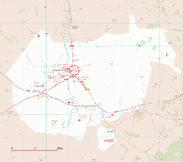

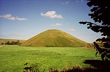 The two monuments of West Kennet Long Barrow and Silbury Hill were constructed in the nearby vicinity of Avebury several centuries before the henge was built.
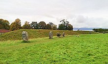 The chronology of Avebury's construction is unclear. It was not designed as a single monument, but is the result of various projects that were undertaken at different times during late prehistory.[19] Aubrey Burl suggests dates of 3000 BC for the central cove, 2900 BC for the inner stone circle, 2600 BC for the outer circle and henge, and around 2400 BC for the avenues.[1]The north-west sector of Avebury
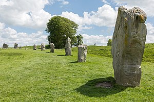
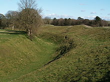 The Avebury monument is a henge, a type of monument consisting of a large circular bank with an internal ditch. The henge is not perfectly circular and measures over 1,000 metres (1,090 yd) in circumference.[23] The only known comparable sites of similar date are only a quarter of the size of Avebury.Part of the outer ditch
 Within the henge is a great outer circle. This is one of Europe's largest stone circles,[28] with a diameter of 331.6 metres (1,088 ft), Britain's largest stone circle.[29] It was either contemporary with, or built around four or five centuries after the earthworks. It is thought that there were originally 98 sarsen standing stones, some weighing in excess of 40 tons. The stones varied in height from 3.6 to 4.2 m, as exemplified at the north and south entrances. Radiocarbon dating of some stone settings indicate a construction date of around 2870–2200 BC.[30]Part of the Outer Circle
 The West Kennet Avenue, an avenue of paired stones, leads from the southeastern entrance of the henge; and traces of a second, the Beckhampton Avenue, lead out from the western entrance.[citation needed]The stone avenue
 The purpose which Neolithic people had for the Avebury monument has remained elusive, although many archaeologists have postulated about its meaning and usage.[34] Archaeologist Aubrey Burl believed that rituals would have been performed at Avebury by Neolithic peoples in order "to appease the malevolent powers of nature" that threatened their existence, such as the winter cold, death and disease.[35]The postulated original layout of Avebury, published in a late 19th-century edition of the Swedish encyclopaedia Nordisk familjebok. Original illustration by John Martin, based on an illustration by John Britton
 Following Stukeley, other writers produced inaccurate theories about how Avebury was built and by whom. The Reverend R. Weaver, in his The Pagan Altar (1840) argued that both Avebury and Stonehenge were built by Phoenicians, an ancient seafaring people whom many Victorian Britons believed had first brought civilisation to the island.[40] James Fergusson disagreed, and in his Rude Stone Monuments in All Countries (1872) put forward the idea that the megalithic monument had been constructed in the Early Mediaeval period to commemorate the final battle of King Arthur, and that Arthur's slain warriors had been buried there.[41] W. S. Blacket introduced a third idea, arguing in his Researches into the Lost Histories of America (1883) that it was Native Americans from the Appalachian Mountains who, in the ancient period crossed the Atlantic Ocean to build the great megalithic monuments of southern Britain.[42]Panoramic view of the southern end of the monument
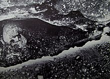 By the Late Mediaeval period, England had been entirely converted to Christianity, and Avebury, being an evidently non-Christian monument, began to be associated with the Devil in the popular imagination of the locals. The largest stone at the southern entrance became known as the Devil's Chair, the three stones that once formed the Beckhampton Cove became known as the Devil's Quoits and the stones inside the North Circle became known as the Devil's Brand-Irons.[51] At some point in the early 14th century, villagers began to demolish the monument by pulling down the large standing stones and burying them in ready-dug pits at the side, presumably because they were seen as having been erected by the Devil and thereby being in opposition to the village's Christian beliefs.[52] Although it is unknown how this situation came about, archaeologist Aubrey Burl suggests that it might have been at the prompting of the local Christian priest, with the likely contenders being either Thomas Mayn (who served in the village from 1298 to 1319), or John de Hoby (who served from 1319 to 1324).[53]The skeletal remains of the man, likely a barber-surgeon, who was killed in an accident whilst trying to topple the stones at Avebury in the early 14th century.
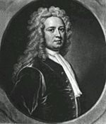 The antiquarians John Aubrey and William Stukeley are responsible for initiating modern study of the Avebury monument.
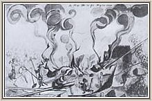 In 1719, the antiquarian William Stukeley visited the site, where he witnessed the destruction being undertaken by the local people. Between then and 1724 he visited the village and its monument six times, sometimes staying for two or three weeks at the Catherine Wheel Inn. In this time, he made meticulous plans of the site, considering it to be a "British Temple", and believing it to having been fashioned by the druids, the Iron Age priests of north-western Europe, in the year 1859 BCE. He developed the idea that the two Inner Circles were a temple to the moon and to the sun respectively, and eventually came to believe that Avebury and its surrounding monuments were a landscaped portrayal of the Trinity, thereby backing up his erroneous ideas that the ancient druids had been followers of a religion very much like Christianity.[63]William Stukeley's drawing of the stones being broken up by fire[62]
 During the 1930s archaeologist Alexander Keiller re-erected many of the stones. Under one, now known as the Barber Stone, the skeleton of a man was discovered. Coins dating from the 1320s were found with the skeleton, and the evidence suggests that the man was fatally injured when the stone fell on him whilst he was digging the hole in which it was to be buried in a mediaeval "rite of destruction". As well as the coins Keiller found a pair of scissors and a lancet, the tools of a barber-surgeon at that time, hence the name given to the stone.[73][74]The Barber Stone
 The Alexander Keiller Museum features the prehistoric artifacts collected by archaeologist and businessman Alexander Keiller, which include many artifacts found at Avebury. The museum is located in the 17th-century stables gallery, and is operated by English Heritage and the National Trust. The nearby 17th-century threshing barn houses a permanent exhibit gallery about Avebury and its history.The Barn Gallery of the Alexander Keiller Museum
 The question of access to the site at certain times of the year has been controversial and The National Trust, who steward and protect the site, have held discussions with a number of groups.[87][88] The National Trust have discouraged commercialism around the site, preventing many souvenir shops from opening up in an attempt to keep the area free from the "customary gaudiness that infiltrates most famous places" in the United Kingdom.[89] Two shops have, however, been opened in the village catering to the tourist market, one of which is the National Trust's own shop. The other, known as The Henge Shop, focuses on selling New Age paraphernalia and books.[90]West Kennet Avenue


No comments:
Post a Comment